Major Fall Storm Bringing Severe Weather, Flash Flooding, And Snow To The Central US
Hello everyone!
While Michael churns towards the Gulf Coast, a non-tropical cyclone over the Central US is bringing a variety of impactful weather to a wide swath of the Plains today. This will continue through tomorrow before the storm responsible for the action moves into Canada. This post will discuss what’s going on this afternoon, and what to expect tomorrow across the center of the country, as well as how to stay on top of it all with the tools we have at weather.us and weathermodels.com.
Here’s a look at the overall pattern this afternoon as seen by GOES-East satellite imagery. The pattern I discussed last week has developed just as forecast, with a deep trough of cold air in the west, and a large ridge of warm air in the east. Between the two, severe thunderstorms have developed, also in accordance with the forecast posted last week. A disturbance has moved into New Mexico today, which has prompted the development of a storm along the frontal boundary draped from Texas through the Plains to the Great Lakes. This frontal boundary is the focal point for severe storms this evening, and will be again tomorrow. Meanwhile to the northwest of the low, snow is falling in an area of heavy banded precipitation. I’ll discuss the impacts of and forecast for both parts of the system in this post.
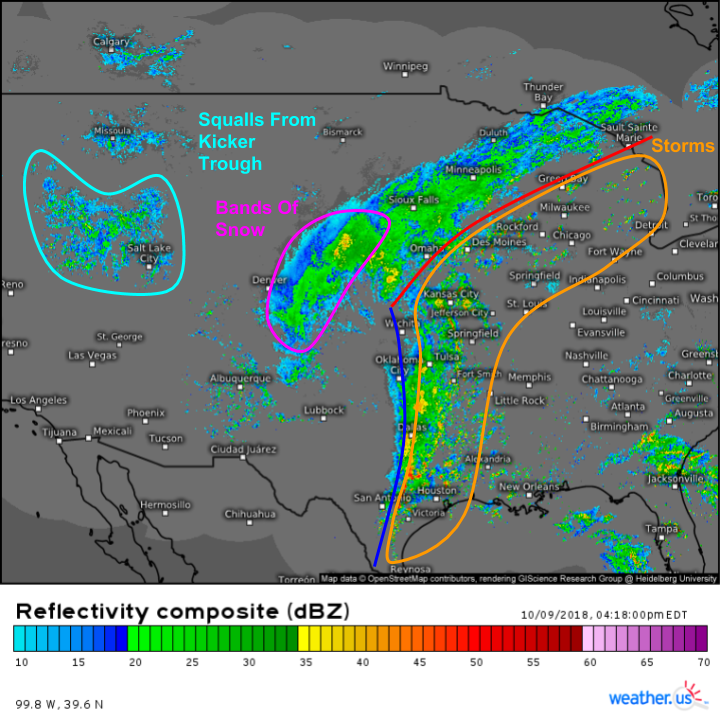
Here’s a look at SD composite radar imagery highlights these features in a more practical way, i.e. in terms of actual precipitation instead of just relative concentrations of water vapor. The corridor of severe storms extends discontinuously from Texas all the way through Wisconsin. The most intense storms are currently producing tornadoes in Iowa. I’ll discuss those in a minute. Meanwhile to the west, we can see bands of heavy rain and snow east of Denver. Squalls are noted on radar near and northwest of Salt Lake City, and are associated with another disturbance digging southeast. That disturbance will eventually “kick” the whole system east tomorrow, hence its designation as the “kicker trough”.
Here’s a closer look at those Iowa storms. The radar images are a little old, the writing of these blogs sadly is not an instantaneous process, but the threat for rotating severe storms continues through this evening, and these images highlight how to use reflectivity and velocity data in tandem to pick out which storms are dangerously rotating, and which are more run of the mill.
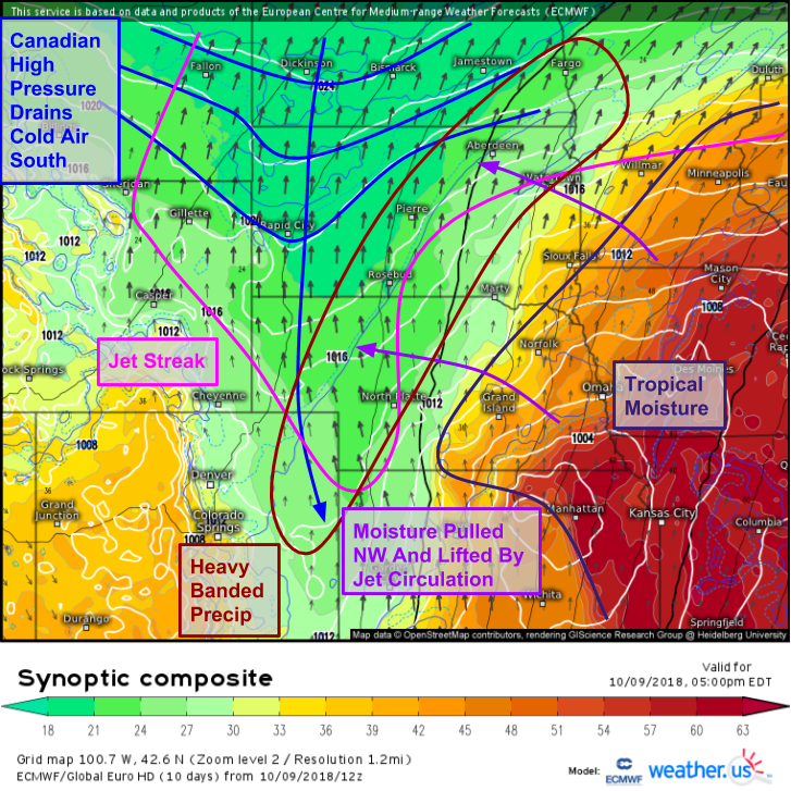
Farther west, we observed that heavy banded precipitation. So what’s up with that? The dynamics are a bit complicated, but the ECMWF’s synoptic composite map (what’s that?) can help us make sense of it all. Starting at the surface, our area of low pressure is analyzed this evening just west of Manhattan Kansas. To the low’s northwest is an area of Canadian high pressure which is feeding cold air south down the eastern side of the Rockies. This cold air is undercutting warm moist air moving northwestward from the east side of the storm towards the right entrance region of a powerful jet streak extending from Nebraska north through the Dakotas. As that moisture is forced to rise into the jet streak above the cold air, heavy rain and snow is produced. That process will continue to unfold tonight and tomorrow as all of these dynamics move northeast.
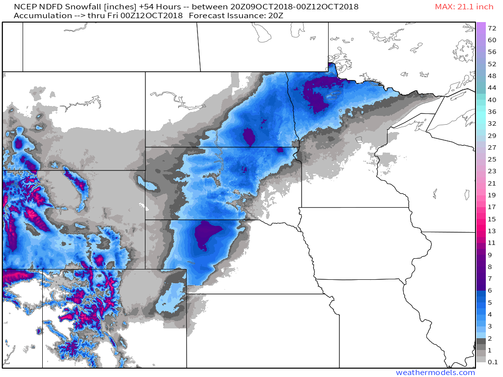
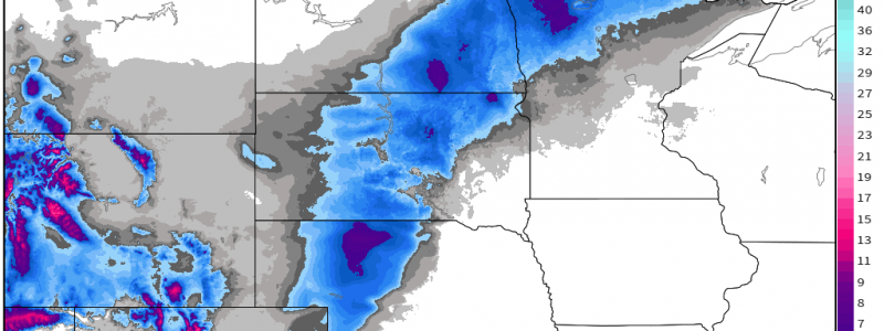
Here’s the NWS forecast for snow totals as the system moves northeast. A general 3-6″ can be expected in most places, with lower amounts the farther away you head from the best dynamics which will pass from Western NE through Central SD into SE ND and NW MN. Also note the high totals in the Rockies as that kicker trough moves through behind the departing main storm. Map via weathermodels.com.
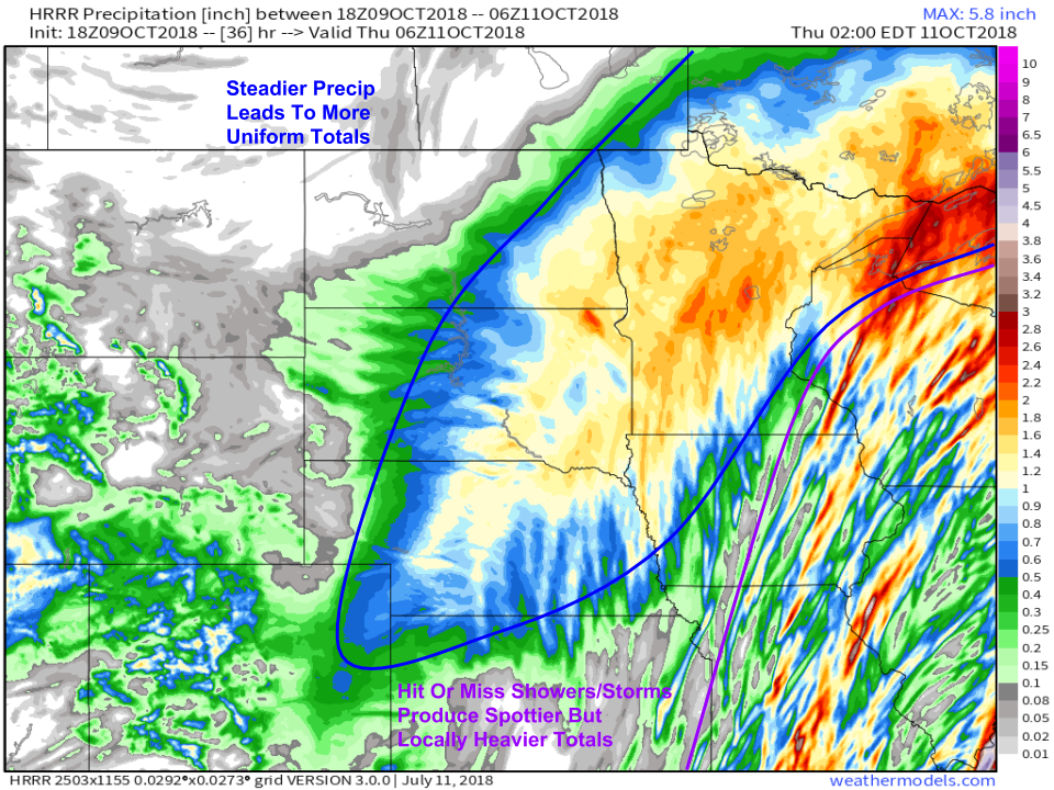
As far as precipitation totals go, the HRRR model has a generally good handle on precipitation distribution over the next 36 hours. The most uniform totals, ranging from a half inch to an inch and a half generally, will be found with the heavy banded precip on the low’s NW side. Rain totals on the SE side, where the severe storms are located, will be locally much higher (up to 4-5″) but also much more localized. Plenty of places will see heavy rain, but plenty of other places barely missed by storm cells, will see very little if any rain. Watch for flash flooding under the heaviest cells. Map via weathermodels.com.
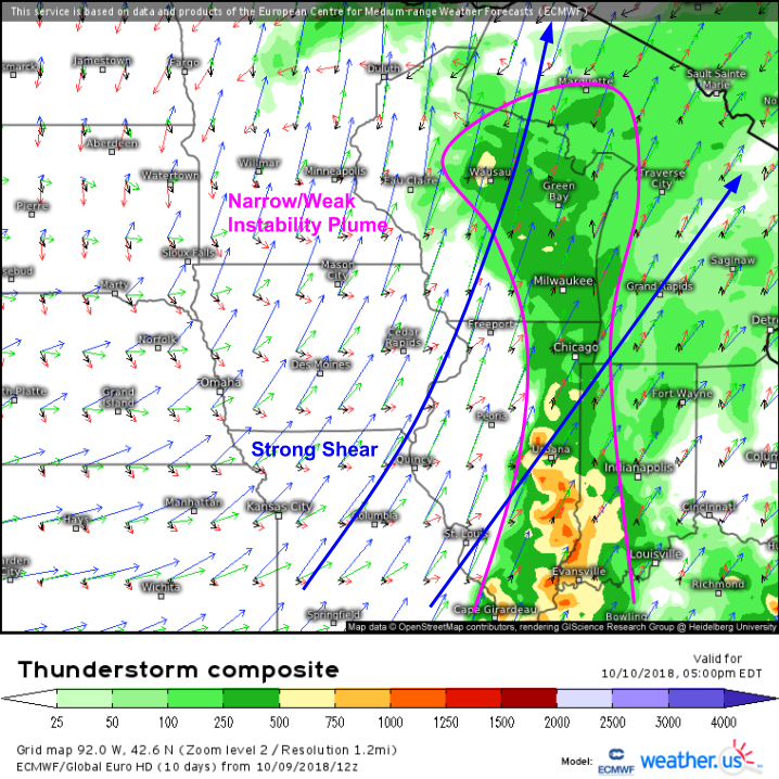
Today’s severe weather threat is focused in Iowa, but tomorrow it will be Wisconsin and Illinois dealing with the storms. The ECMWF’s thunderstorm composite map (what’s that?) shows a corridor of weak instability across these areas, underneath very strong mid-upper level winds (strong shear). With good upward motion along the cold front, expect a line of thunderstorms to develop tomorrow morning, intensifying as it moves east. Damaging winds will be the primary threat from these storms, but tornadoes certainly can’t be ruled out along the leading edge, where “mesovorticies” or small scale rotating structures can easily pop up.
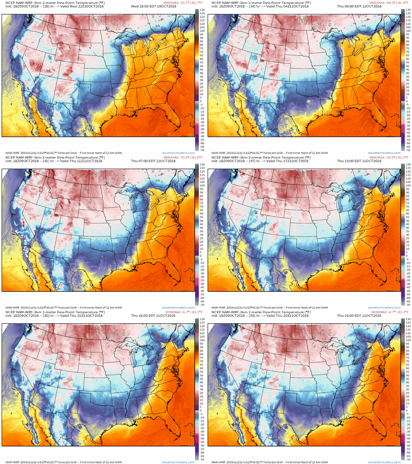
As the storm moves east in the next few days, it will usher in a change of airmass for a wide swath of the country. Cooler and drier air from Canada will pour south behind the cold front, as this animation from weathermodels.com shows. The oppressive humidity (dew points >65) currently in place across the Eastern third of the country will be chased out, leaving much more refreshing air for the weekend.
Of course, we’ll also be following Michael closely in the next few days as it moves through the Southeast. Follow us on Twitter @WeatherdotUS @RyanMaue and @JackSillin for updates on that system.
-Jack

