Eastern Pacific Hurricane Rosa To Bring Heavy Rain To The Desert Southwest Early This Week
Hello everyone!
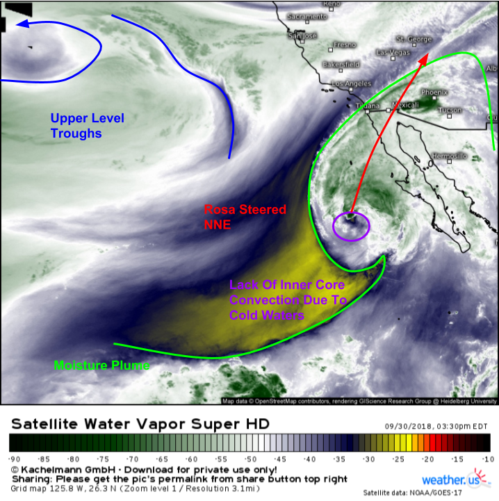
While we do have a tropical system in the Atlantic, Leslie, the tropical entity to watch for US impacts is actually located in the Eastern Pacific this evening. Hurricane Rosa is moving north off the Mexican coast, and is expected to take on a more northeasterly heading later today. This track will take the storm to the northern part of the Baja California peninsula by Monday night. While Rosa will be rapidly weakening due to colder waters, dry air, and increasing wind shear, substantial impacts are still expected in parts of Arizona especially as the storm’s moisture moves northward.
WV satellite imagery this afternoon shows the remnants of Rosa’s inner core located off the Baja coastline. There’s little in the way of convection near the center due to the storm passing over colder waters. However, there’s still plenty of moisture associated with Rosa’s circulation, and that’s getting pulled well ahead of the storm into Arizona. In fact, as of this writing at 4:30 PM EDT (2:30 PM MDT), strong showers and storms are already in progress between Yuma and Phoenix. It’s these showers and storms, that will become even more widespread tomorrow, that will be Rosa’s main impact as they bring the threat for flash flooding to a large swath of the Desert Southwest.
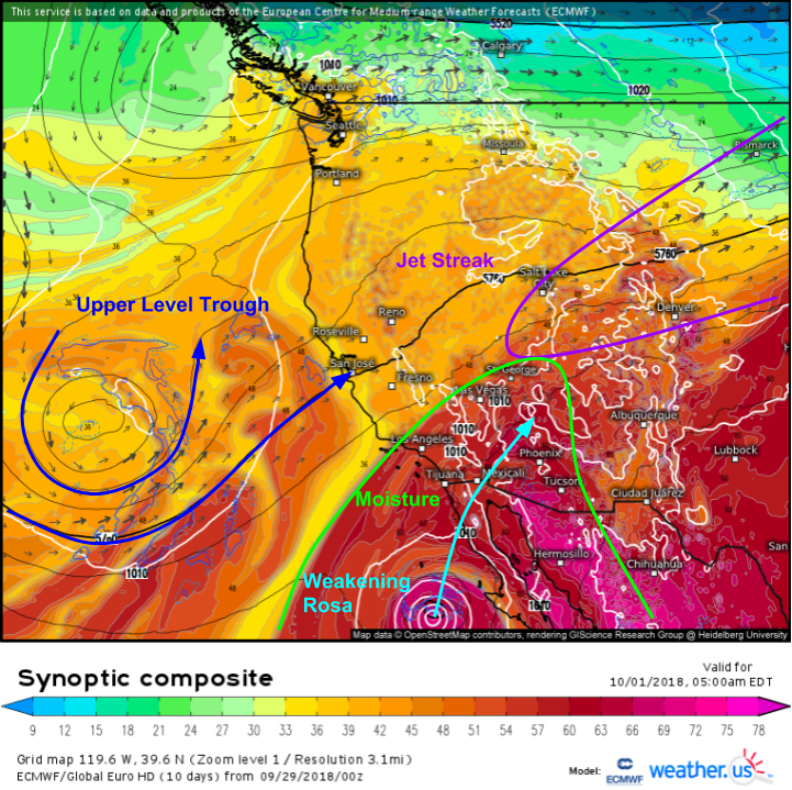
Here’s a look “under the hood” so to speak in terms of the upper level dynamics that will play a part in Rosa’s future via the ECMWF’s synoptic composite map. The two big players will be the upper level trough to the storm’s northwest, and a jet streak to the storm’s northeast. The trough will steer Rosa NNE into Baja California then Arizona. The jet streak will help siphon tropical moisture from the storm’s center northward, and will also help provide the dynamics needed to squeeze that moisture out in the form of rain. Rosa’s moisture field will become more diffuse as it moves over the Rockies, so most of the heavy/problematic rains will be confined to the Desert SW.
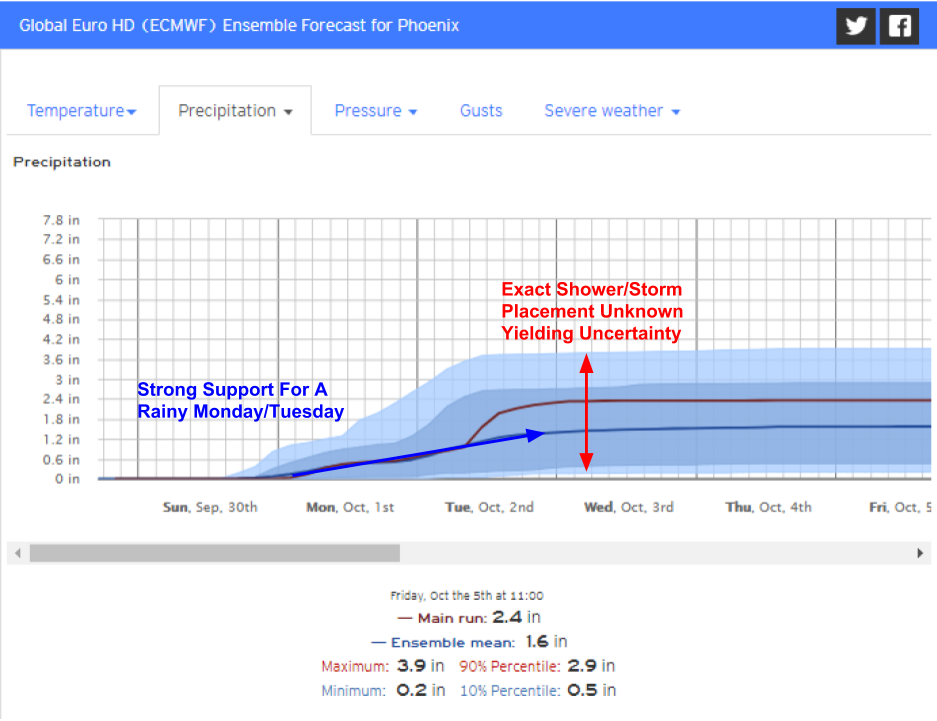
A look at our Forecast Ensemble product for Phoenix highlights the general idea that Monday and Tuesday will both feature rain across Arizona, but that this rain will be in the form of showers/thunderstorms as opposed to a steadier/broader rain shield. This has two impacts for Arizona. First off, there’s still some uncertainty as to exactly how much rain will fall in any given area. This is illustrated by the spread in the forecast graph above. Notice how it’s possible that storms could “train” over Phoenix for several hours, in which case amounts near 4″ are possible, while barely any rain is also possible if those training storms set up just a few miles away. The second impact relates to the intensity of the rain. Instead of the whole state seeing light/moderate rain, some spots will see very heavy rain, while others will see very little. Where it rains, it will pour, and as a result, flash flooding is expected to be a concern. Watch out for rapid rises in rivers, including typically-dormant stream beds becoming active!
Showers and storms will move out of Arizona and into the Central Rockies on Wednesday, but because less in the way of rain is expected, flash flooding won’t be quite as much of a concern. That being said, still do watch out for rapid stream rises in spots that see those pockets of heavier rain.
-Jack


