Tropical Storm Gordon Set Departing Florida This Morning En Route To Louisiana
Hello everyone!
Today’s blog post will discuss the forecast for Tropical Storm Gordon, the cyclone that developed from the tropical wave discussed a couple days ago. The storm is moving through Southern Florida this morning, and will depart the state this afternoon as it moves northwestward through the Gulf of Mexico. The next area expecting impacts from Gordon will be Southeastern Louisiana, where the storm will arrive tomorrow night.
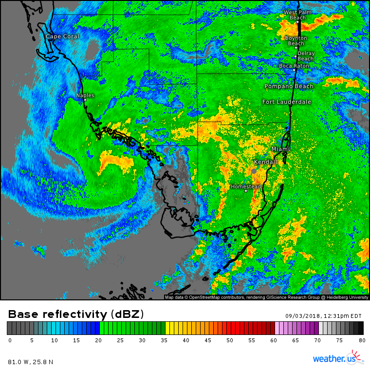
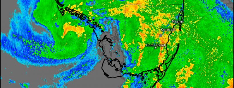
HD radar imagery gives us a good picture of Gordon this afternoon, with the center visible SE of Naples. The semicircle of higher reflectivity values is a sign of Gordon beginning to develop an inner core. If that semicircle can become a fully closed off eyewall, Gordon’s intensity will increase rapidly. Most of Gordon’s thunderstorm activity remains displaced to the east of the center, due to some residual effects from the wind shear that has been affecting the system this weekend. Expect the system to take on a more symmetrical look over the next 24 hours as that shear lessens.
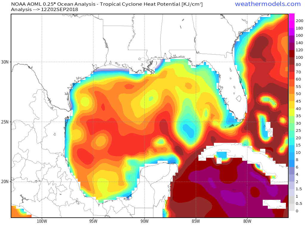
As the storm moves northwest into the Gulf of Mexico, it will continue traversing warm waters with high Tropical Cyclone Heat Potential (TCHP). Basically, TCHP quantifies the amount of fuel available for tropical cyclones, acting as the hurricane equivalent to CAPE for thunderstorms. The more TCHP there is, the more fuel is available for hurricanes. The TCHP along Gordon’s forecast path isn’t quite as extreme as in the Western Caribbean, but is more than enough to support a strong storm if the inner core can organize enough to take advantage.
Map via weathermodels.com.
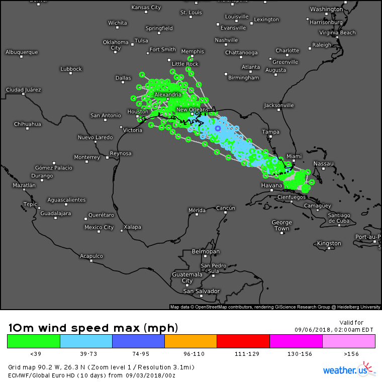
EPS track forecasts are fairly tightly clustered, indicating a fairly high confidence track forecast. Expect Gordon to track NW from its current position in Southern Florida up to the Northern Gulf Coast near New Orleans. The difficult part of this forecast will be intensity. How strong will Gordon be when it arrives in Louisiana? The current official forecasts from the National Hurricane Center calls for a strong tropical storm at landfall. That’s definitely a possibility, but there are a couple red flags this morning that could potentially point to a stronger storm than what’s currently being forecast.
For more info: What are ensembles and how do I use them on weather.us?
An upper level anticyclone (area of high pressure) is developing above Gordon, and will be well established by tonight. This anticyclone in the upper levels will help vent air away from the system in the upper levels, which will “make room” for more air to rise in the storm’s core. It will also shield the storm from wind shear, which has been inhibiting development for the past few days. Both of these factors will contribute to setting the stage favorably for Gordon’s intensification.
Map via weathermodels.com.
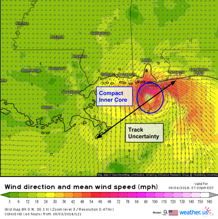
Gordon will approach the Northern Gulf Coast tomorrow evening. Current model forecasts show the storm making landfall with a compact inner core. This means that the storm’s strongest winds will be packed into a small area, but could be quite intense. Storms with small and compact inner cores can organize much faster than those that are larger, so Gordon’s structure makes it a prime candidate for rapid intensification. The storm will only rapidly intensify though if the environmental conditions are right, with warm waters below and an anticyclone above. As we discussed above, both of those elements are in place.
All that to say, while tropical cyclone intensity forecasts are notoriously hard, Gordon is set up perfectly for rapid intensification over the next 30-36 hours before it makes landfall somewhere on the Northern Gulf Coast between Pensacola FL and the mouth of the Mississippi River in Louisiana. How strong could Gordon get? That’s hard to say, but residents of the area I just highlighted should be prepared for a landfalling hurricane tomorrow night. I would say it’s very likely that Gordon reaches hurricane strength before landfall, with additional strengthening beyond that not out of the question.
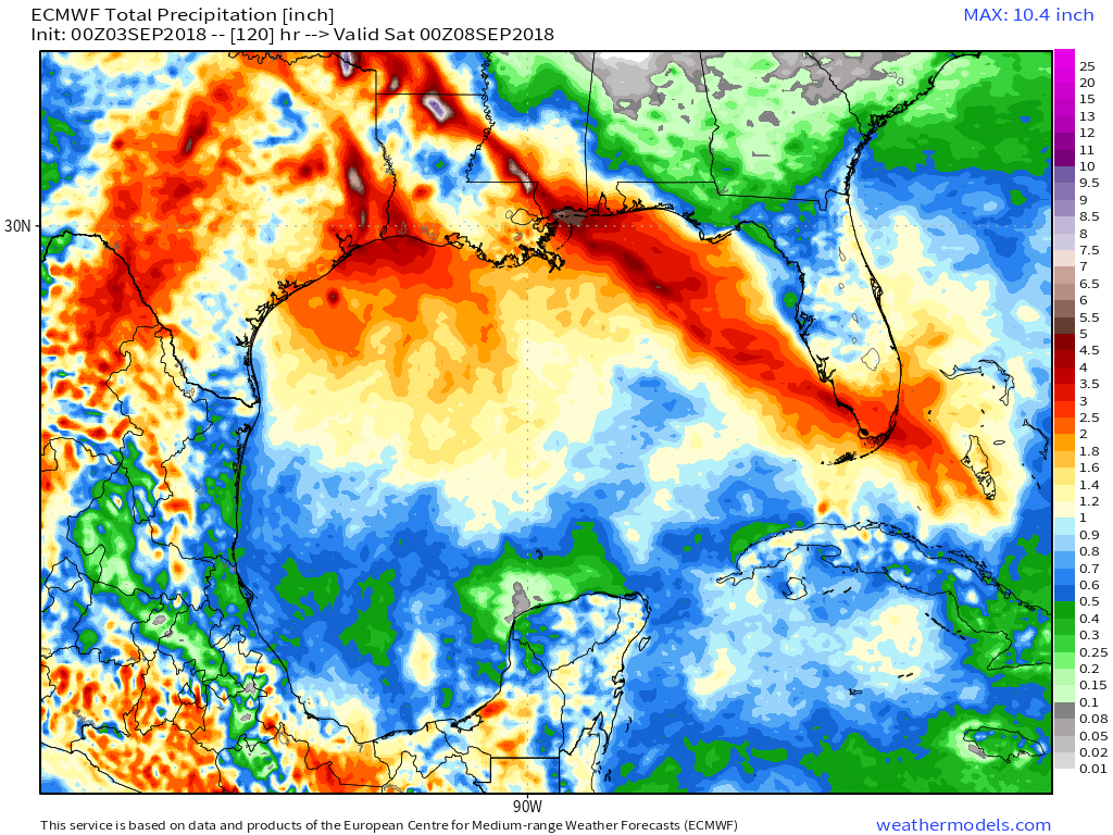
In addition to threats from wind and storm surge in Gordon’s inner core, heavy rain will bring the threat for dangerous flooding to areas slightly farther away from the center. Gordon’s moisture will also interact with a stalled boundary currently bringing flash flooding to parts of Southeastern Texas, resulting in continued heavy rain there. Note that the ECMWF forecast above is an “area averaged” forecast of sorts. It paints a broad brush idea of generally what to expect, but it doesn’t take into account individual thunderstorms. Areas that happen to see individual thunderstorms pass repeatedly overhead (known as “training”) will greatly exceed these forecast amounts, while areas that just happen to miss out on individual storm cells won’t end up getting as much rain as forecast here.
Map via weathermodels.com.
Follow along with the storm at weather.us and weathermodels.com, as well as on twitter where our team will be tweeting more frequent updates @WeatherdotUS, @RyanMaue, and @JackSillin.
-Jack
