Major Hurricane Lane Draws Closer To Hawaii, Severe Impacts Expected Even If Core Remains Offshore
Hello everyone!
Major Hurricane Lane continues to plow west-northwest across the Central Pacific this morning, en route to the waters just west of the Hawaiian Islands. The storm attained Category 5 strength for a time last night, but has since weakened a hair this morning. That being said, it remains an extremely dangerous storm with maximum sustained winds of 155 mph. For reference, it takes 158 mph winds for a storm to be classified as a Cat 5. The storm will turn today, moving NW instead of WNW, before turning NNW tomorrow. The exact track of the storm’s innermost core remains somewhat uncertain, but torrential rain, flash flooding, mudslides, storm surge, and damaging winds are all likely even if the system doesn’t technically make landfall. This post will start off with a quick update on my thinking track wise, and will then move into discussion of impacts.
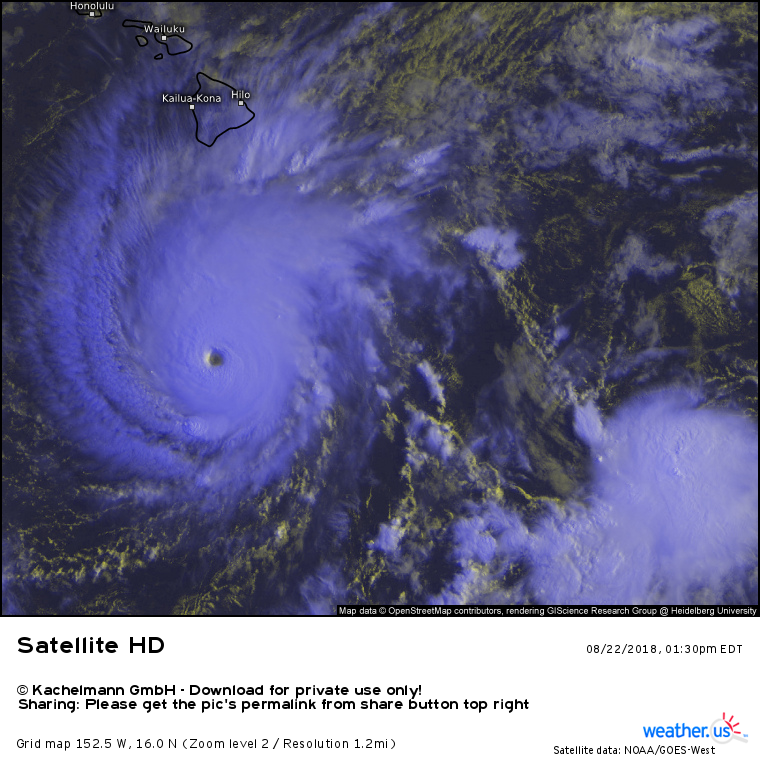
Here’s a look at the storm as seen by satellite imagery. Colder clouds are found higher in the atmosphere, and thus indicate stronger storms. The storm has an impressively symmetric appearance, with intense thunderstorms near the center and healthy outflow spreading out in all directions. While it weakened a hair last night, it remains a powerful system!
In yesterday’s post, I talked about how different mid-upper level features, including a ridge to Lane’s northeast and a trough to the storm’s northwest, were steering the hurricane towards Hawaii. Those dynamics are absolutely still at play, and that discussion still applies today. However, with Lane forecast to begin weakening in the next day or so, it’s worth exploring briefly how the storm’s intensity can impact its track.
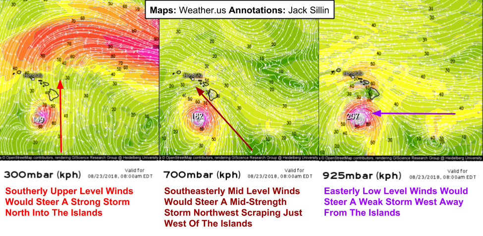
Basically, the stronger a storm is, the more influence upper level winds have on the storm’s steering, while a weaker storm will be steered primarily by low level flow. A look at the large scale winds (not counting the storm’s circulation itself) surrounding Lane tonight show winds blowing from different directions at different altitudes. The farther up you go, the more southerly the winds become, while winds closer to the ground are more easterly. This means that the stronger Lane is, the farther north (east) it will track. The weaker the storm is, the farther west it will track. 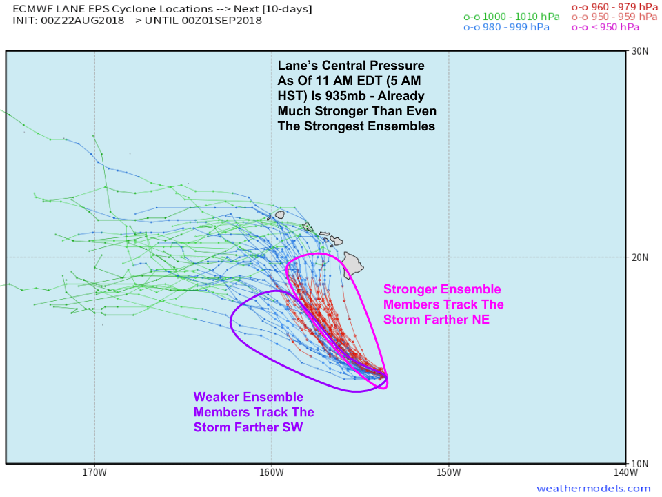
Here’s a way of visualizing the relationship between track and intensity. Note that the ensemble member that forecast a stronger storm also show a track closer to the islands. As a note, Lane’s actual intensity is already much stronger than any model’s forecast, which gives further credibility to the idea of a track closer to the islands.
Map via weathermodels.com.
Another thing to keep an eye on track-wise is the actual position of the storm (from satellite imagery) compared to model forecasts. I’ve plotted a comparison here valid at 5 AM HST (11 AM EDT). Note that both the Euro and GFS models are slightly too far southeast with the storm’s center. As a result, it would make sense that the models may be too far SW with the track later on, as initial errors in weather models increase over time (due to chaos theory!).
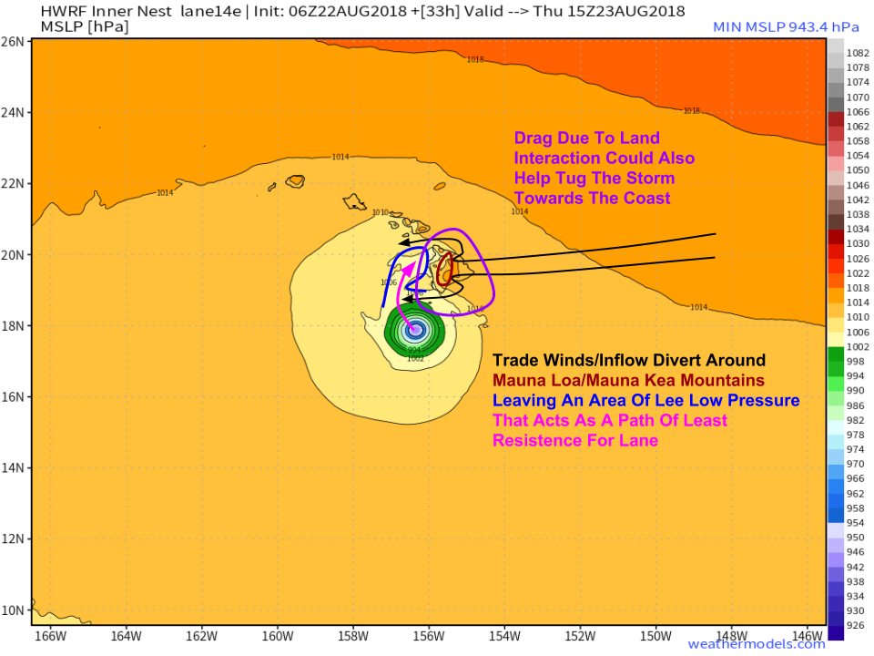
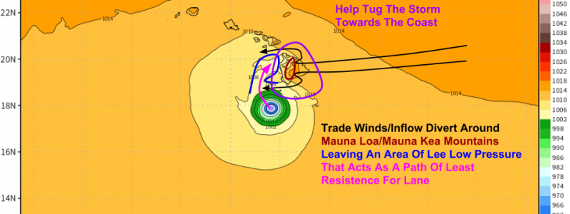
Another factor that will contribute to Lane taking a more easterly track than many models currently forecast is interaction with the terrain of Hawaii’s Big Island. This idea was originally brought to my attention on twitter, with credit going to Timothy Wright for spotting it. Basically, as Lane’s circulation interacts with Hawaii’s Big Island, drag from the island’s mountains will turn the storm to the right. Furthermore, the lower pressures found in the lee of the island will help create a ‘path of least resistance’ of sorts to tug the storm a little more to the north as opposed to northwest. It will be a matter of a few miles as to whether or not the eye actually moves onshore, but regardless, severe impacts are expected even with a brush of the inner core.
All the factors discussed above, combined with the factors mentioned in last night’s post continue to point towards a track closer to the Hawaiian Islands, in my opinion. That doesn’t mean that a landfall is guaranteed, or even expected, just that I continue to believe based on the information available that the ECMWF model’s idea of a track far enough west to spare the islands of impactful winds is unlikely. However, regardless of exact track, severe impacts are expected especially with regards to heavy rain.
Map via weathermodels.com.
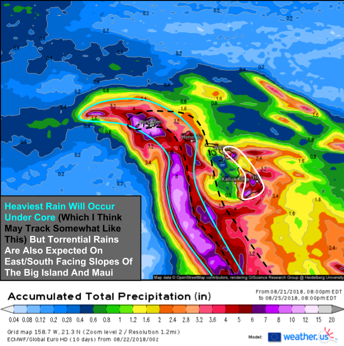
Here’s a quick look at potential rainfall totals over the next few days as Lane moves just west of most of the Hawaiian Islands. Note that while the heaviest rains are located near the storm’s center (which I believe I’ve shown will move farther east than what the European model shows), very high totals (which will end up being much higher than what’s shown here) are expected along the southern/eastern slopes of Maui and the Big Island due to hyper-localized orographic uplift (air rising due to running into mountains). These areas should remain extremely vigilant for flash flooding and mudslides starting today, as the first rain bands are about to move onshore in the next couple hours.
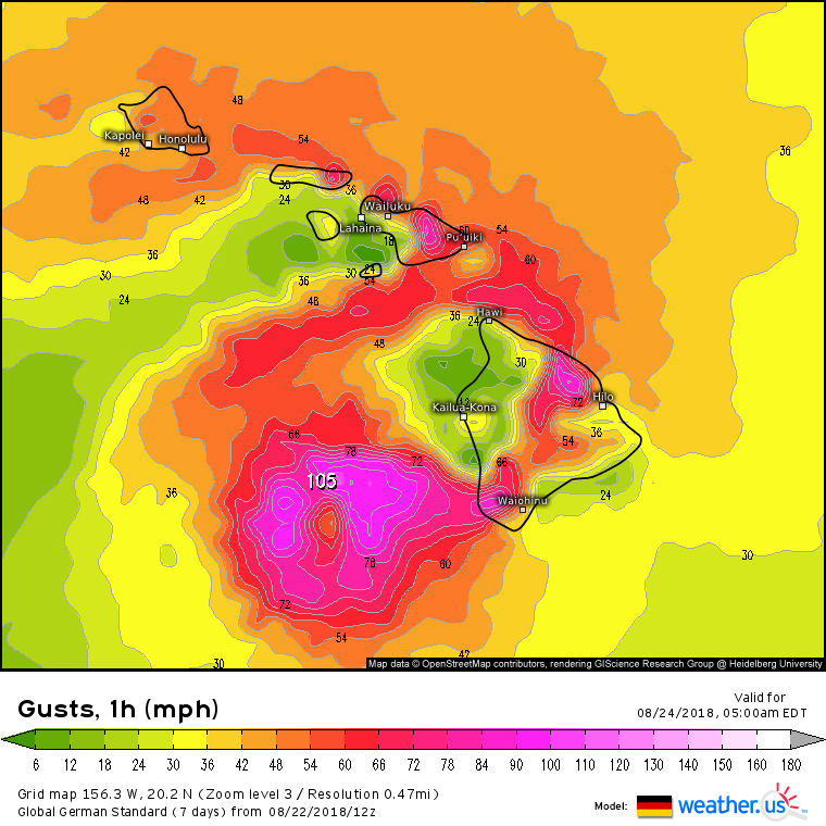
Winds will be much more dependent on the core’s exact track, as this forecast from the German model shows. Note the area of very intense winds immediately surrounding the calm eye, and the much lower winds farther away from the core. A wobble of just a few miles east, which given the observational evidence provided above is certainly possible, would bring those hurricane force winds just offshore into SW parts of the Big Island, as well as SW parts of Maui and its surrounding islands. Much of the west coast of the Big Island will remain insulated from the highest winds by the terrain to its east, but if the core approaches close enough, damaging winds are possible there too. While unlikely, it’s also possible that the storm wobbles west a bit, which would in turn result in lower winds. Also note the gusty winds (>40 mph) all the way up into Oahu, even while the core is well south. The entire island chain should be ready for gusty winds above 40 mph, especially east/northeast facing beaches and slopes.
Track the storm’s incoming rain bands with HD radar, keep an eye on its overall structure with satellite imagery, and get town-specific forecast info right from our homepage by simply typing your town’s name into the search box.
I’ll have more info on Lane this evening on twitter, both at @WeatherdotUS and @JackSillin.
-Jack
