Hurricane Lane Likely To Bring Significant Direct Impacts To The Hawaiian Islands
Hello everyone!
While typical summertime weather continues across the Continental US, an unusual situation is set to unfold in the Central Pacific as Major Hurricane Lane approaches the Hawaiian Islands. The storm was located 575 miles SSE of Honolulu as of the 11:00 AM HST (4 PM EDT) advisory from the Central Pacific Hurricane Center, with sustained winds of 155 mph. The storm is heading WNW at the moment, but will turn to the north tomorrow as steering patterns change. In this post, I’ll break down some of the factors behind the forecast for Lane, including what I expect and why. I’ll also link to some of the many resources we have to follow the storm at weather.us and weathermodels.com.
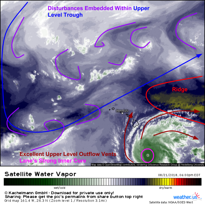
If you’ve followed my postings for a little while, you’ll know I like to start nearly all of my posts with a look at Water Vapor satellite imagery. There’s a reason for that: it’s a great way to analyze many features at once, and actual pictures of the Earth’s atmosphere are much more valuable than model data, which is just a simulation of what might be going on, as opposed to what’s actually going on.
The general pattern surrounding Lane is fairly self explanatory. A trough sits to the system’s northwest, while a ridge occupies the space northeast of the storm. Air flows clockwise around ridges and counterclockwise around troughs, which means the storm is set to enter an area of southerly steering flow after it moves west around the base of the ridge. It doesn’t take an advanced understanding of the atmosphere to see what will happen when the storm moves a little west then turns north.
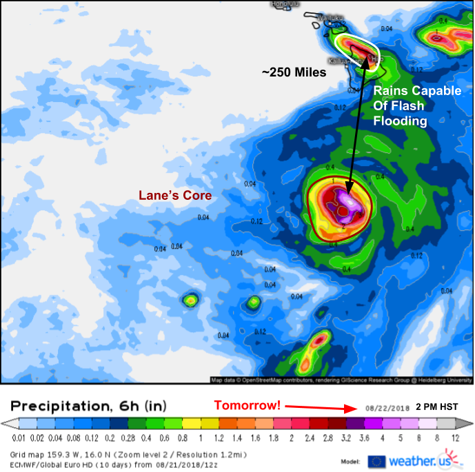
While the storm’s inner core may or may not move onshore on one of the Hawaiian islands, a hurricane is not a point feature. Strong winds and heavy rains can and do extend hundreds of miles from the storm’s eye. To illustrate this, check out the ECMWF model’s forecast for tomorrow afternoon (HST). Lane’s core is around 250 miles from the Big Island, but torrential rains capable of flash flooding and mudslides are already well underway. If Lane’s core does make landfall, impacts will start well before the center arrives, and even if Lane’s core remains offshore, it will still produce very impactful weather.
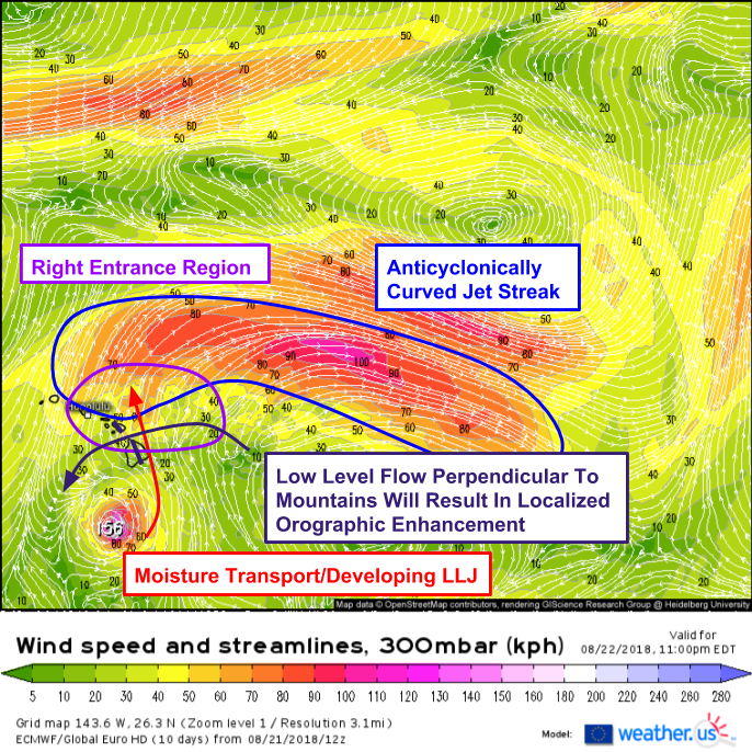
Why is this setup so ripe for rain to spread far away from the center? A look at the upper levels explains. A large anticyclonically curved jet streak is noted to the storm’s northeast. The entrance region of this jet is located over the Hawaiian islands. In the right entrance region of an anticyclonically curved jet (in the Northern Hemisphere at least), air accelerating into the jet core leaves an area of low pressure aloft, which air from lower in the atmosphere, and to the south/southeast of the RER moves to fill. This results in both the development of a low level jet, and rising motion. The low level jet will whisk moisture northward from Lane’s core, while the large scale rising motion of the jet combines with small scale rising motion due to orographic lifting from Hawaii’s tall volcanic peaks. Both synoptic (large) and mesoscale (smaller) scale features are lining up for torrential rains, especially on the Big Island and Maui. These rains will begin tomorrow, so if your area is prone to flooding, prepare now!
Because the flooding setup involves large scale, predictable features (i.e. the large jet streak) and doesn’t depend on the exact core track, it is a high confidence forecast. Be ready, it’s coming! Remember that in areas with or near steep terrain, mudslides are a threat in addition to fast-moving water.
So what about the core of the storm, that’s where the worst weather is, right? Absolutely, the hurricane’s strongest winds are contained within the ring of thunderstorms immediately surrounding the eye. If these storms, known as the eyewall, rotate onshore, extensive wind damage will occur even as the hurricane loses some of the strength it has this evening before it makes landfall. So where will the core track?
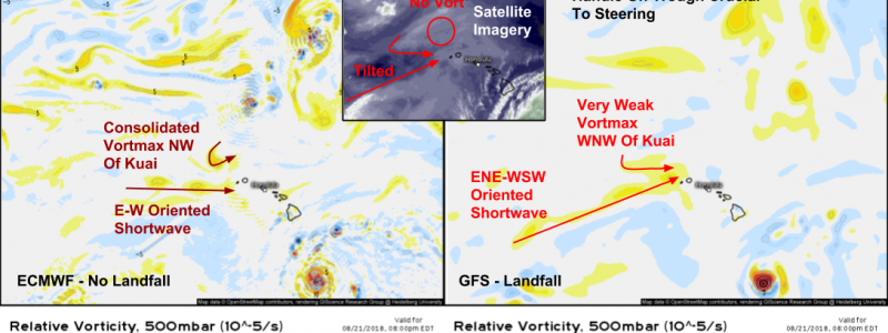
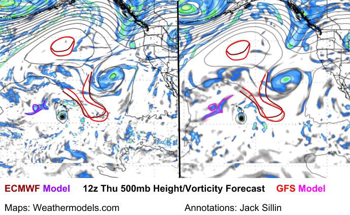
The maps above highlight two different possibilities. The ECMWF, on the left, forecasts the core remaining just offshore. The GFS, on the right, forecasts a landfall. So why the difference? It’s easy to spot in the mid/upper level maps such as the one shown here for 500mb. The GFS has a weaker ridge to the northeast of the storm, and a stronger/more consolidated disturbance to the northwest. Remember the direction winds spin around ridges and troughs- the trough to the storm’s NW is exerting eastward steering pressures on the storm, with the ridge to the storm’s NE pushing in the opposite direction. If the trough is stronger than the ridge, the storm will make landfall in Hawaii, with the reverse also being true for a weaker trough/stronger ridge. So which is more likely?
Maps via weathermodels.com.
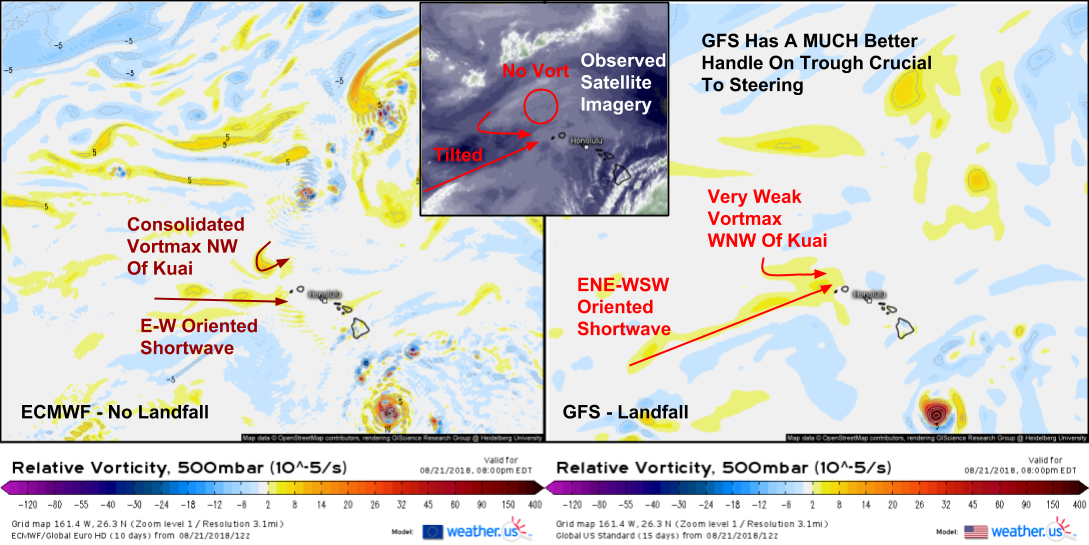
A very close look at WV imagery compared to model forecasts shows that the GFS has a MUCH better handle on the trough elements crucial to Lane’s steering. The graphic above illustrates that. While there is still time for the forecast to change, and the GFS model is far from perfect, the fact that real time observations, in the form of satellite imagery, support its solution means that my forecast will align more closely with the GFS’s thoughts, compared to those of the Euro.
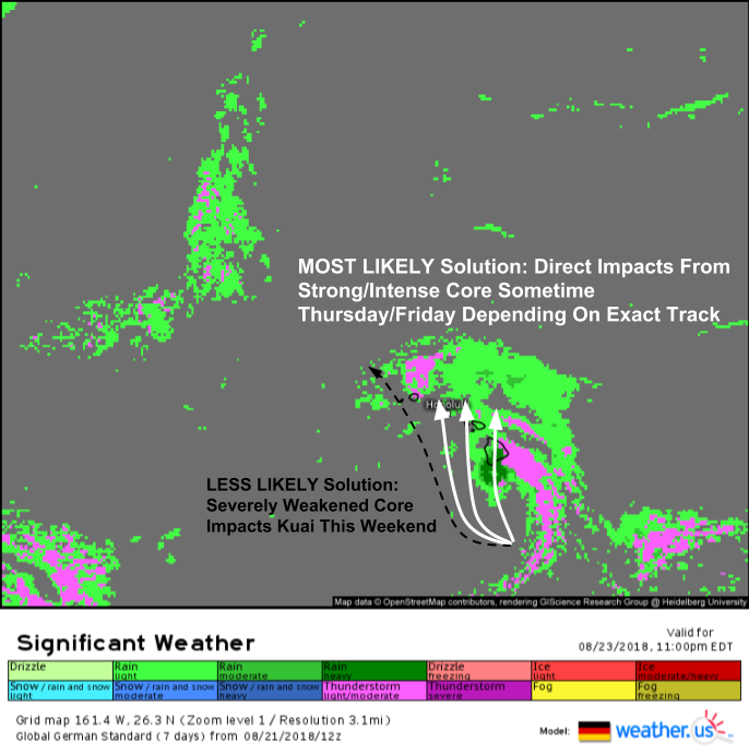
Here’s a look at one possible landfall solution, provided by the German model which is expecting a landfall on the Big Island Thursday. It’s also possible that the storm stays a little farther west and moves ashore on Maui or Oahu on Friday. The less likely, though still possible, solution is for a track much farther to the west with direct impacts from a much weaker core this weekend.
I’ll have more information on specific impacts tomorrow.
Track the storm with satellite imagery, and watch the outer bands begin to move ashore on radar by clicking the respective links. Need town-specific information to hone your preparation plan? Type your town into the search box on our homepage to get town-specific forecasts. Keep in mind though which model that data comes from (hint: we let you pick, as opposed to other weather sites which don’t even tell you!). For the most accurate data, pick the GFS (American) model instead of the ECMWF (Euro) model, due to the errors discussed above.
-Jack


Wednesday morning, 08-22-18, Mauna Loa is a pretty big MTN for a hurricane to go up against, yes very tricky track that could do some real damage more than blow over a tree or three. But we never have seen a hurricane make direct landfall and keep going against this behemoth monster mountain at 13,600′ ft, it would make an interesting story if it could. Lane vs the mega mountain. Almost like the children’s fairy tail … I’ll huff and puff … Lane can come but can’t blow the mountain down.
The real serious danger here is a track north just off the west side of the Big Island, with a storm surge as it goes and a big storm surge on Maui and Oahu. Oahu- Honolulu/Waikiki is very near sea level on the South side of the Island where the storm surge would hit.
Too soon to say for sure but Lane has all the makings to be a very dangerous and destructive storm for the Islands of Hawaii. Stay safe everybody, J Par