Chris Accelerates NE, Heat Dome Continues To Limit Severe Storm Activity, SW Monsoon Now Well Underway
Hello everyone!
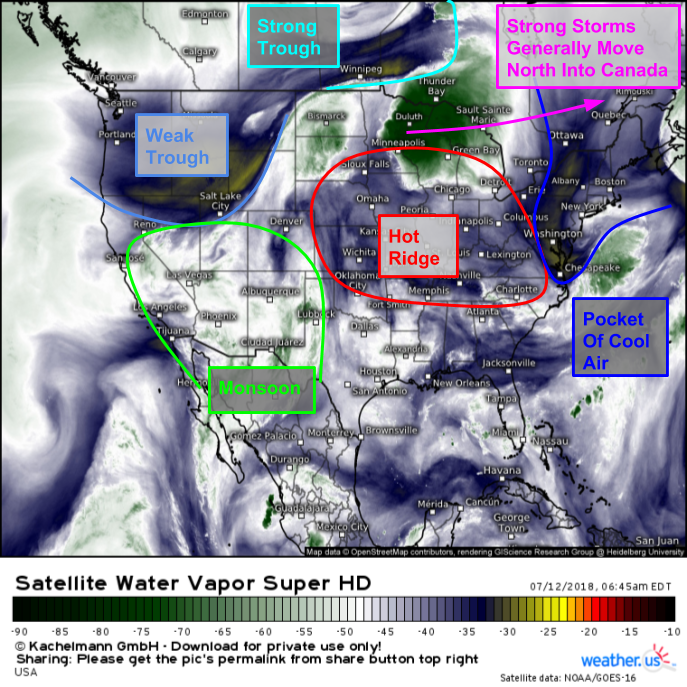
With a generally quiet pattern in place across the US, this post will be a collection of shorter notes on a few lower impact systems. Hurricane Chris has accelerated NE off the East Coast, and will move ashore in Newfoundland today. Its only remaining US impacts will be in the form of rip currents along the Northeast Coast. Farther west, the ridge of high pressure responsible for the early month heatwave has moved back towards the Midwest, with thunderstorm activity confined to its northern fringe. Even farther west, the annual SW Monsoon is well underway across the Desert Southwest, with showers and thunderstorms popping up each afternoon across Arizona and New Mexico.
GOES-East WV satellite imagery highlights each and every one of those features this morning, combined with a few more. Hurricane Chris is the small semicircle at the far right of the image, over Eastern Nova Scotia. The storm is being escorted offshore by an upper level trough bringing cool and dry weather to the Northeast. Under the ridge of high pressure centered in Missouri, hot weather will continue today with high temps over 100 degrees expected in some areas. The deep green shadings over Minnesota point to thunderstorm activity, which will continue along the ridge’s northern periphery.
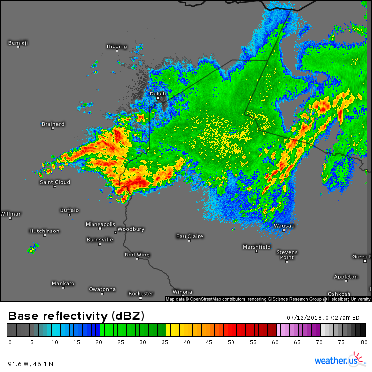
This HD radar image of Eastern MN/Northern WI gives us a more detailed look at the thunderstorms seen on the GOES-East imagery above. Notice the storms oriented along WSW-ENE axes. HD radar loops show storms moving generally eastward this morning. The very subtle difference between the axes of storm activity and the storms’ motion is resulting in “training” where thunderstorms pass over the same areas repeatedly, like train cars passing over a particular stretch of track. As a result, flash flooding has been occurring with flash flood warnings posted for much of this cluster.
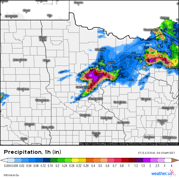
This map shows radar derived precipitation between 4 and 5 AM CDT. Over 1″ of rain fell across a wide swath of area SW of Duluth, with some towns receiving 2″! These very heavy rain rates, combined with the training discussed above, will result in a continued flash flood threat through the rest of this morning until this cluster of storms moves east and weakens.
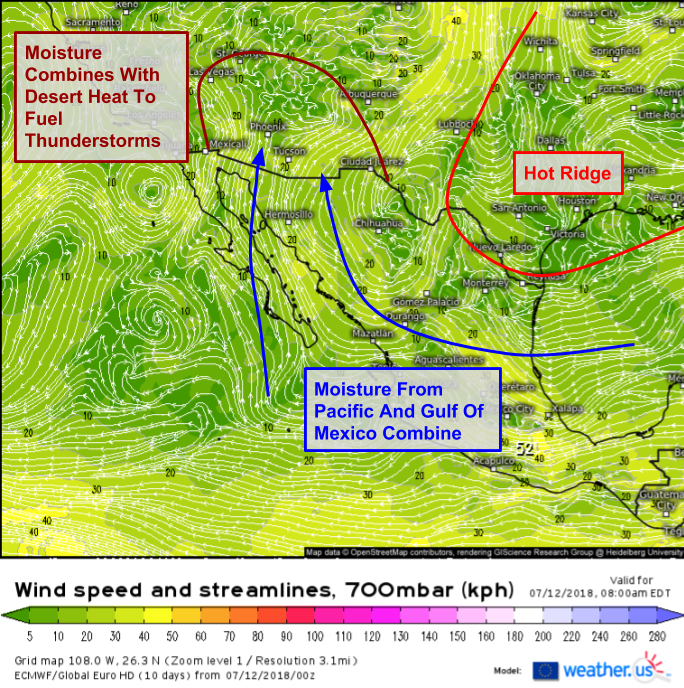
In the Southwestern US, the story for the next few days (and weeks for that matter) will be the Monsoon, which is now in full swing. This ECMWF mid level (700mb) wind forecast explains how the typically arid states of Arizona and New Mexico are now set up for thunderstorms producing torrential downpours. When the ridge of high pressure that brings heat to the Central/Eastern US sets up each year, clockwise flow around it sets up easterly flow from the Gulf of Mexico and southerly flow from the Tropical Eastern Pacific. The combined stream of moisture then moves into Arizona and New Mexico, setting up the monsoon and its thunderstorm activity.
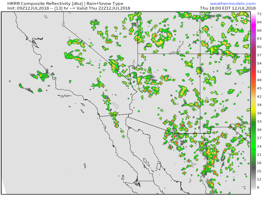
What do the results of the Monsoon look like? This simulated radar image from weathermodels.com provides the answer. Note the widespread scattered shower/thunderstorm activity across not just AZ and NM, but also parts of CA, NV, UT, and CO. The Monsoon’s impacts can be far-reaching! Storms generally will remain below severe limits, though sometimes the stronger cells can produce strong winds capable of wind damage. Even sub-severe storms can produce gusty winds that occasionally kick up the desert sands into large dust storms, known as haboobs (yes, that is a real scientific term). Even though they may or may not be accompanied by severe, damage-producing winds, haboobs are hazardous in several ways. They dramatically reduce visibility and the large volumes of dust in the air can be harmful to those caught outside.
For more information on your local forecast: https://weather.us/
For more information on the local forecast for ME/NH: https://forecasterjack.com/2018/07/12/another-summer-stunner/
-Jack
