Tropical Moisture And Upper Level Trough Combining To Cause Flash Flooding In Texas And Iowa Today
Hello everyone!
The tropical disturbance located off the Southern Texas coastline, dubbed 91L by the National Hurricane Center (NHC) will remain the focal point for active weather across the US again today. The system itself will continue to pose a flash flood risk to Southern/Coastal Texas, while moisture siphoned north from the system will help drive heavy rains over parts of Iowa and adjacent areas in the Upper Midwest, which will also pose a substantial flash flood threat.
Here’s a look at GOES-East water vapor satellite imagery which highlights the atmospheric features responsible for today’s flood threats. 91L is clearly visible near Brownsville Texas with its mass of tropical convection (thunderstorm activity). An upper level trough is clearly evident over the Western Plains, with a center of circulation of sorts located NE of Denver. The building moisture link is also visible, especially in looped imagery (accessible via link) asthe northward moving surge of darker colors in OK/AR/MO. As this moisture moves into Iowa later this afternoon, look for currently light rain to pick up in intensity.
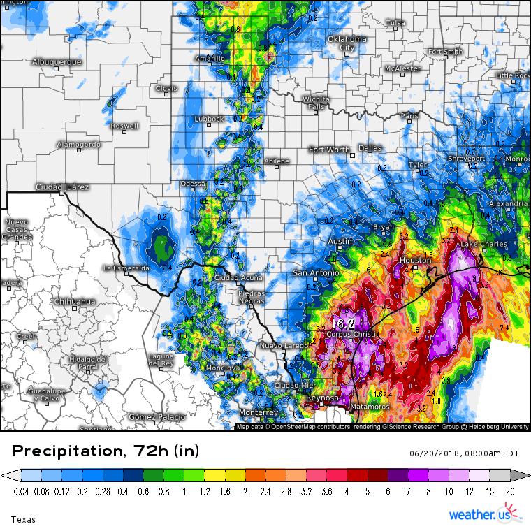
Three day radar estimated precipitation totals across Southern/Coastal Texas are impressive, as we predicted last week. Amounts near Corpus Christi and east of Houston have likely neared or exceeded the one foot mark, and more rain is falling today. After so much rain has fallen, soils become saturated, and their ability to absorb water greatly decreases. As a result, what on a normal day might be a garden variety shower will today pose a serious flash flood threat. Be aware of flash flooding if you’re in these areas today, and remember never to drive through flooded roadways.
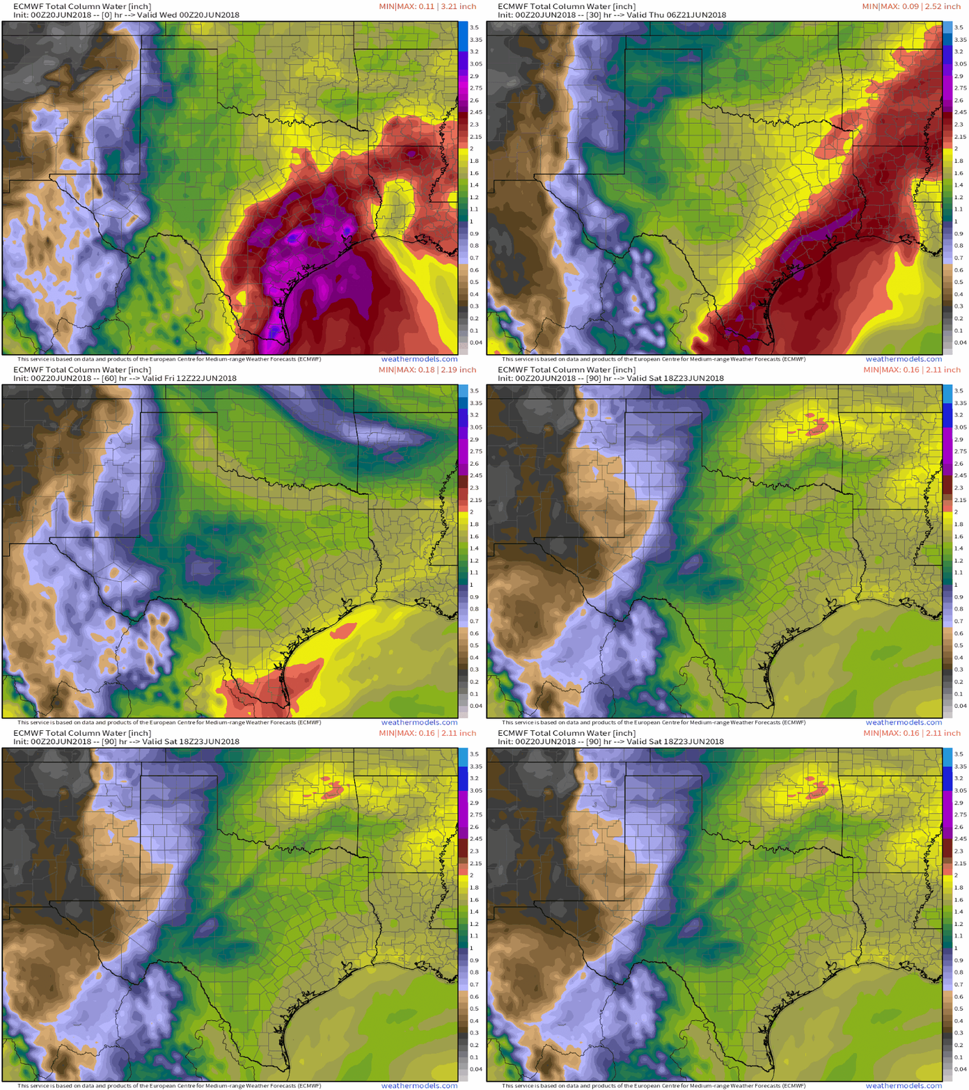
An animation of the ECMWF’s precipitable water (moisture) forecast for the next several days shows 91L’s plume of deep tropical moisture (red shadings indicating PWAT values >2″) sticking around through tomorrow before drier air slowly moves in on Friday. As a result, look for more rain tomorrow before a drying trend as we approach the weekend. GIF via weathermodels.com.
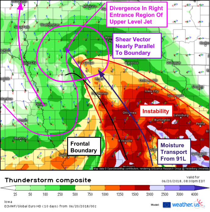
Farther north in Iowa, dynamics out ahead of the upper level trough discussed above will set the stage for training thunderstorm activity along a frontal boundary tonight. An axis of instability will be present from the Southeastern corner of the state towards the center, while the western part of the state will sit under the entrance region of an upper level jet. Between the two will be a frontal boundary that will help provide the trigger for storm initiation later this afternoon. Storms that develop along the boundary will move to the northwest due to southeasterly flow ahead of the trough. This will leave room for new storms to form along the boundary, following in the footsteps of the previous storms. You can see how this setup would be conducive for “training” thunderstorms that pass over the same areas repeatedly, like train cars over a stretch of track. This map is the ECMWF’s thunderstorm composite map, a great tool for diagnosing thunderstorm potential.
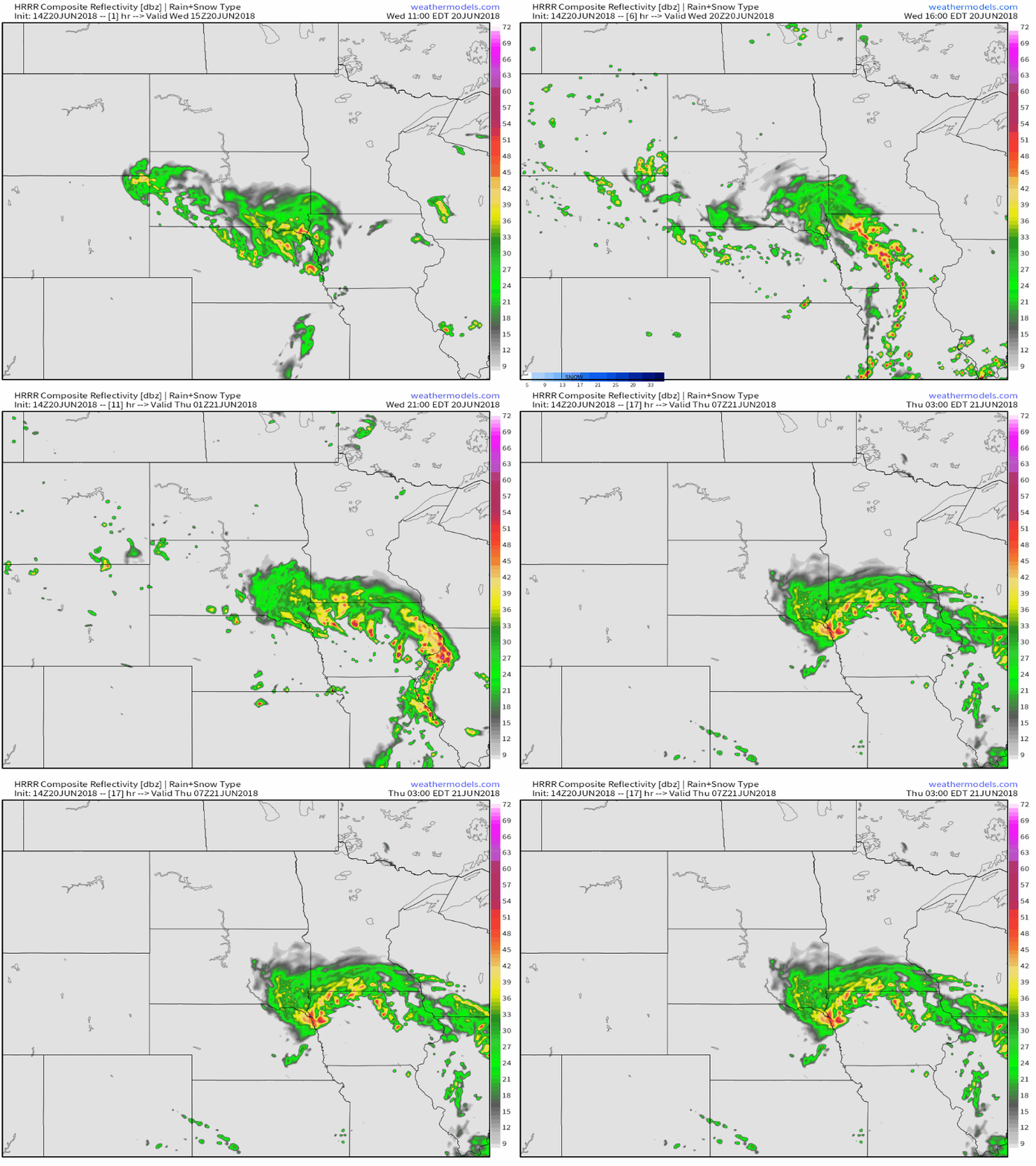
If that process is hard to visualize, this animation from the HRRR model via weathermodels.com might help. In the simulated radar loop, see how storms in NW Iowa continually sit and train over the same locations for hours at a time? That’s the process I’m talking about. While storms will clear up by tomorrow morning, and no astronomically high rainfall totals are expected, several inches of rain falling in just a couple hours under these storms will be enough to cause flash flooding issues. Due to generally weak wind shear, severe thunderstorm activity isn’t expected to be widespread, though storms farther southeast in Iowa could produce some gusty winds.
Elsewhere across the country today, some marginally severe storms are expected in parts of the Mid Atlantic, as well as farther south in the Mississippi river valley, however widespread severe thunderstorm activity is not expected. Quiet severe weather is also expected tomorrow, while 91L’s rains continue across South Texas.
My next update will be on Friday afternoon. Meanwhile, you have all the tools you need to stay on top of all the storm activity forecast over the next few days, from garden variety pop up storms in the Southeast to marginally severe storms in the Mid Atlantic, to the flash flood producing storms in Iowa and Texas. GOES-East satellite imagery, HD radar imagery, and our lightning analysis tool will all be valuable in staying ahead of the storms, no matter how strong. You can click any of our maps to zoom in for a closer look.
If you’re just looking for the forecast for your town to see if you might have to worry about storms over the next couple days, it’s easy to find basic forecast info at weather.us simply by typing your town’s name into the search box on our homepage. This will bring you to our weather overview page, from which you can get forecast info from the next few hours all the way out to the next two weeks.
-Jack


