Early Evening Thunderstorm Update 6-9-18
Hello everyone!
I discussed today’s severe thunderstorm setup a little bit on twitter this morning (you can find tweets from myself and the rest of the weather.us team at @WeatherdotUS, and you can find my tweets @JackSillin) but now that storms are actually developing, I wanted to take a look at some of the features you can spot with our storm tracking products. Click any of the links below to see live data over at weather.us and explore the products yourself.
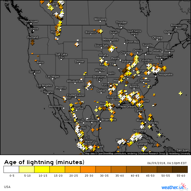
A look at the nationwide lightning analysis overview this evening shows no shortage of ongoing thunderstorm activity across the country. I’ll briefly go over some of the areas particularly active in not just lightning activity, but also severe weather activity in this post. To get strike-specific info, click the national map to zoom into state level, then click again to zoom into county level. Once you’re at county level, you can click individual strike icons to get street level strike mapping, and information about the strike’s power. For a full tutorial of our lightning analysis product, click here.
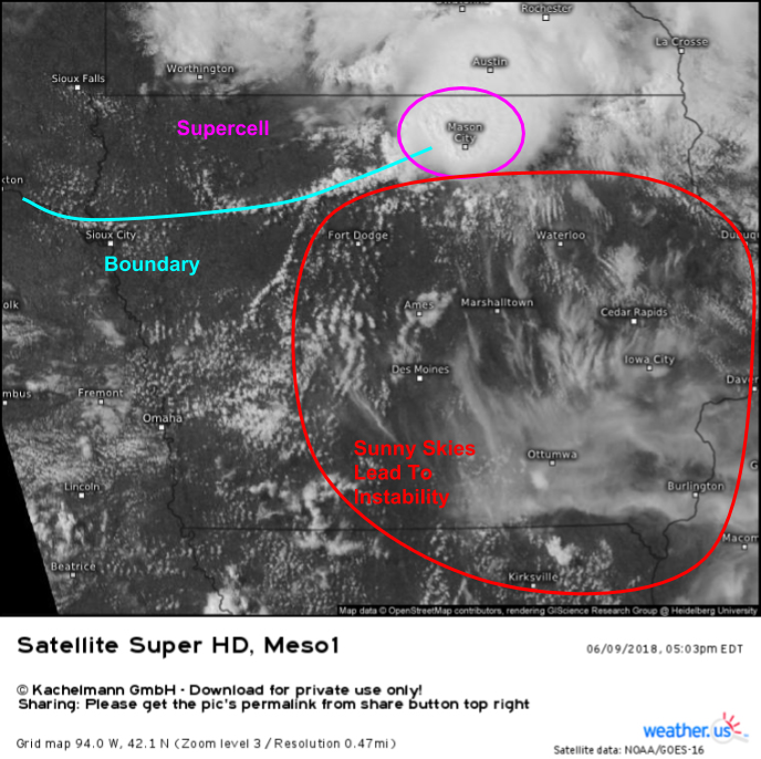
This evening’s most intense storms are, and will continue to be, located across parts of the Northern Mississippi valley from Southern MN to Northern IA. A supercell has erupted along a boundary in this area, and sunny skies to that storm’s southeast will continue to create a favorably unstable environment for storms through the rest of the evening into the early part of tonight. As time goes on, look for storms to coalesce into linear structures, with a transition in threat away from tornadoes and towards damaging straight line winds. However, until this process occurs, tornadoes and very large hail will be serious threats in addition to strong winds, heavy rain, and lightning.
Track the storms with GOES-East satellite imagery, HD radar imagery, and lightning analysis. Click any one of the maps at the link to zoom into county level for a closer look. Or if you want more zoom flexibility, try custom zoom mode, available via the menus to the left of the image.
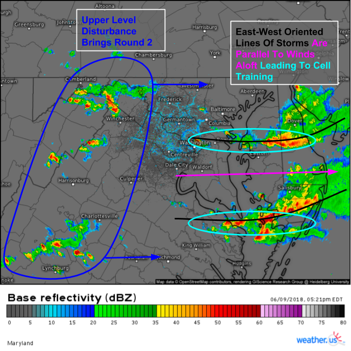
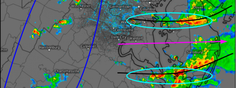
In the Mid Atlantic, storms have formed in the vicinity of a stalled frontal boundary. Two weak upper level disturbances are moving east above this boundary, and storms are organized into two waves as a result. The first wave is located over the Delmarva peninsula, and is slowly weakening. The second round is strengthening as it moves East off the Appalachians and towards the Virginian lowlands. Small scale processes have organized the first round storms into two lines, generally oriented west to east. Winds aloft are blowing out of the west, parallel to these lines. Due to the orientation of these boundaries relative to winds aloft, storm cells are moving along these boundaries, “training” repeatedly over the same locations. This will result in a flash flood threat as the same areas receive repeated rounds of heavy rain. Lightning will also be a threat with these storms, despite their general lack of severe wind/hail.
Track the storms with GOES-East satellite imagery, HD radar imagery, and lightning analysis. Click any one of the maps at the link to zoom into county level for a closer look. Or if you want more zoom flexibility, try custom zoom mode, available via the menus to the left of the image.
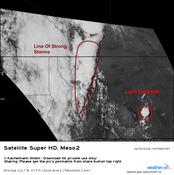
In the Northern Rockies, storms have formed in Montana ahead of a strong Pacific disturbance that moved onshore yesterday. The main line of storms in the area is producing lightning and heavy rain, along with gusty winds and small hail that are generally remaining below severe limits. Meanwhile, well southeast of the main line, a lone supercell has popped up in northeastern Wyoming, and is producing damaging winds and large hail in addition to torrential rain and lightning. The area of cumulus surrounding that storm indicates that conditions may be favorable for additional storm development as we move through the evening.
Track the storms with GOES-East satellite imagery, HD radar imagery, and lightning analysis. Click any one of the maps at the link to zoom into county level for a closer look. Or if you want more zoom flexibility, try custom zoom mode, available via the menus to the left of the image.
Storms will, as they tend to, decrease in coverage and intensity as the evening wears on due to the loss of energy from daytime heating.
-Jack
