Pair Of Strong Upper Level Disturbances To Bring Severe Storms To Different Parts Of The Country Today
Hello everyone!
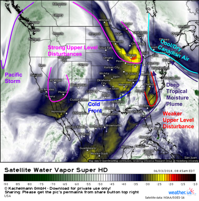
Today’s weather across the US will be driven by a pair of strong upper level disturbances, each of which will be responsible for severe thunderstorms and heavy rain. The first disturbance is moving through the Desert Southwest, while the second is located over the Great Lakes. That second disturbance has driven a cold front south through the Plains, where an unusually cool/dry day is expected today. Generally quiet weather is also expected across the West Coast, interrupted only by a few storms in the Northern Rockies as a Pacific storm approaches this afternoon.
As always, GOES-East water vapor satellite imagery is a great way to get a quick overview of all the factors that will go into today’s forecast. Our two strong disturbances are clearly evident, and become even more apparent on looped imagery. Deep tropical moisture is feeding into the Great Lakes disturbance, partly as a result of a weaker disturbance over the Carolinas. This will help to drive continued flash flooding concerns in the DC area as heavy rain remains a threat in addition to severe storms. The second disturbance over the Desert Southwest does not have a tropical moisture tap, so its primary threat will be severe thunderstorm activity over parts of New Mexico and western Texas.
Mid Atlantic/Southeast
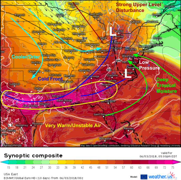
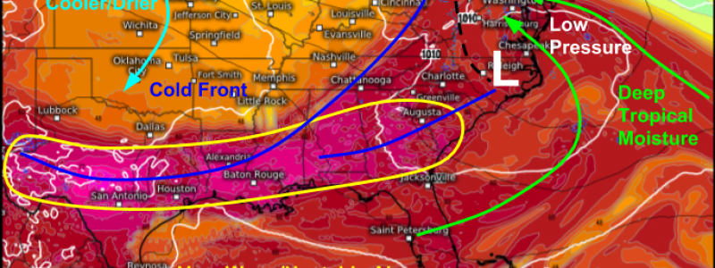
Here’s a look at the setup forecast across the Eastern 2/3 of the country this evening, as seen by the ECMWF’s Synoptic Composite map. The same general pattern we saw in GOES-East imagery above is expected to continue as tropical moisture streams northwest ahead of the strong disturbance in the Great Lakes, and a pair of surface lows connected by surface trough. The low and trough over the Mid Atlantic will be focus areas for heavy rain, while the cold front stretching through the Southeast into the Gulf Coast states will provide a focus for thunderstorm activity, some of which will be severe. Gusty winds will be the main threat from storms in these areas today, along with heavy rain and frequent lightning.
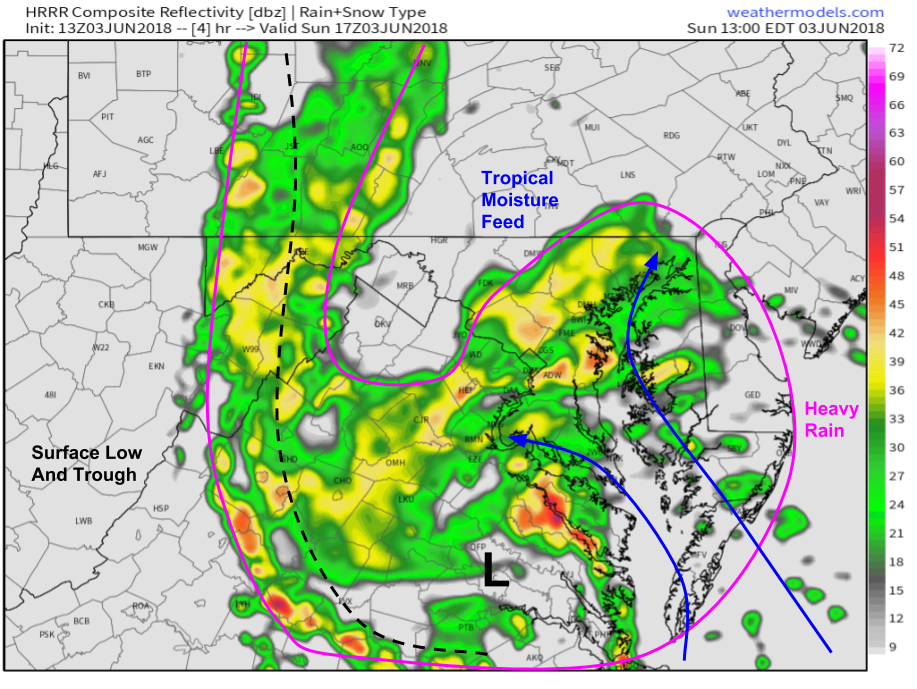
Here’s a look at the HRRR’s simulated radar forecast via weathermodels.com which shows areas of heavy rain today in the Mid Atlantic. Some of that rain will be steady in nature, especially the farther northeast you go, while some of it will be more convective, especially the farther southwest you go. However, even in areas where thunderstorms do occur, no severe weather is expected. The threats from storms today will be torrential downpours and frequent lightning, both of which can be just as dangerous as strong winds and large hail.
New Mexico/Western Texas
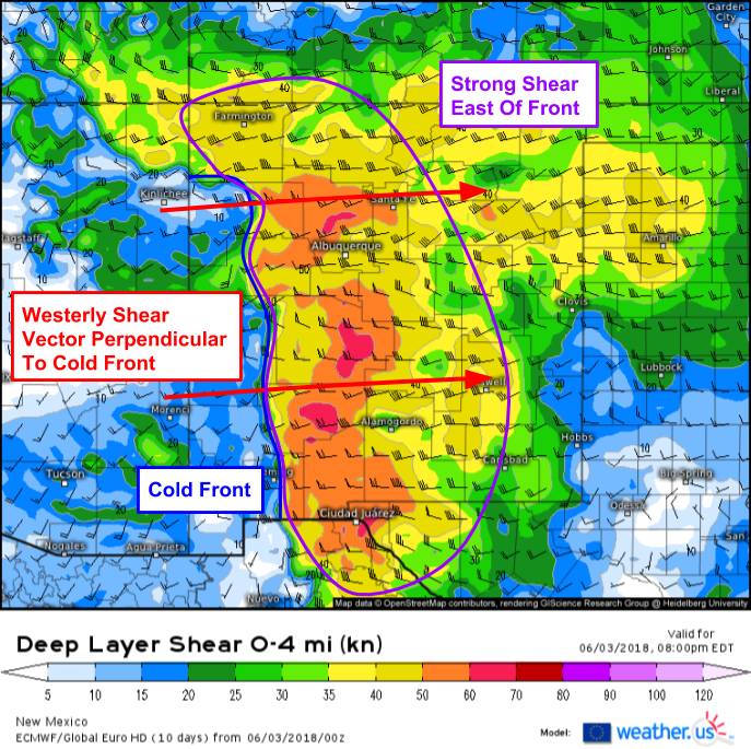
The disturbance moving through the Desert Southwest this morning will set the stage favorably for severe thunderstorm activity across New Mexico this evening. Low level southeasterly winds will be transporting moisture into the area from the Gulf of Mexico, while winds aloft will be out of the west-southwest due to the disturbance passing by to the north. The change in wind speed and direction with height, also known as wind shear, will help support severe storms that initiate on a cold frontal boundary located in the western part of New Mexico.
This map from the ECMWF shows the wind shear discussed above. East of the boundary, where there is a large contrast in wind speed and direction with height, strong shear is present. The shear vector, shown in barb format, is out of the west today. This is perpendicular to the cold front which runs along a generally N-S axis. A shear vector perpendicular to the boundary on which storms are expected to initiate is a sign that storms, at least in initially, are likely to be discrete in nature. Discrete storms moving through an environment with high rotational energy are more likely to produce all modes of severe weather including hail and tornadoes in addition to the more typical damaging wind threat.
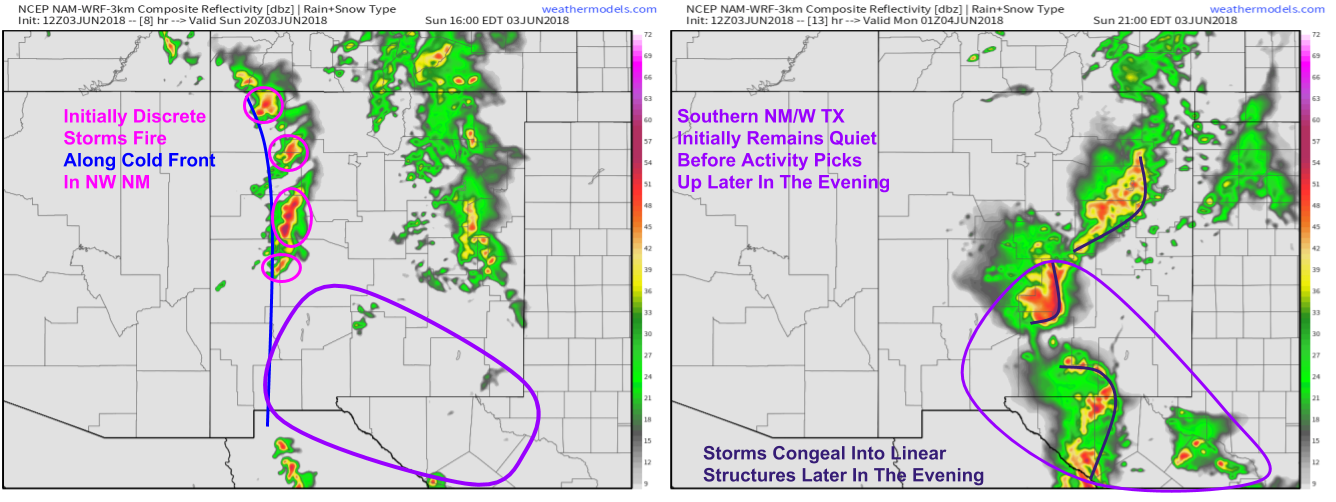
Here’s a look at simulated radar imagery via weathermodels.com for 2 PM MDT and 7 PM MDT showing the overall evolution of the storm setup. Initially discrete cells will form along the cold front, and some of those storms are likely to develop into supercells given the strong shear. Earlier in the day, activity will be focused in NW NM, before a transition to linear storm modes occurs across SE NM and W TX later in the evening. That transition in storm mode will also be accompanied by a transition in threats from all modes of severe towards a primarily damaging wind concern. All storms will bring torrential downpours and frequent lightning, regardless of their severe status.
Northern Rockies
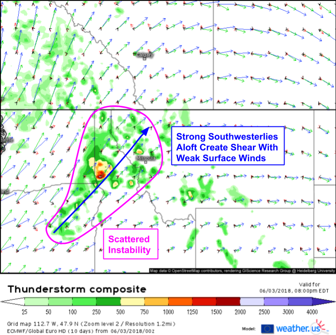
In the Northern Rockies, some instability is expected to develop ahead of an incoming Pacific storm. Upper level winds from that storm will bring wind shear to the area, and the combination of those two ingredients with a surface boundary in the area as well as terrain influences will result in scattered storm development this afternoon. Storms will pose primarily a damaging wind threat.
Elsewhere across the country, generally quiet weather will prevail across the Plains, West Coast, and New England. For more details on your local forecast, type your town into the search box on weather.us to get a complete look at your weather from the next few hours to the next 14 days.
For more details on the local forecast for ME/NH, check out this morning’s local blog post.
-Jack
