Several Areas Of Severe Thunderstorm Activity Expected Today
Hello everyone!
There are several areas to watch for severe thunderstorm activity today as a complex pattern evolves over the US. This post will briefly discuss what to expect from each round of storms, along with a quick look at some of the factors behind why the forecast what it is.
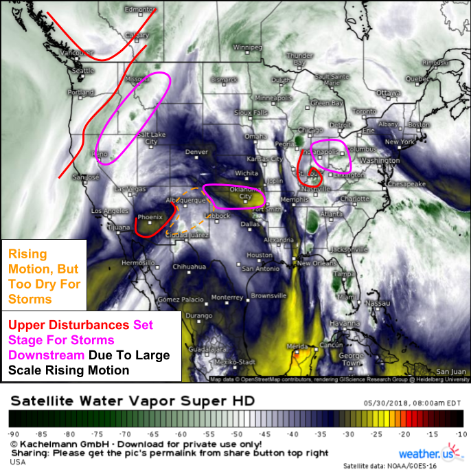
Before digging into each region, it’s always good to get the big picture with GOES-East water vapor satellite imagery. Upper level disturbances show up well on this satellite view, and areas downstream of those disturbances are set up favorably for thunderstorm activity. I’ve highlighted the three disturbances that will spark severe thunderstorms today. In addition to the areas highlighted above, a disturbance in the Gulf of Mexico will fuel thunderstorm activity over Florida and the Southeast though upper level winds there won’t be strong enough for widespread severe weather.
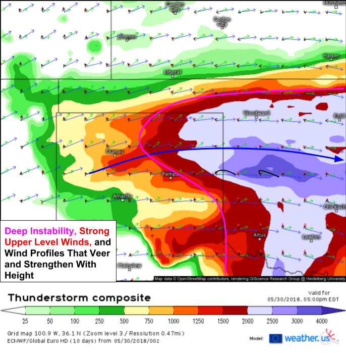
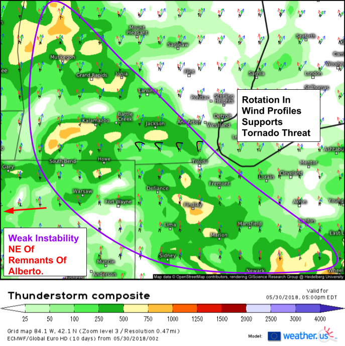
Most of the discussion below will center around our ECMWF Thunderstorm Composite product which displays many of the ingredients needed for severe thunderstorm formation in one convenient map. You can find the product itself here, and an explanation/tutorial video here.
Southern Plains
An upper level disturbance currently over Arizona will move east during the day today, emerging over the Plains this afternoon. As it moves onto the Plains, it will encounter a frontal boundary and area of very unstable air. This combination will lead to the development of strong to severe storms, initially in Southeastern Colorado where southeasterly winds have an upslope component to enhance rising motion. With winds aloft blowing parallel to the frontal boundary, a linear storm mode is expected with large hail and damaging winds being the primary threats. Note that while a linear storm mode is expected, wind profiles do strongly veer with height, so there will be plenty of rotational energy in the atmosphere. As storms move east this evening into an environment with more low level moisture, some tornadoes are possible in embedded mesovorticies on the leading edge of the line. Potential also exists for what’s known as a “tail end Charlie” which is a rotating storm that forms on the southernmost end of a line of storms like the one forecast tonight. Should such a feature develop, it would locally enhance tornado potential in Central Oklahoma on the southern edge of the highest risk area.
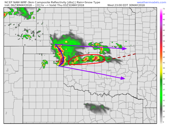
Simulated radar imagery for tonight (10 PM CDT) shows the linear storm mode mentioned above as a line of storms exits the panhandles of Texas and Oklahoma, moving into north-central parts of the Sooner state. The model develops some more discrete cells out ahead of the main line, which I’m skeptical of due to the weak nature of the front itself. Given such a weak front, it’s entirely possible that the only storm activity will be with the line itself. However, that line will pack a punch as it moves ESE. Look for damaging winds and large hail to pose serious threats into the overnight hours.
Map via weathermodels.com.
Northern Rockies
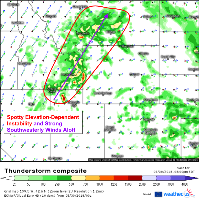
In the Northern Rockies, some elevation-dependent instability will exist today ahead of an upper level disturbance. This disturbance will provide large-scale rising motion in addition to enhanced mid/upper level southwesterly winds. Storms that develop in this area will be able to tap into some of those winds aloft, leading to a damaging wind threat. Storms will be triggered by terrain-induced differential heating. This occurs when the sun hits the summit of a mountain peak several hours before the surrounding valleys. The summit experiences several more hours of heating as a result, which leads to localized rising motion. As air moves up the mountain, it converges and continues to rise, which can eventually trigger thunderstorm development.
Lower Great Lakes
The remnants of subtropical storm Alberto continue their march north this morning. As the system moves along the Illinois/Indiana border, instability will develop to the storm’s northeast. Rising motion associated with the remnant low will help get storms going, and as they do, they will be able to tap into rotational energy brought to the area by the wind patterns associated with Alberto’s circulation. The storm continues to drive cyclonic flow at the surface, with winds spiraling counter-clockwise towards the center. Aloft, winds rotate in the opposite direction as outflow vents the system. The change in wind direction with height, also known as directional shear, is what will support the tornado threat. Due to the modest instability, no violent or long track tornadoes are expected, though even “weak” tornadoes are quite dangerous to those in the path.
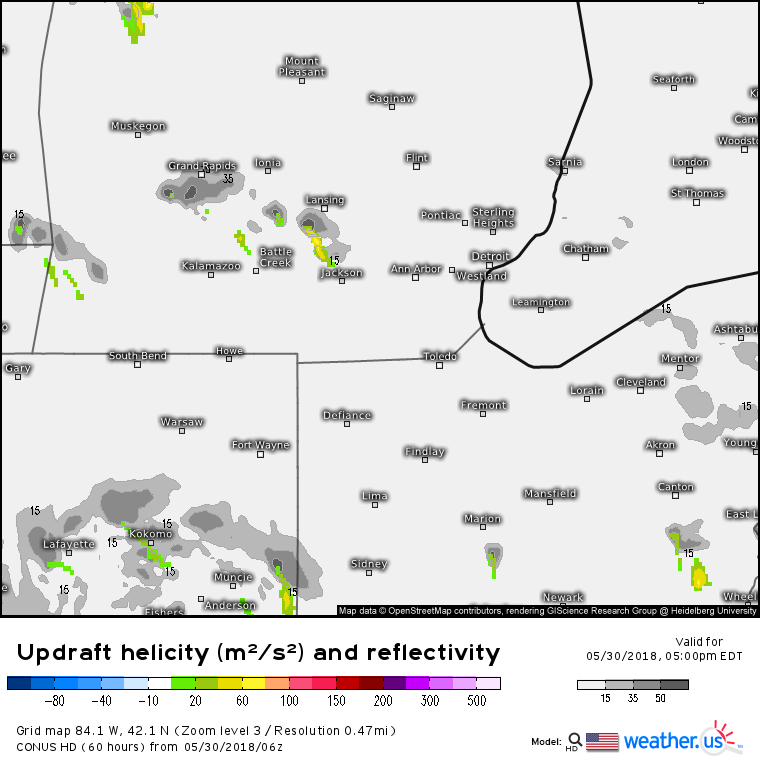
This map shows reflectivity (simulated radar) in gray, and a parameter known as updraft helicity in colored shadings. Updraft helicity is a measure of how much rotation there is in a thunderstorm’s updraft. The more an updraft is able to rotate, the greater potential there is for tornadoes. Note that it’s possible, especially out in the Great Plains, to see strongly rotating updrafts not produce tornadoes if there either isn’t enough moisture or rotational energy in the lowest few thousand feet of the atmosphere. While high UH values don’t guarantee tornadoes, the atmosphere does appear conducive to tornado potential from Ohio through SE Michigan this evening.
Track all of today’s storms with the GOES-East satellite, HD radar, and lightning analysis products we have at weather.us. For more model guidance, you can explore the options we have at weather.us for free, or the ever-expanding collection of products hosted at weathermodels.com for just $8/month if you sign up for a yearly subscription.
-Jack
