Subtropical Storm Alberto Strengthening This Evening
Hello everyone!
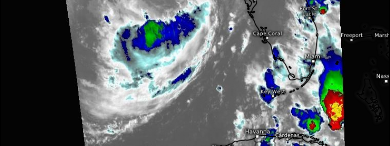
Subtropical Storm Alberto continues to move through the Gulf of Mexico this evening, and is strengthening as it does so. The storm’s appearance on satellite imagery is ragged and disorganized at the moment, but hurricane hunters have been investigating the storm this evening, and have found stronger winds compared to earlier in the day. The NHC has pegged the storm’s maximum sustained winds at 65 mph based on that data, with some additional strengthening possible before landfall on the Florida Panhandle tomorrow.
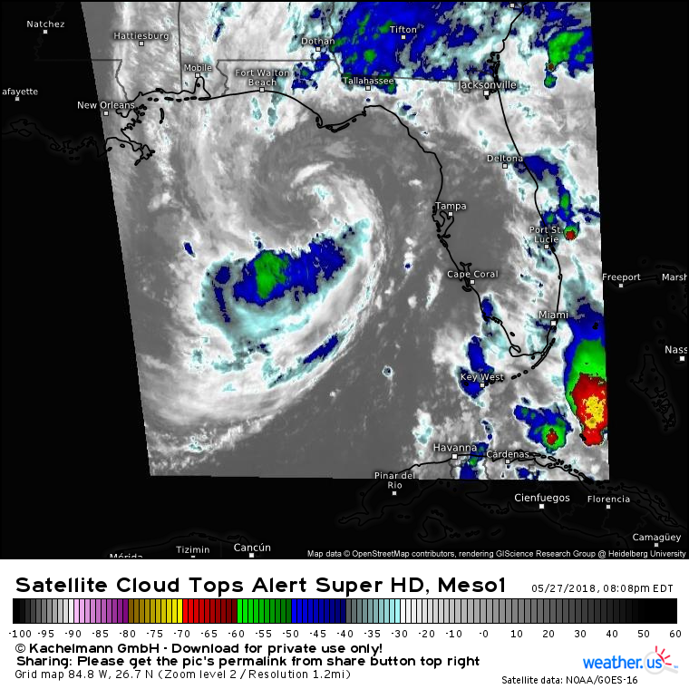
Here’s a look at GOES-East imagery of Alberto this evening. Its center is now well defined SSW of Tallahassee Florida, and shower/thunderstorm activity is working to wrap around the center both from the SW and the NE, though an abundance of dry air is trying to prevent that. The center itself is relatively devoid of convection this evening, but as the air cools tonight and the vertical temperature gradient between the warm Gulf of Mexico and the cooler nighttime air increases, thunderstorm activity should pick back up. As long as the storm’s thunderstorm activity remains displaced from the center of circulation, Alberto will remain a subtropical storm, though it’s possible it achieves fully tropical status if a sustained burst of intense thunderstorm activity can develop near the center tonight.
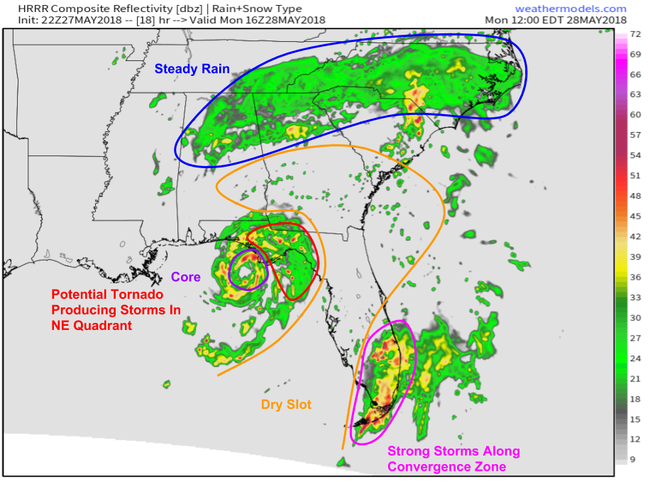
Here’s a look at the HRRR’s simulated radar map for noon tomorrow. As always, don’t use this product as a precision tool to pinpoint showers/storms, but instead use it as a general guide to larger scale features/patterns. The core of Alberto is clearly visible moving towards landfall on the Florida Panhandle. In the core, look for heavy rain and gusty winds, some of which may gust near hurricane force if current strengthening trends are able to continue. East of the center of circulation, onshore winds will push some Gulf water up against the coastline. While far from the storm surge impacts a major hurricane might bring, even a couple feet of water level rise will be enough to cause some minor inundation of particularly susceptible areas. Map via weathermodels.com.
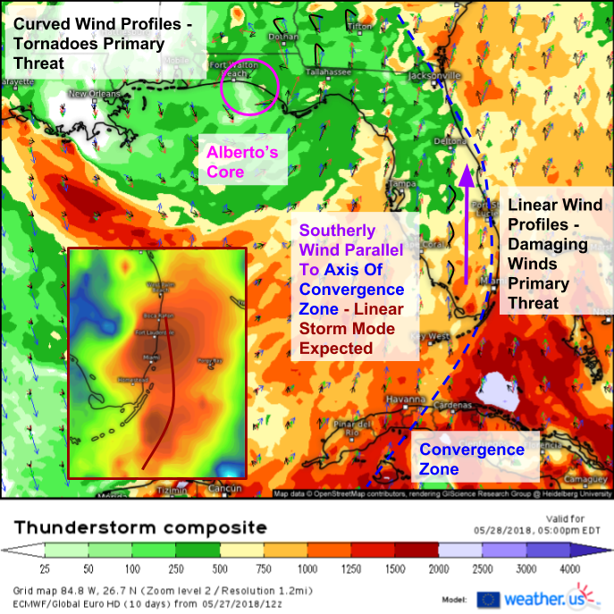
Here’s a look at the ECMWF’s thunderstorm composite map for tomorrow evening showing some of the severe weather hazards expected in addition to heavy rain and gusty winds from Alberto’s circulation itself. Storms on the eastern side of the system, forming along an area of convergence near Florida’s East Coast, will be the focus for severe weather as a line of storms is able to tap into unusually strong winds aloft. Winds in this area are primarily southerly, and change little in direction with height, so damaging winds will be the primary threat. A snapshot of the ECMWF’s simulated satellite imagery for 8 PM EST confirms the linear storm mode that can be reasonably inferred from the unidirectional wind profile that’s oriented parallel to the boundary that provides the trigger mechanism to actually get storms firing.
Farther north, winds will be changing much more with height closer to the center of Alberto’s circulation. In this area, just to the northeast of the center itself, severe weather will also be possible. Short-lived tornadoes will be the primary threat here, though it’s important to note that all tornadoes are dangerous, even those that aren’t long-track headline makers.
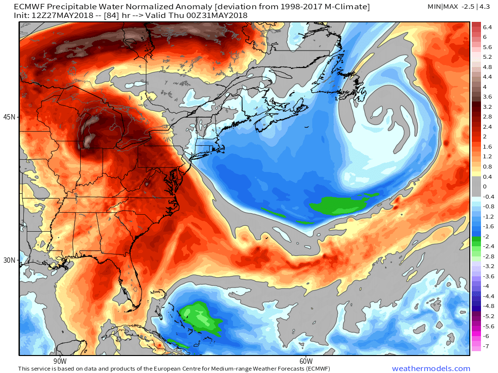
As Alberto moves north in the next few days, it will lose the Gulf of Mexico’s warm waters as an energy source, but its plume of moisture will remain intact. This map shows a large plume of unusually moist air spreading north into the Great Lakes by Wednesday, with steady rains expected to continue even long after the storm’s winds die down. Map via weathermodels.com.
Follow both @WeatherdotUS and my personal account @JackSillin on twitter for more updates on this storm in the coming days. Also keep an eye on the latest developments with the stormtracking tools we have at weather.us including GOES-East satellite imagery, HD radar imagery, lightning analysis, and forecast model output both in map form and in town-specific form. Click any of our maps to zoom in, and use the menus to explore more parameters and options.
-Jack
