Tropical Disturbance To Join With Larger Pattern To Bring Beneficial Rains To Parts Of The Southeast And Mid Atlantic
Hello everyone!
Showers are already ongoing from Southern Florida into Southern New England this morning as tropical moisture flows northward from the Gulf of Mexico. These showers will continue over the next several days, bringing beneficial rains to areas that have been abnormally dry over the past several weeks. This post will discuss what’s behind these rains, what to expect from them over the next few days, and when to expect the pattern to break.
GOES-East water vapor satellite imagery this morning (click for satellite imagery tutorial video) shows several of the features key to the persistent rains. On the synoptic (large/100’s of miles) scale, an upper level trough/low is located over the Southern Mississippi valley, and an unusually strong Bermuda high is located near Bermuda, as we would expect. Clockwise flow around the high and counterclockwise flow around the low are combining to create southerly winds from the Caribbean through the Southeast and up into the Mid Atlantic. This is the pipeline of tropical moisture responsible for the rains.
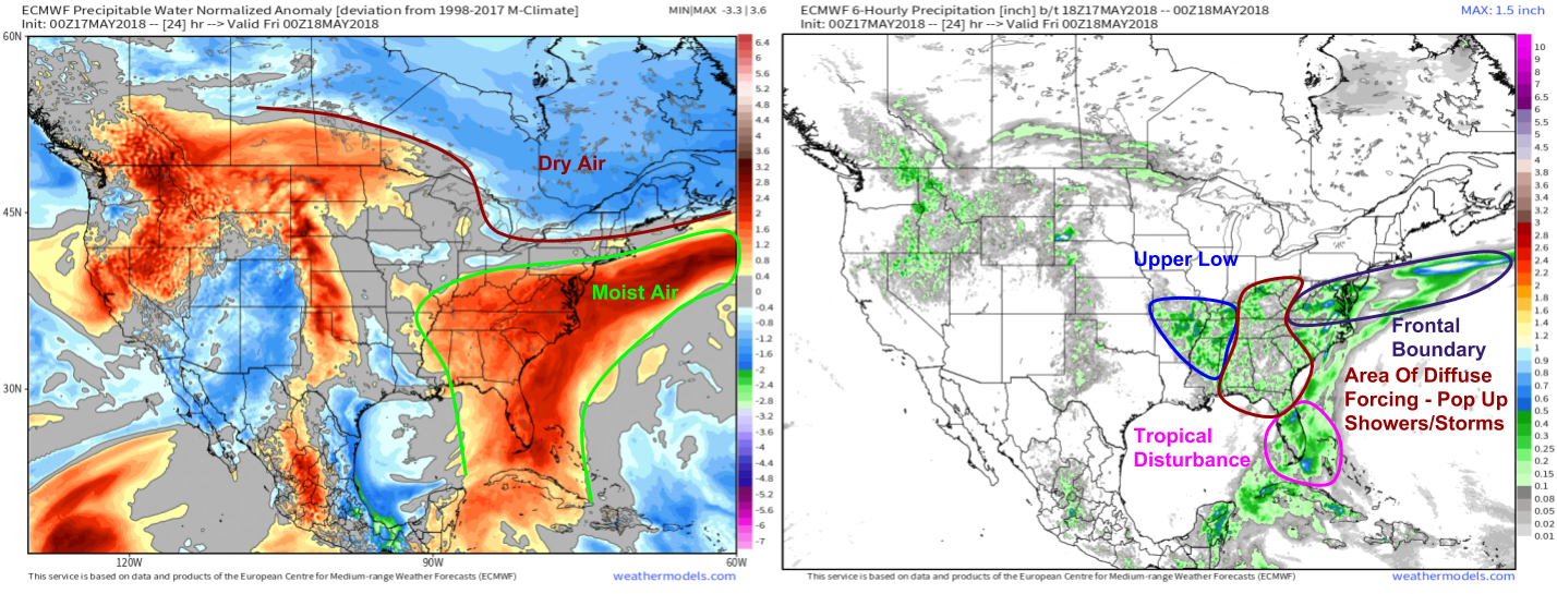
The map on the left is what’s known as the precipitable water anomaly. Precipitable water is a measure of how much rain would fall if all the moisture available in the atmosphere at any given point were to suddenly condense. Higher PWAT values correspond to increased moisture. The area of unusually high PWAT values (red shading) corresponds to the moist tropical airmass forced northward by the features discussed above.
The map on the right is the 6 hourly precipitation forecast for this afternoon (between 2 PM and 8 PM, how much rain is expected to fall). This shows areas of enhanced values near several forcing features, needed to squeeze the moisture out of the atmosphere. The first is the upper level low discussed above, which is producing lift and shower/thunderstorm activity over parts of Mississippi, Arkansas, and Missouri. Second, a tropical disturbance is helping spark thunderstorm activity over the Florida peninsula. Finally, a large area of cool high pressure over Canada has pushed a frontal boundary southward into the Mid Atlantic. You can see on the precip map how each feature is helping to wring some of the moisture out of the atmosphere, enhancing precipitation totals above the “baseline” pop up shower and thunderstorm activity the model sees developing from places like the Florida Panhandle north to Kentucky.
Both maps are via weathermodels.com.
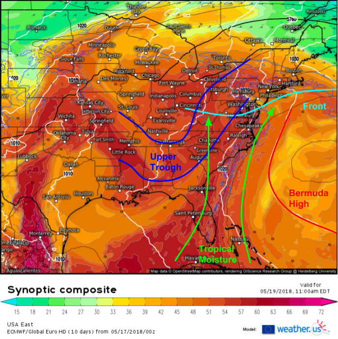
Looking ahead, this same general pattern will still be around by the time we get to Saturday, shown on this ECMWF synoptic composite map (click for synoptic composite tutorial video). The southward dip in the black lines (500mb heights) shows the upper level trough over the Ohio Valley, the westward bulge in the white lines (sea level pressure) shows the Bermuda High off the Southeast Coast, and the eastward kinks in the surface pressure fields over the Mid Atlantic highlight the continued presence of a frontal boundary there. Meanwhile, the shading (theta-e, a measure of heat/moisture) shows a warm and moisture laden airmass continuing to stream northward from the tropics. As a result, look for the same rainy pattern to continue into the weekend.
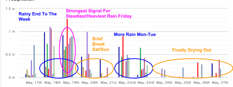
Here’s a look at our Forecast XL product for Philadelphia (click for Forecast XL tutorial video) showing the timeline for rain over the next ten days. The current rainy pattern will last through the end of the week, with tomorrow likely seeing the steadiest/heaviest rains (notice all models are in agreement for between .5″ and 1″ of rain, which indicates high confidence in steady precip). A brief break is forecast for the weekend as the atmosphere ‘reloads’ for another rainy stretch to start the week.
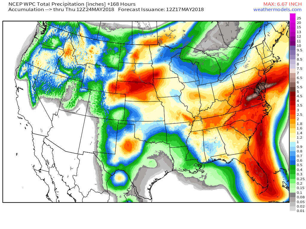
This map, from the weathermodels.com Model Lab, shows how much rain the National Weather Service’s Weather Prediction Center expects to fall over the course of the next week. Notice the local maxima over Florida, due to the tropical disturbance, over the Mid Atlantic, due to the frontal boundary, and over parts of SE MO/TN/MS due to the upper level low. While the rain will mostly fall over a long enough period of time to preclude any major flooding issues, watch the DC area for problems as more rain falls on already water-logged soil. Some rivers in the DC area could reach moderate flood stage by the weekend.
The pattern will break down midweek next week as a trough builds into NE Canada, bringing drier NW flow to the Northeast and Mid Atlantic.
For more details on your local forecast, check out our Forecast Overview page, with information specifically for your town. To access the Forecast Overview information, simply type your town into the search box on our homepage weather.us.
For more details on what to expect across ME and NH today, check out my local forecast post: https://forecasterjack.com/2018/05/17/slowly-improving-weather-today/
-Jack


