Storm Brings More Severe Weather To Parts Of The Southeast Today
Hello everyone!
The storm system that brought intense severe thunderstorms, including several damaging tornadoes, to northern parts of MS, AL, and GA yesterday will continue to move eastward today, with severe storms expected along the coastlines of NC, SC, and GA, as well as areas farther south into FL. The storm’s portfolio of hazards will diversify today as it begins to run into a cold dry airmass over the Northern Mid Atlantic. This will result in wintry weather developing over parts of the Northern Mid Atlantic with some snow, sleet, and ice expected. However the real winter storm in this area will arrive tomorrow once additional disturbances make their way towards the coastline and join forces with what’s already in place. I will have a blog post detailing that forecast this afternoon/early evening. In addition to this storm, we also have a significant weather event beginning across the West today as an Atmospheric River gears up to drop a foot of rain on parts of Southern California. I will have a blog post discussing that system later this morning.
Here’s a look at GOES-East satellite imagery (what’s that?) which shows all the various elements that will be important to driving this storm system today. Yesterday’s disturbance has sheared out over West Virginia last night, and last night’s storms are now moving off the Carolina coastline. Meanwhile, another disturbance is driving southeast out of the Southern Plains, and there are clear signs of rising motion out ahead of it. As this disturbance and rising motion catches up to surface moisture ahead of a cold front in SE SC/far SE GA/Eastern FL, the stage will be set favorably for severe thunderstorm activity. Meanwhile, an additional disturbance will be dropping into the back of the trough carved out over the Southeast, and will help kick the storm up the coast a bit, where it will run into a cold/dry airmass over the Northeast.
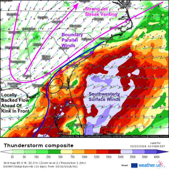
The ECMWF’s thunderstorm composite map (what’s that?) provides an excellent framework for analyzing severe weather threats. Between the instability shading (CAPE) and the vertical wind profiles, we can see where storms are likely to form, as well as what the storm mode is likely to be, and thus which threats are most significant for any given area. The overall setup features a cold front moving southeast towards the coastline, and a wave of low pressure trying to develop along that front as the disturbance discussed above approaches. It’s ahead of the little kink in the front that represents the wave of low pressure that surface winds will be locally “backed” or out of the south/southeast rather than southwest. When low level winds are out of the southeast, there’s more rotation in the atmosphere to support rotating thunderstorms.
It’s also important to note how mid/upper level winds are blowing in relation to the “boundary of initiation” which is the forcing mechanism for thunderstorm development. Notice how along the SC coast, winds are blowing parallel to the boundary, while in SW GA and off the FL coast, winds are blowing more perpendicular to the boundary. This means that a line of storms is likely to form in the northeastern part of the severe threat area, while discrete supercells are more likely to the south and west. However, even in the northern part of the FL peninsula, where the shear/boundary orientation is favorable for supercells, surface winds are still southwesterly which will limit low level rotation a bit. That means that while tornadoes certainly can’t be ruled out, the threat will be more limited in both scope and intensity today.
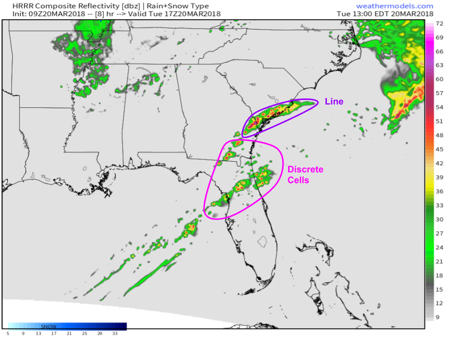
This HRRR simulated radar image shows the practical result of the processes discussed above. Storms are forecast to orient themselves into a line across parts of the GA and SC coastlines, while farther southwest in GA and into FL, storms will be more of the discrete variety. Both storm modes will be quite dangerous, just in different ways. The line will impact more people (less sporadic in nature) with damaging winds and large hail being the main threats. The discrete cells won’t impact everyone, and some folks will make it through with little more than some raindrops on the roof, but their ceiling for impacts is much higher as they are more likely to produce tornadoes along with hail and damaging winds. All storms will produce dangerous lightning and torrential downpours. Map via weathermodels.com.
Once storms form this afternoon, track them with the wide array of tools we have at weather.us. Watch small cumulus clouds grow into towering thunderstorms with 1 minute GOES-East satellite imagery https://weather.us/satellite/georgia/satellite-superhd-1min.html#play, find the cores of the strongest storms with HD radar imagery https://weather.us/radar-us/georgia/reflectivity/KJGX.html#play, and see if they’re spinning with HD velocity data https://weather.us/radar-us/georgia/velocity/KJGX.html#play. Finally, watch current observations to keep tabs on the building instability, as well as the location of important features such as the cold front as it moves east. Current temps https://weather.us/observations/temperature-f.html dew points https://weather.us/observations/georgia/dewpoint-f/20180320-1100z.html and wind direction https://weather.us/observations/georgia/wind-direction/20180320-1100z.html will be the parameters that will be most important today. Click the refresh button at the top left of the image to get the latest data. Click any of the maps at the links to zoom into county level for a closeup look at what’s happening in your neighborhood.
Storms will move offshore this evening as the front sweeps east.
I will have a post detailing the California Atmospheric River event later this morning, and a post detailing the Mid Atlantic/Northeast winter storm this afternoon/evening. In the meantime, check your forecast whenever you want at weather.us, and keep tabs on all the latest model runs at weathermodels.com.
-Jack


