
Major Nor’easter To Bring Drenching Rain, Heavy Snow, High Winds, And Major Coastal Flooding To Parts Of The Northeast Friday
Hello everyone!
A major coastal storm is expected to develop tomorrow night off the East Coast as powerful upper level energy runs headlong into deep tropical moisture. Impacts will range from heavy snow to torrential rain to ferocious winds to storm surge inundation in low lying coastal areas. I’ll break it all down below, as always not just what to expect, but why. 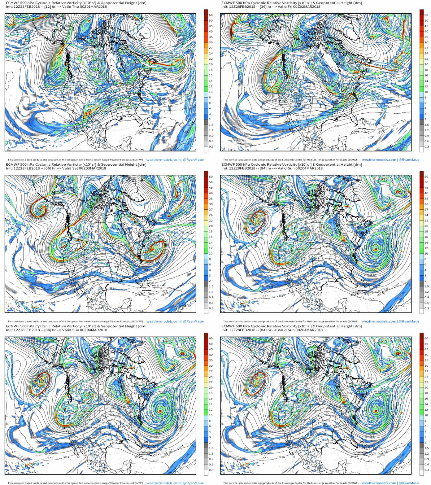
While I typically like to start off posts on large storms like this with a look at the current WV satellite imagery, the features that will end up forming our storm are actually fairly unimpressive this evening, and do not do the system justice. This loop of mid/upper level energy (vorticity) from the ECMWF via weathermodels.com does a much better job highlighting not only where our various disturbances are this evening (first frame), but also where they’re going and how features that seem quite benign tonight become far from it by tomorrow. Notice at the beginning of the loop the disturbances in Alberta and New Mexico. Those are the two disturbances that will come together to form our storm, but it’s not until they meet over Pennsylvania that the system can really develop. However, once they do meet, the system really will take off as you can see by the explosive deepening of the upper level low and associated rapid increase in energy (red shadings).
As that energy consolidates and approaches the coast, surface pressures offshore will plummet as our storm develops. This is a map of the three hour change in pressure between 1 am and 4 am Friday morning according to the ECMWF’s forecast. Notice the very large area of pressure falls off the coast as the storm rapidly ramps up. Also notice the large expanse of those pressure falls. They’re not concentrated in one small area, but rather spread out over a wide swath of ocean. One of the things that will make this storm so impactful will be its sheer size, and that will be a factor right from the beginning.
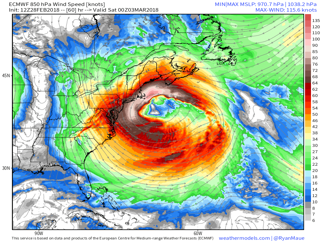
One common way to measure the size of a storm is by its wind field, which consists of the area where winds are influenced solely by the storm system. In this storm’s case, the wind field stretches from James Bay all the way to the Central Atlantic, a distance of over 2,000 miles. This large wind field is most important for the coast of Massachussets because the very long easterly fetch from the waters south of Atlantic Canada all the way to the coast will pile up quite the volume of water, as well as massive waves that will batter the shorelines for several days.
Map via weathermodels.com.
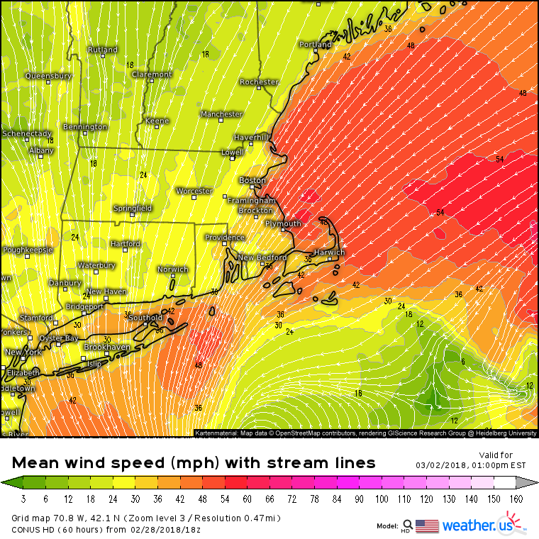
Wind streamlines from the NAM model show why coastal flooding will be such a huge issue. Winds from the Northeast will pile water up against the MA shoreline from Cape Cod to Cape Ann. Sustained winds of tropical storm force are expected, with gusts over hurricane force entirely possible especially on exposed parts of the Capes. Unfortunately, this storm coincides with astronomically high tides and storm surge inundation of several feet is likely in low lying areas. Be sure to heed the advice of any local officials when it comes to evacuations, as some voluntary orders have already been issued for the most vulnerable areas.
This loop of lower level winds from the ECMWF model via weathermodels.com shows an additional factor that will make the coastal flooding situation even worse. The loop runs from tomorrow afternoon through next Tuesday evening. That’s six days from now, and winds are still out of the East across a long fetch in the North Atlantic, aimed at MA. The storm, while it will move away from the immediate coastline, will linger not too far offshore for several days, and because the wind field is so large, coastal problems will continue even after the sun comes out.
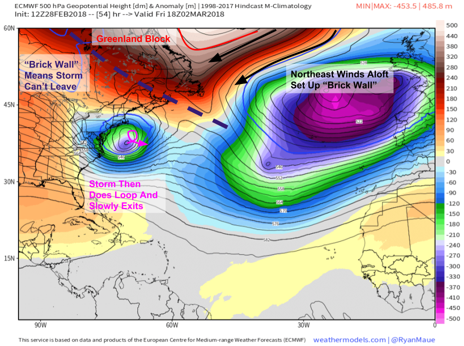
Why is the storm so slow to exit? This map via weathermodels.com holds the answer. Notice the area of high pressure over Greenland shown by closed high height contours and very positive height anomalies. Northeast winds will set up on the south side of this high, as clockwise flow takes over. This northeast flow will set up a brick wall of sorts that will prevent the storm from exiting quickly into the Maritimes like most Nor’easters. Instead, the storm will meander in the Western Atlantic as it ever so slowly spins down before the Brick wall is broken by another storm incoming from the west across North America next week.
The other result of that long easterly fetch will be very large waves. This ECMWF forecast shows wave heights over 30 feet just off Cape Cod, with 10-20 foot waves running right up to the rest of the MA coast. While breaking waves may not match these heights exactly, the fact remains that pounding wave action will further exacerbate coastal flooding issues in Coastal MA tomorrow, and damage to near-shore structures should be considered a viable possibility at this point.
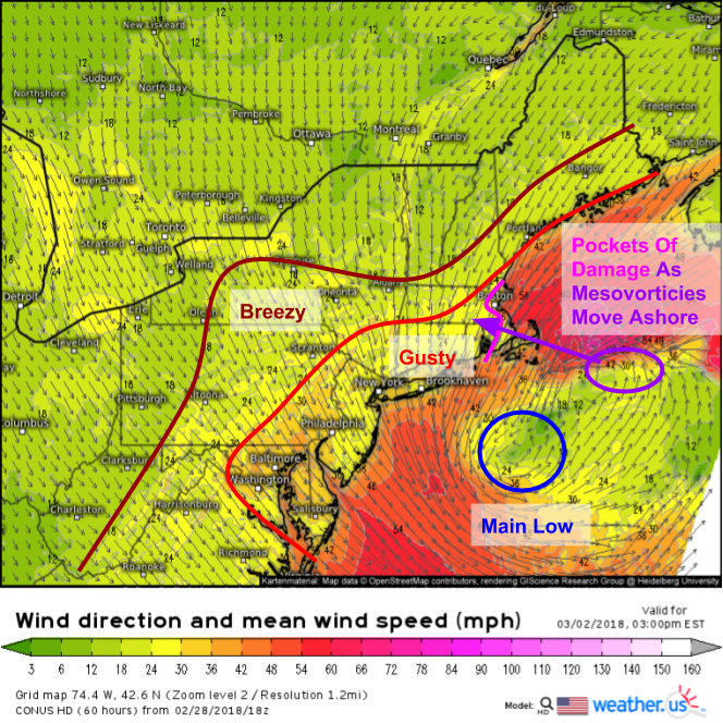
Strong winds won’t just cause problems via coastal issues, the intensity of this storm means that the winds will be dangerous of their own accord in certain areas, namely the MA coastline. As the main low drifts slowly southeastward off of Long Island, mesoscale vorticies (circulations) will rotate around the storm’s northern side and move onshore, locally enhancing winds to damaging levels in places like Cape Cod. Gusts along Cape Cod and Cape Ann could top hurricane force for a time on Friday afternoon. Breezy and gusty conditions will extend much farther from the storm’s center due to the large wind field discussed above.
In addition to high winds and major coastal flooding impacts, this storm will also produce heavy precipitation.
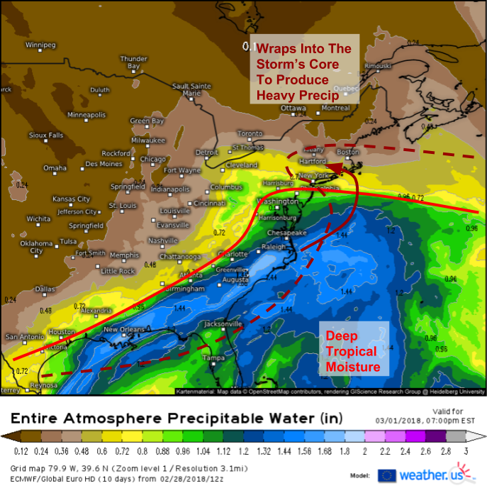
ECMWF precipitable water (moisture) forecasts show a very deep pool of tropical moisture lurking off the East Coast tomorrow evening. As the storm develops and its circulation matures, that moisture will get wrapped around the back side of the low, and will be available to produce heavy precipitation as dynamics intensify. Because the circulation will mature so quickly, winds will turn out of the east through much of the lower atmosphere, which will flood that layer with warm marine air as opposed to cold Arctic air from the north. The result will be that most of the heavy precipitation across New England will fall as rain, at least initially. As dynamics intensify though, a change to snow is expected from west to east. Areas closer to northerly winds and colder air such as Western NY will see snow closer to the start of the event.
Here’s a look at the NAM’s simulated radar forecast via weathermodels.com showing these processes in action. A pipeline of warm, moisture laden air crashes into New England with torrential downpours but overwhelming warmth. Farther west, cold air will support snow in Western New York with heavy precipitation near the boundary of the two airmasses helping to dynamically cool the atmosphere enough to support snow. That transition to snow will slowly work its way east through the day, though it will be hard for even the strongest dynamics to overcome the screaming low level jet in places like eastern MA.
In that heavy band of rain over MA, watch for some flooding concerns as total rainfall amounts could approach several inches, and much of that will fall in a short time.
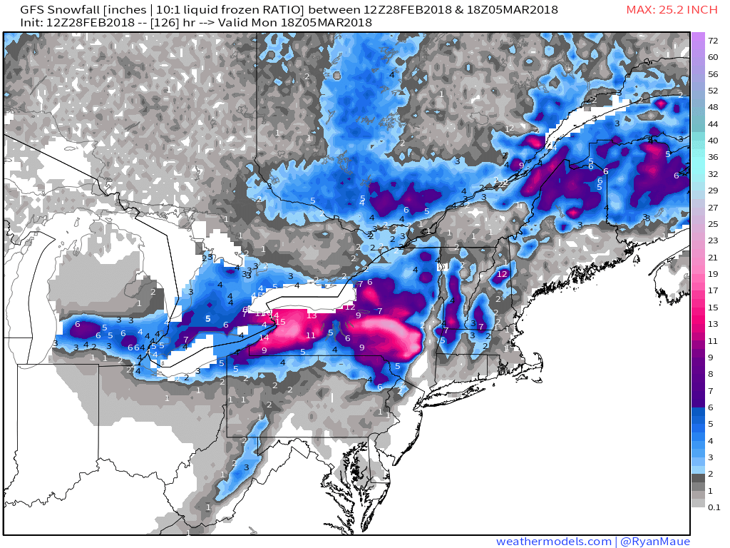
How much snow should you expect? This map from the GFS via weathermodels.com, while not perfect, gives a fairly good approximation in my opinion. The jackpot region will be Upstate New York right along the Thruway from Buffalo east to the Mohawk Valley. In this area, over a foot of snow is a distinct possibility. Lighter amounts are forecast to the south across Pennsylvania. Farther east, snowfall will be highly terrain dependent with 6-12″ in the Berkshires as well as the mountains of SW NH. In the few miles between those two areas of higher terrain, the CT river valley meanwhile should expect no more than 1-3″ as the storm pulls away on Saturday. Given uncertainties as to the placement and intensity of that heavy precip as well as the effectiveness of the dynamic cooling vs the low level jet, snow remains the most uncertain part of this forecast, so keep checking our forecast products at weather.us as well as NWS forecast information for the latest tomorrow as we continue to iron out the details.
Precipitation will wind down as the storm slowly drifts southeast on Saturday, though gusty winds and coastal concerns will continue.
-Jack






Nice Job!