Developing Storm To Bring Flash Flooding, Severe Storms, And Heavy Snow To Parts Of The Mississippi Valley Tomorrow
Hello everyone!
Today brought a wide assortment of active weather to various parts of the US, all of which I discussed in this morning’s update. Tomorrow will be even more active, with a high-end flash flood threat leading headlines along with widespread severe weather and heavy snow. This all is being fueled by a storm set to form tonight in the Southern Plains before tracking NE towards the Great Lakes. I’ll dig into each of these threats and explain not just what to expect from them, but why the forecast is what it is.
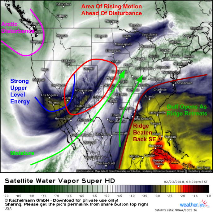
GOES-East WV satellite imagery (what’s that?) shows each of the key elements of this system evolving this afternoon. Strong upper level energy is moving east across the Desert Southwest, and strong rising motion is noted out ahead of it. This rising motion will strengthen and expand east as the disturbance moves towards the Western Plains tonight. The powerful Southeast ridge that brough temps in the 70’s to the entire East Coast from Florida to Maine on Wednesday has been knocked back towards the Bahamas, and as a result, the Gulf of Mexico’s moisture supply is now available to be tapped by the system. This moisture will join moisture from the tropical East Pacific to ensure plenty of fuel for heavy rain tomorrow. Finally, an Arctic disturbance is diving through the Pacific Northwest and will help to further amplify the trough in the Western states as the Las Vegas disturbance ejects east. This reinforcing effect will help keep our high amplitude flow pattern alive, which will support active weather and strong storm systems over the next few days.
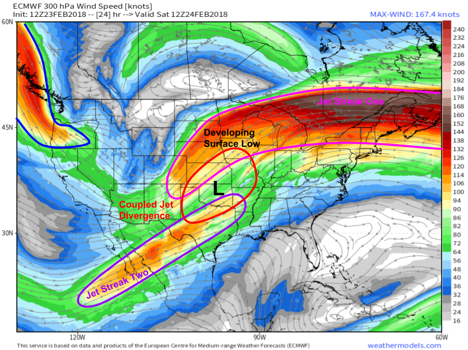
This ECMWF 300mb wind forecast from weathermodels.com shows plenty of jet-level support for this system’s intensification tomorrow afternoon. Two jet streaks are noted over the Central US, with a third entering the Pacific Northwest. The right entrance region of the first jet streak is co-located with the left exit region of the second, which means there will be a region of coupled jet lifting in the Plains tomorrow afternoon. This happens to be located directly over our developing surface low, which will steadily intensify during the day. The Pacific Northwest jet streak will be diving south and touching off an equal and opposite response downstream. In weather, not only does what goes up come down, what goes down also has to come up at some point. The jet diving south in the Pacific NW will force a northward bump in the jet over the Plains, which will help amplify this system and make sure it doesn’t just slip east with little consequence.
Map from weathermodels.com.
This GIF from weathermodels.com showing the ECMWF’s 850mb (~5000ft) wind forecast from tomorrow morning through Sunday morning shows a rapid rampup of the low level jet during that time as a result of the coupled jet lifting over the Plains. Notice how the jet first accelerates towards that area at the beginning of the loop before moving NE as the jet streak moves in the same direction. Also notice the large high pressure system centered near Bermuda. Southerly flow on the west side of the Bermuda high will contribute to strong moisture advection from the Gulf of Mexico up into the Mississippi valley tomorrow. This will be a crucial ingredient to both our severe weather and flash flood threats.
Here’s the ECMWF’s forecast for total precipitation between now and Sunday morning. Notice the wide swath of over 1″ of rain from NE TX through western PA. Flooding is possible anywhere in this area, as that rain will fall in a short period of time. The greatest risk for flash flooding will be from Arklatex up the Ohio River into NW Kentucky and Southern IN/IL/OH. An additional 2-4″ of rain is expected here, with localized amounts potentially much higher than that. This is on top of all the rain that has already fallen this week, which makes what would typically be a manageable rain event a major flash flood threat. So what’s behind such torrential rain?
Map from weathermodels.com.
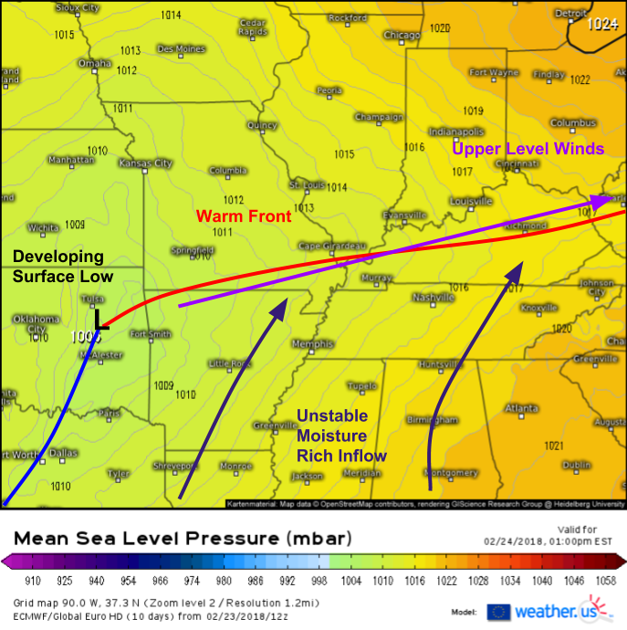
Here’s the ECMWF’s sea level pressure forecast showing one of the reasons why this flash flood threat is so severe. A well defined warm front is noted extending from our developing surface low in Eastern Oklahoma through Southern MO and into Kentucky. Other ECMWF forecasts show upper level winds blowing along the same WSW-ENE axis as the warm front, meaning that we have what’s called a “boundary parallel shear vector”. Storms move down the shear vector, which is the the sum of all the wind vectors within the layer the storms exist in (generally between the surface and four miles up). This means that storms that form on the warm front won’t move off the boundary, but instead will remain “training” over the same areas repeatedly. Storms that move into an area that has already seen storm activity once in a given day are generally known to weaken, but earlier we discussed the rapidly developing low level jet in this area. That LLJ will keep storms moving along the warm front supplied with a constant stream of fuel, even as they move over the same areas again and again. The setup will only fall apart once the surface low can become strong enough to force the warm air northward against the suppressive influence of strong Canadian high pressure to the northeast. This will happen tomorrow evening, but not before quite a lot of rain falls in areas that can’t handle too much more after this week’s deluge. Expect widespread flash flooding issues in these areas and remember never drive through flooded roadways, you never know how deep the water is, or even if the water has caused damage to the road itself.
Track all the storms tomorrow with our HD radar products that let you see a state level overview, or county level detail depending on what you’re interested in. Click on the state level maps to zoom into county level, or use the menus to navigate. You can also use the blue buttons at the top of the image to change the radar view, and access products such as velocity data, storm tracking, and lightning analysis.
Heavy rain won’t be the only threat from thunderstorm activity tomorrow afternoon/evening. Severe weather is also expected to impact a wide swath of the Southern MS Valley as well as the Western OH Valley.
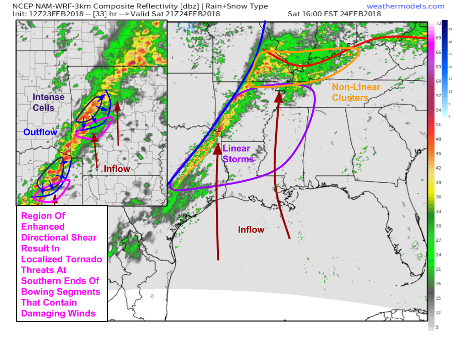
These simulated radar maps from the 3km NAM model via weathermodels.com show strong/severe storms developing from NE TX through Arkansas and into parts of SE MO/S IL/S IN/NW KY tomorrow afternoon/evening as the warm front discussed above lifts north and the cold front approaches from the west. Strong forcing along the cold front will favor a linear storm mode for most of the area tomorrow, which typically favors damaging winds. Indeed, damaging winds will be the main threat with these storms, however storm-scale dynamics (those that occur on the scale of a single storm as opposed to a region (mesoscale) or country/continent (synoptic scale)) will favor localized tornado threats even along the line. Given marginal instability, it’s unlikely that this line of convection will be a uniform line. Instead, it’s much more likely to have more and less intense segments. The more intense segments are likely to “bow out” due to their becoming outflow-dominant quickly in a low instability environment. As they “bow out” (transition into a structure that resembles a bow ready to fire east), outflow winds will locally turn perpendicular to the larger scale inflow. This localized increase in directional shear (change in wind direction with distance or height) will support rotational components to some storms that could produce tornadoes.
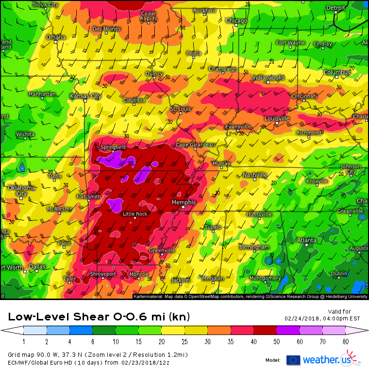
This threat will be greatest in NE TX and Arkansas as ECMWF guidance shows low level shear (shown on the map above) maximized in these areas. Farther south, the inflow component to the wind isn’t as strong, or as backed (including an easterly component), which means there will be less low level directional shear, and thus the threat will be more oriented towards damaging straight line winds as opposed to tornadoes.
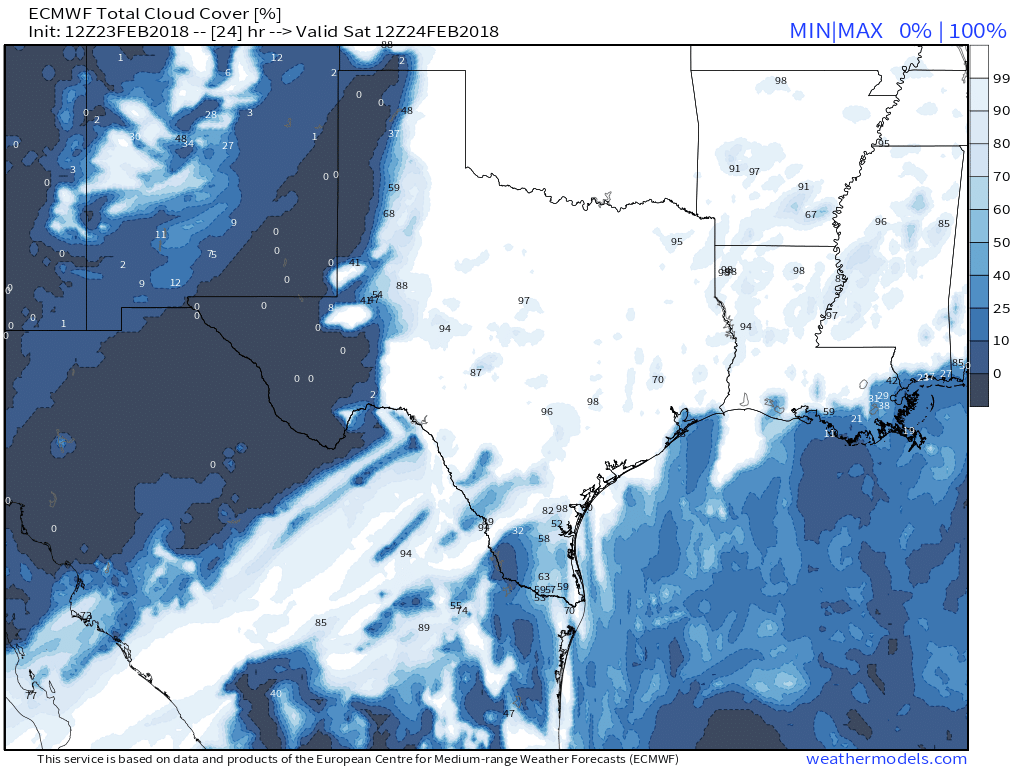
This ECMWF total cloud cover map from weathermodels.com shows overcast skies across our entire severe threat area tomorrow morning. The lack of sunshine will be the inhibiting factor as far as severe weather goes, because without the warming effect of direct sunshine, there won’t be as much of a vertical temperature gradient. Instability is determined in part by the vertical temperature gradient, and given the same temps aloft, it’s important to maximize surface temps to achieve the maximum gradient for the most instability. It’s hard to do that with overcast skies, and thus the lack of instability becomes our limiting factor tomorrow. While it won’t prevent widespread severe weather threats, it will keep this system from being any type of high-end “outbreak” of severe weather. Be sure to check our GOES-East visible satellite imagery often tomorrow in this area to monitor the progress of any sunny breaks. If the sun does pop out in any of these areas, even for an hour or two, that would greatly enhance the severe threat!
Storms will weaken as they move east tomorrow night.
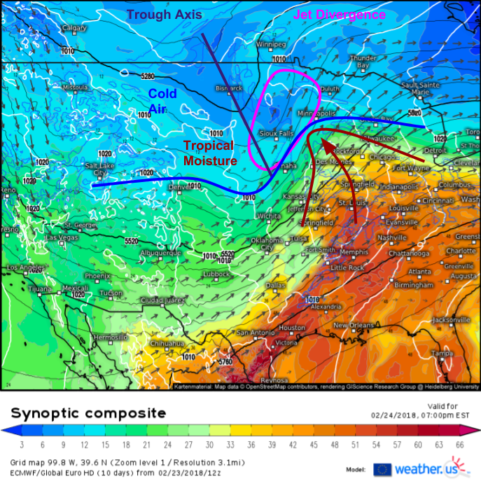
While thunderstorm activity brings a multifaceted set of threats to parts of the Mississippi and Ohio valleys, snow and ice will be concerns on the cold side of the developing storm as it moves from Eastern Oklahoma northeast towards the Great Lakes. The ECMWF’s synoptic composite map for tomorrow evening shows several key ingredients lining up for a band of heavy snow in the Northern Plains (curious about what the synoptic composite shows and how to use it? Check out this video). Tropical moisture is surging north and northwest around our developing low and into a cold airmass. The jet streaks discussed earlier will by this time have merged, with the left exit region located over the Sioux Falls-Minneapolis corridor. The divergence from this jet, the forcing from the advancing mid level trough axis, and the warm air rising over the cold air will combine to bring plenty of rising motion in this area, and the moisture moving in from the Gulf will enable that lifting to produce snow in a cold airmass northwest of the low.
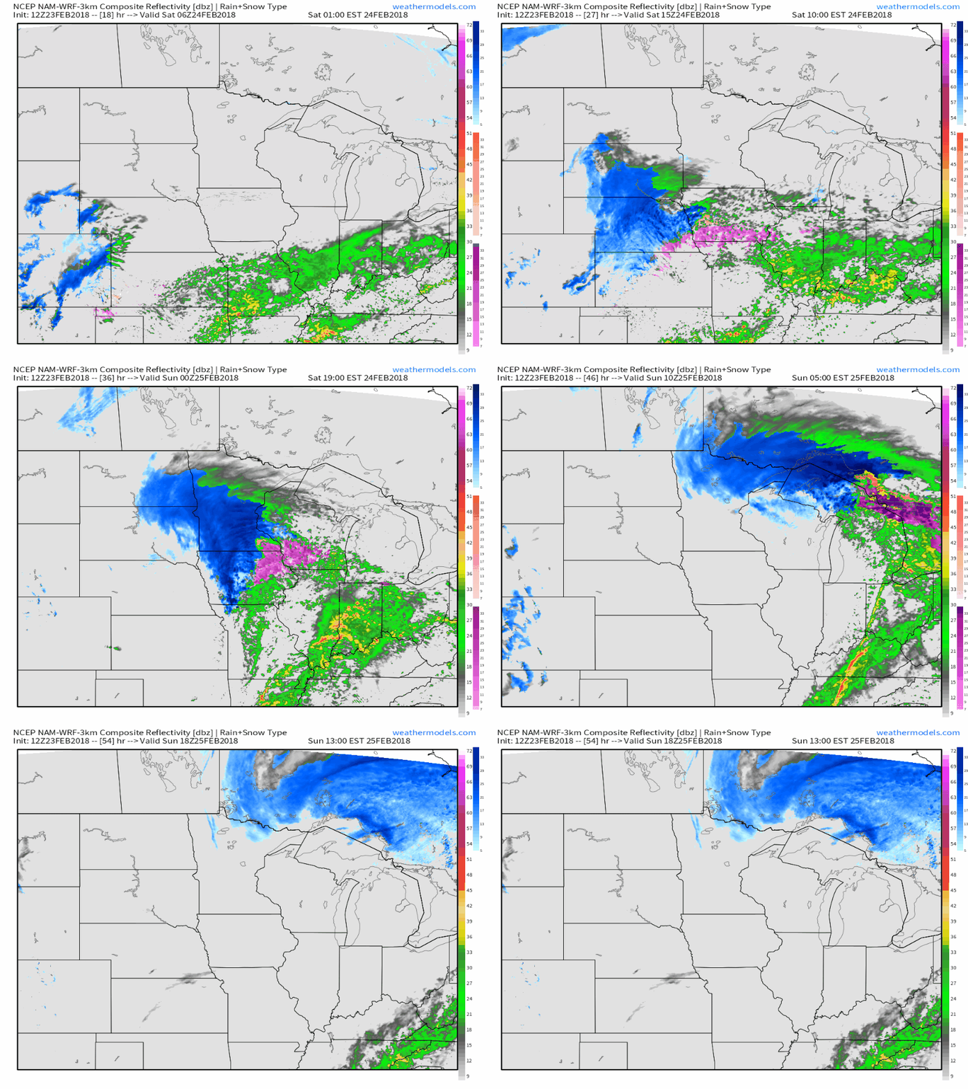
Here’s the NAM model’s interpretation of what the combination of those factors looks like from a simulated radar perspective. Notice the band of heavy snow that develops tomorrow morning over Nebraska before lifting quickly northeast into Minnesota tomorrow afternoon/evening. The snow will be heavy, but it won’t last very long in any given area, as the storm doesn’t really wrap up until it moves into Canada. The fast motion of the storm is what will keep totals limited. Also notice some ice southeast of the snow, extending from Kansas through NW MO and into SE IA. While significant ice accretion is not expected, it only takes a glaze of ice to make roads extremely slippery. Snow will wrap up quickly on Sunday morning as the storm races NE into Canada.
Maps from weathermodels.com.
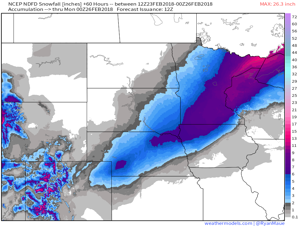
Here’s the NWS’s snow forecast for this storm. A general 4-8″ is expected from far NE Colorado through Central Nebraska and into NW Iowa/Southeast MN. The heaviest amounts will be found closest to the Canadian border, while lighter amounts are expected both farther NW where moisture will be limited, and farther SE where cold air will be limited. Overall, this won’t be a massive storm from an accumulation perspective, but it will cause slick travel conditions for a time tomorrow as it moves through.
Map from weathermodels.com.
For more information on how this storm will affect you and your area, check out all the tools we have both at weather.us and weathermodels.com, many of which I have linked to in this post.
I will have more updates as storms fire up tomorrow afternoon. Most of my storm coverage will be found on twitter, where you can follow @WeatherdotUS and @JackSillin for the latest info, along with the rest of our US team @RyanMaue and @Kachelmann.
-Jack
