Quick Hitting But Intense Storm To Bring Ice, Storms, And Snow To The East Tomorrow
Hello everyone!
The next storm to bring regionally significant impacts to the US is developing this evening in two parts over the Central part of the country. By tomorrow, those two parts will join forces over the East, resulting in a quick but intense burst of snow, ice, and rain including some potentially strong thunderstorms. I’ll take a quick look at each of these impacts, what’s causing them, and where you can find more information on weather.us and weathermodels.com to help you stay ahead of the storm.
Overview
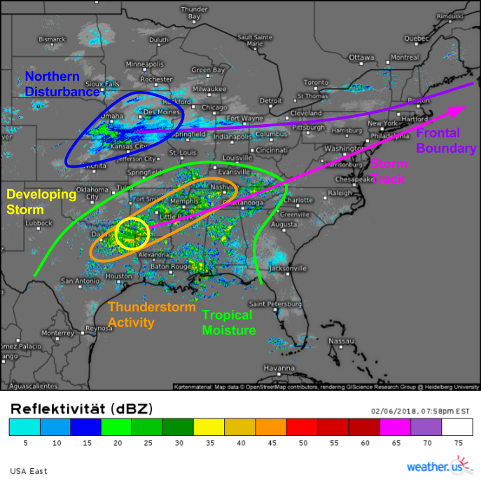
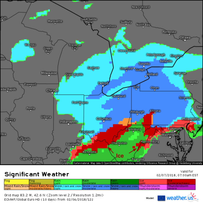
Here’s a look at the Eastern US radar composite this evening (click to zoom in to HD data) which shows all the elements of our storm system coming together. A plume of tropical moisture is noted with areas of heavy shower and thunderstorm activity from parts of Texas east through the Deep South. This moisture will be surging north and crashing into a cold airmass moving south from Canada. Just north of this clash, heavy snow is expected to accumulate up to a foot in parts of the interior Northeast. Right along the battleground between warm and cold air, an icy mix of snow, sleet, freezing rain, and rain is forecast with very slick travel in parts of the Ohio Valley and Southern New England. South of the colder air, where warmth and moisture will be more widespread, strong to potentially severe thunderstorm activity is expected with large hail being the main threat, along with the chance for a few low end wind gusts in the Deep South.
Snow
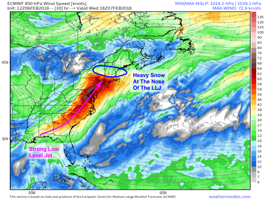
The most impactful part of this system will be the heavy snow it brings to the Northeast tomorrow. ECMWF forecasts shown above indicate a strong low level jet (LLJ) developing tomorrow afternoon along the East Coast, stretching from the Panhandle of Florida to Southern New England. Note the dramatic slowing of 850mb (~5,000ft) winds from SE NY/Southern New England (60-70kt winds) to Central/Northern New England (20-30kt winds). This indicates the “nose” of the LLJ, where it hits the dense cold airmass and points upwards as it is forced by that cold airmass to rise. The sudden rising of a conveyor belt of moisture imported directly from the Gulf of Mexico into a deep cold airmass is the perfect recipe for heavy snow, and that’s exactly what we’re expecting in the area highlighted above.
Map from weathermodels.com
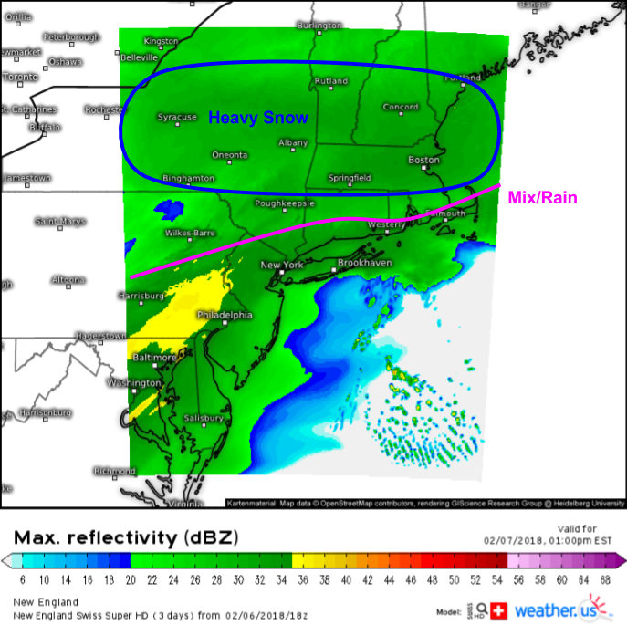
This simulated radar image from the Swiss Super HD model shows bands of heavy snow in Central/Northern New England tomorrow at 1 PM, the same time as the LLJ map shown above. Farther south, warm air will creep into parts of Southern New England as the strong SW winds of the LLJ itself will be capable of dislodging the cold airmass in place ahead of the storm. Click here for many more Swiss Super HD model products, and don’t forget you can click the map to zoom into state or even county level. You can also use the menus to the left of the image to select domains and explore different parameters.
Here’s a look at how much snow to expect through Thursday morning when the storm will have moved out. The jackpot will be in the mountains of ME/NH/VT where over a foot of snow is expected. Mixing will cut down on amounts in Southern New England, though it’s important to note that a snow/sleet/ice mix won’t accumulate to as much net frozen stuff on the ground, but is often much more slippery and results in higher impact to travel.
Icy Mix
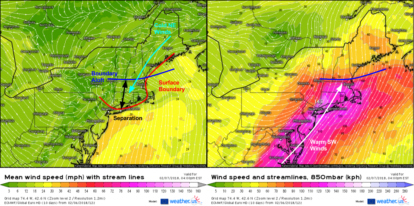
Here’s a comparison of the ECMWF’s surface wind forecast tomorrow afternoon with the same model’s 5,000ft wind forecast valid at the same time. Note that the leading edge of the warmest (above freezing) air leads the leading edge of the surface level warmth by almost 100 miles. This separation will allow warmth to surge in aloft while cold air hangs tough at the surface. This combination is what results in sleet and freezing rain, both of which are expected in Southern New England tomorrow afternoon.
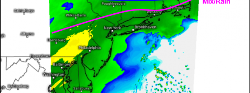
This NAM simulated radar image highlights the transition to ice/sleet across Southern New England tomorrow afternoon. Ignore the precipitation incorrectly tagged as rain (green) instead of sleet (salmon) over CT/SNY/RI, precipitation in those areas is likely to fall as sleet. Ice accretion amounts will remain below the thresholds needed for power outage concerns, but very slick travel is still an issue even with tiny amounts of ice.
Map from weathermodels.com
Earlier in the day, the same issues will be playing out over the Mid Atlantic and Ohio Valley. While snow falls from NE Ohio through W NY and NW PA, parts of S OH, NE KY, E WV, an MD will see sleet and freezing rain right in time for the morning commute. Impacts will be similar to those in New England- there won’t be enough ice for power outages, but there will be more than enough for very dangerous travel.
Storms
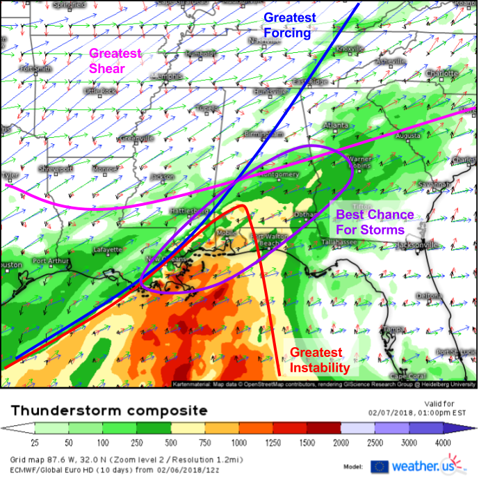
Here’s a look at the ECMWF’s thunderstorm composite product (what’s that?) for the Southeast tomorrow afternoon. Remember that there are three ingredients that are key to severe thunderstorm development: instability, forcing, and shear. You can see each on this map, and notice how no more than two overlap in any given area. Where there’s forcing and shear (N AL/TN), there’s no energy to fuel storms. Where you do have that energy, you’re too far south from the upper level jet to get the best shear. As a result, the overall severe threat will be limited, however some of the stronger cells will be capapble of marginally severe hail along with heavy rain and lightning.
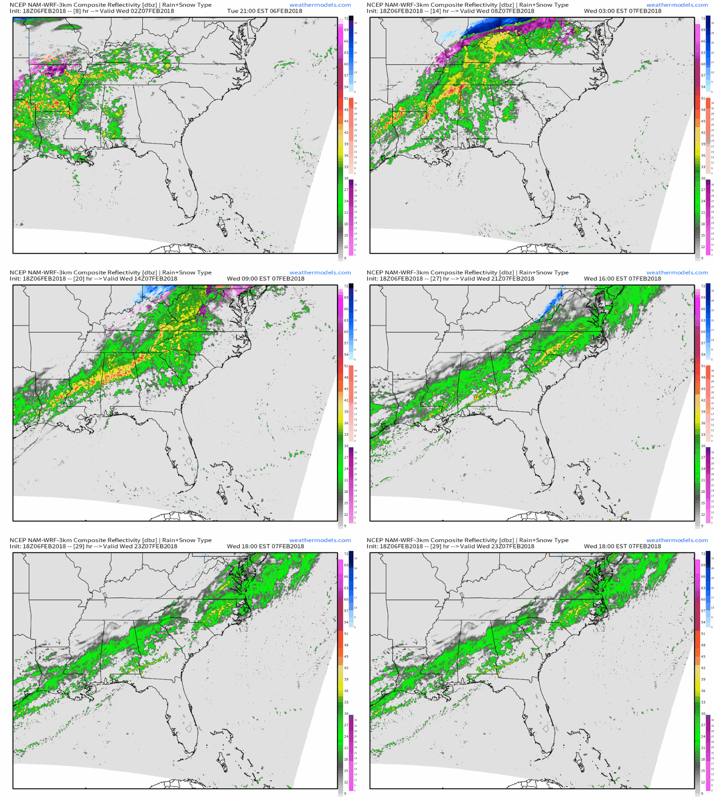
Here’s a simulated radar animation from weathermodels.com showing those storms evolving tonight and into tomorrow morning across parts of the Deep South. Be sure to follow the storms in real time with our HD radar and satellite products at weather.us (click to zoom in)!
The whole system will quickly zoom offshore Wednesday night, which will leave quiet weather for Thursday in advance of the next system which begins taking shape over the Plains on Friday.
-Jack
