Arctic Front To Spread Snow From North Dakota To South Texas Today Through Tuesday
Hello everyone!
After our large Ohio Valley/Northeast winter storm wrapped up yesterday morning, we’ve had a 24 hour stretch of generally quiet weather across the US. That’s coming to an end this morning, as attention turns to a strong Arctic cold front dropping south through the Northern Plains. This front will move all the way to the Gulf Coast by Tuesday morning, bringing yet another threat for wintry precipitation to the Deep South.
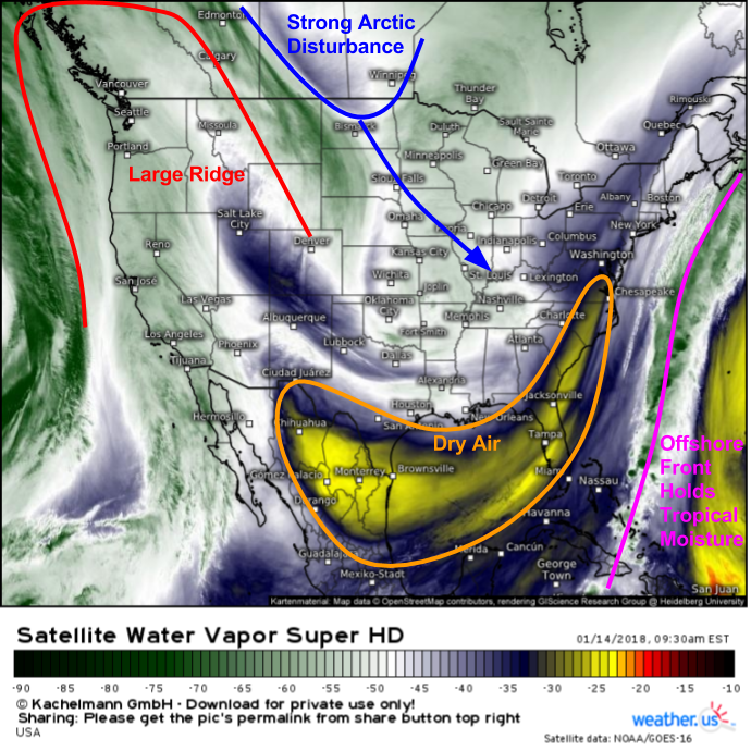
Water vapor satellite imagery (what’s that?) shows several features that will be important to the evolution of this front and its impacts. First and foremost is the disturbance itself, currently diving southeast through the Northern Plains. This will provide the energy needed to produce snow as the front travels southeast today. However, despite the strong nature of the available energy, snow totals are expected to be fairly light. This is due to the lack of moisture available to the system. There are three primary sources of moisture for an Arctic disturbance in the Northern Plains: the Pacific Ocean, the Gulf of Mexico, or the Atlantic Ocean. Each of those sources is blocked off today, which will prevent this system from bringing heavy snow and major accumulations. A large ridge stands between the disturbance and the Pacific Ocean, very dry air has moved in behind a front over the Gulf of Mexico, so even air tapped from that region won’t be rich in moisture, and a strong front is holding the Atlantic’s tropical moisture several hundred miles off the East Coast.
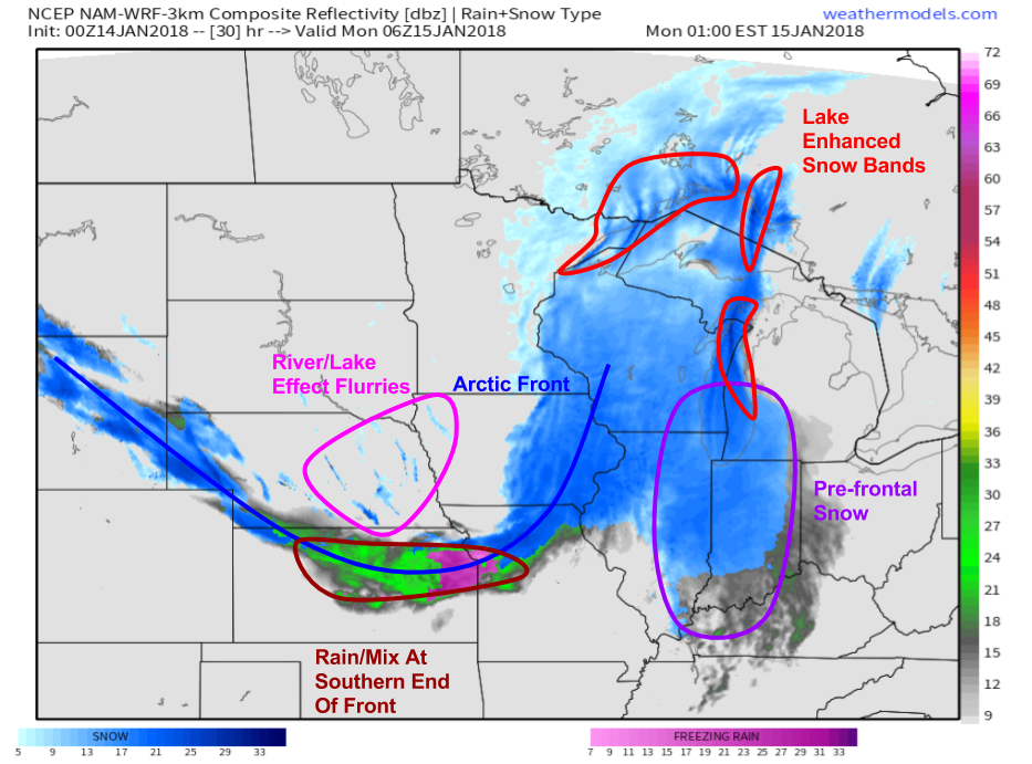
The result of the lack of moisture will be a lack of heavy snow. This map from the NAM model shows light to moderate snow along the front this afternoon, and as the front is pushed quickly southeast ahead of the swiftly moving energy, accumulations should be light.
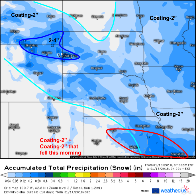
Here’s how much snow I’m expecting in the Plains through tomorrow afternoon, using the ECMWF’s QPF snow forecast (what’s that?). Coating-2″ amounts will be most common, with some parts of KS and MO seeing those amounts fall on top of some light snow that already fell this morning. Some parts of WY, MT, and SD will see some localized Pacific moisture enhancement, as well as a boost from terrain features, resulting in slightly higher totals.
Here’s a simulated radar image for tonight as the system begins to move into the Midwest. The front will continue to move south through the Plains, bringing the accumulations I discussed above. However, an area of low pressure will develop on the eastern edge of the front, over Wisconsin. As a result of this low, and of a little bit of moisture left from a system that moved through the Southern Plains this morning, snow will begin to break out ahead of the front itself across parts of Indiana and Illinois. Additionally, the cold air swirling around the Great Lakes will result in lake enhanced bands of snow, which, given their access to abundant moisture, will be heavy at times.
Map from weathermodels.com.
Here’s an accumulation map for the Midwest showing the effects of the enhancement due to the low pressure formation, the pre frontal snows, and the lake effect. All in all, it will still be a fairly minor event, but even a couple inches will be enough to make the roads slick, and visibilities will drop significantly in any of those lake effect bands.
As we move towards tomorrow night, our storm system will split into two parts. The first part will be the low that formed over Wisconsin and moved east through Michigan. This system will weaken as it traverses the Appalachian mountains, and will eventually go on to form a storm that brings snow to parts of Canada. Minimal accumulations are expected east of the Appalachians due to this system. The second part of the storm will continue to drive the cold front south through the Plains. As it reaches the Gulf Coast on Tuesday morning, the cold air will encounter some Gulf of Mexico moisture which, while not rich enough for heavy precipitation, will be enough for a wider swath of light-moderate precipitation to develop.
Map from weathermodels.com.
The ECMWF’s synoptic composite map (what’s that?) shows each of the ingredients behind the southern snow on Tuesday morning. By looking at the white isobars (lines of equal surface pressure), we can see a surface cold front draped along the Gulf Coast from Brownsville to New Orleans. Arctic high pressure can be seen crawling south into Texas as cold air pours south east of the Rockies. Meanwhile aloft, an area of mid level moisture is seen from Central Texas through Northern LA, NW MS, and SE AR. A jet streak centered over Memphis will result in rising air from Austin NE to Shreveport, even though the forcing associated with the surface front is displaced hundreds of miles southeast.
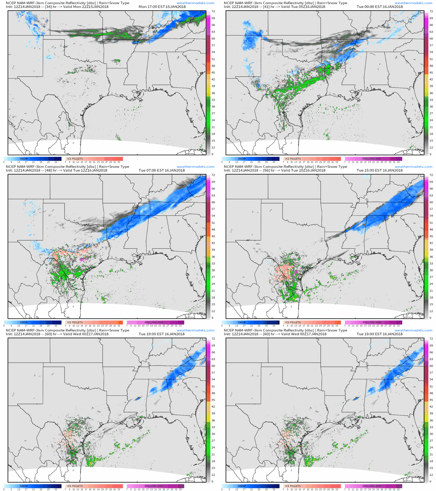
The results of these dynamics can be seen in this simulated radar animation showing a band of light-moderate snow developing late Monday night and continuing through Tuesday morning. Cold air will be a bit shallower in parts of south-central Texas, and as a result an icy mix of snow, sleet, and freezing rain is possible. Mixed precipitation will cause issues all the way to the Mexican border SW of San Antonio. Amounts of snow, sleet, and ice will be far from impressive, however it only takes a quick coating to make roads, bridges, and sidewalks extremely slippery! Snow and mixed precip will depart Texas on Tuesday afternoon, but will continue across parts of Georgia into Wednesday as that upper level energy moves east.
Map from weathermodels.com.
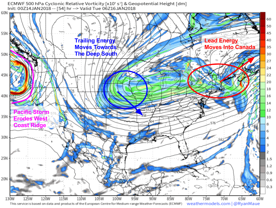
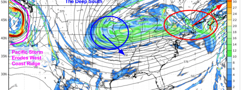
After bringing snow to the south, that second part of the disturbance will continue to march east, eventually finding the East Coast by Wednesday. Any time strong upper level energy hits the East Coast in the cold season, it’s important to watch for potential storm development. However, there’s one important feature that will prevent any major snowstorm along the East Coast this week. That feature is located several thousand miles away, in the Gulf of Alaska. A strong storm developing in the GOA will knock the West Coast ridge on its side, and will eventually lead to its collapse. Developments like this in the atmosphere are mirrored downstream, so it’s to be expected that the East Coast trough will become “positively tilted” or oriented in the same NE-SW plane as the West Coast ridge. This trough orientation favors SW winds aloft, which will push our developing storm well offshore. A weak disturbance well removed from this system will bring light-moderate snow to parts of New England, however due to the large scale pattern, a major storm is not expected.
I’ll have more updates on that New England snow event in the next couple days.
You can follow each one of the features I’ve discussed here, from the Northern Plains to the Great Lakes to the Deep South, using our wide variety of tools at weather.us including HD radar, satellite imagery, and current observations. Click any of our maps to zoom in to state and even county level, or use our custom zoom function to pick your own domains.
-Jack
