Winter Storm To Bring Widespread Snow And Ice From Mississippi To Maine Late This Week Into This Weekend
Hello everyone!
In last night’s update, I discussed two winter storms forecast to bring snow and ice to parts of the US this week and into this weekend. The first system was covered in more detail, because the forecast was more certain. Read the first part of last night’s update for info on that storm, and watch it evolve on our Satellite and Radar products at weather.us. This update will focus on the second storm, which wasn’t discussed with as much detail last night due to the higher uncertainty. While the forecast isn’t a sure thing even now, model guidance has come into clearer agreement in the last 24 hours regarding what to expect with this system, so I’ll dig a little deeper into it here.
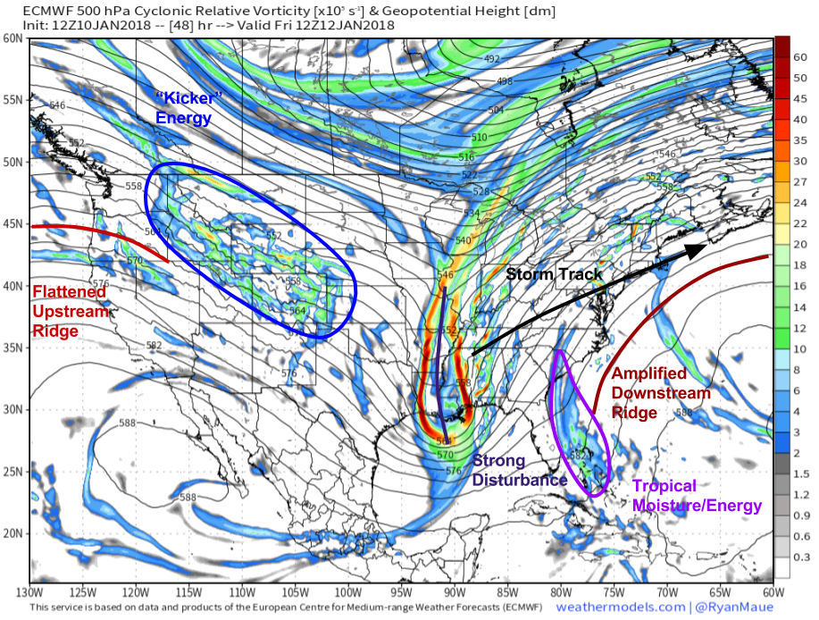
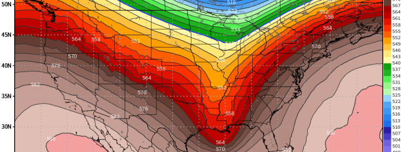
Here’s the ECMWF’s mid level energy map for Friday morning showing all the key players for our storm. The system itself will be located over the Lower Mississippi Valley, and the disturbance noted in that region will drive the development of the storm over Northern AL/MS. To the east of the storm, tropical energy will be lifting north between the storm and a highly amplified ridge of high pressure to the storm’s east over Bermuda. This energy will carry with it a lot of tropical moisture, helping the storm produce lots of precipitation despite being fairly weak overall. Meanwhile to the storm’s west, a large amount of energy will be diving SE through the Rockies while a flattened area of high pressure is located along the West Coast.
Map from weathermodels.com.
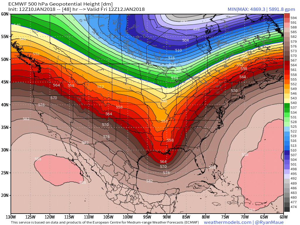
The two ridges of high pressure can tell us a lot about the behavior of our storm. The amplified downstream ridge will keep the storm from going too far east, and taking a track offshore. This will not be a coastal storm with snow for the I-95. That being said, the flattened upstream ridge will deny the storm too much amplitude, thus preventing a track farther to the west. If the ECMWF’s idea from yesterday ended up panning out, the mid level energy would be able to dig enough to form a cutoff low, which would pull the whole system back to the northwest by about 150 miles. This does not appear to be the case, which means we can hone in on a track from N MS/AL through the Central Appalachians (WV) and towards the Southern New England coast.
Map from weathermodels.com.
So what does that track mean for impacts? I’ll go through a general impacts overview now, and will be back tomorrow evening with a much more detailed look at the expected impacts as well as some of the science behind the forecast.
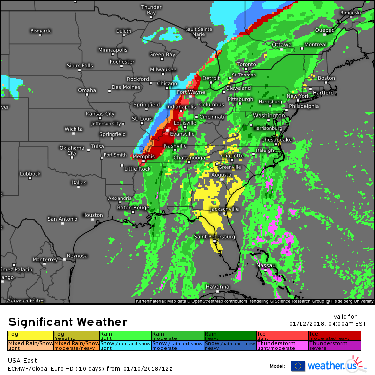
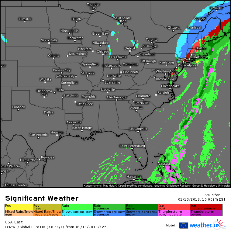
Here’s the ECMWF significant weather forecast for Friday morning. Notice the area of heavy rain over parts of Virginia, Pennsylvania, and New York. This is associated with that tropical disturbance I mentioned above. Watch for some localized street/small stream flooding due to this area of rain, especially as it heads into New England where storm drains are likely to be clogged with snow. Farther west, freezing rain will be in progress from Arkansas to Indiana as cold air will be quicker to rush in at the surface than aloft. Ice accretion will likely end up being the main story associated with this storm, as significant ice accumulations of a quarter inch or more are possible from the Memphis area all the way up through the Ohio Valley and Northeast to New England. The farthest NW fringe of the precipitation shield will change to snow, with bursts of moderate to heavy snow possible on the back side of the developing storm.
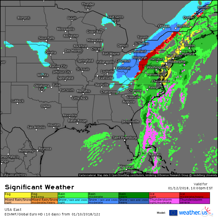
By Friday night, the storm will be moving across the Appalachians. Rain and freezing rain will change to snow across the Ohio Valley as the storm moves out. Bursts of moderate to heavy snow are once again expected before the storm drags the moisture away from this area. Rain and fog will impact the I-95 corridor from Virginia up through New England as warm moist air rushes north over a deep snowpack. Meanwhile, freezing rain will continue near the border between rain and snow, with potentially significant ice accumulations in parts of Central PA and NY.
By Saturday morning, precipitation will be ending for everyone but New England as the storm moves ENE near Long Island. Far interior parts of New York and New England will see a complete changeover to snow, with most of the rest of the area away from RI and SE MA see freezing rain and/or sleet. The system will move out Saturday afternoon, though light to moderate snow could linger into Sunday for Eastern New England due to a sneaky little setup I’ll discuss more as we get closer (I’ve already mentioned it a couple times on Twitter if you follow @WeatherdotUS and @JackSillin).
I’ll have a more detailed look at each impact (rain, snow, and ice) as well as some of the finer points of the science behind the forecast tomorrow afternoon/evening.
-Jack
