Pair Of Storms To Bring Rounds Of Wintry Precipitation From The Rockies To The Appalachians This Week
Hello everyone!
While recent winter storms have brought snow and ice to parts of the East Coast, this week that pattern will be shifting. We’ve already seen the bone chilling cold retreat from the East Coast at the beginning of this week, now the end of the week will feature changes in the pattern of wintry precipitation. Instead of snow and ice being focused on the East Coast, we’ll turn our attention to the middle of the country, where snow is expected to fall from Montana east to Maine, and from Minnesota south to Mississippi.
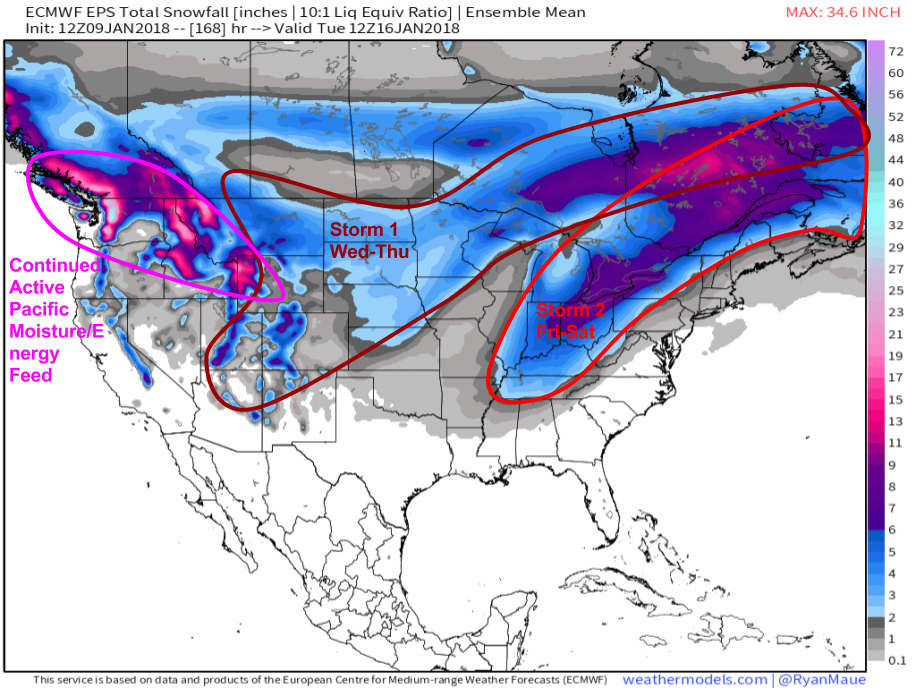
Here’s the ECMWF Ensemble Prediction System (EPS)’s forecast for how much snow is expected in the next 7 days. I wouldn’t focus all that much on amounts, but I like how this map shows who’s expecting snow from each of the two storms we’re watching through this weekend. The first storm will be the farther west of the two. It will bring snow from the mountains of Arizona and New Mexico through the Northern Plains into the Lake Superior area. Snow from this system will generally be light to moderate, with most amounts staying under 6″ not including terrain enhanced totals in the Four Corners region. The second storm will form a little later in the week, and will track farther east than the first one. The Ohio Valley will be the epicenter for this storm, with some areas likely to receive over 6″ by the time things wrap up early in the weekend. Impacts won’t be limited to the Ohio Valley, however, snow and ice will cause problems in parts of the Mississippi Valley, as well as in parts of the interior Northeast.
Map from weathermodels.com.
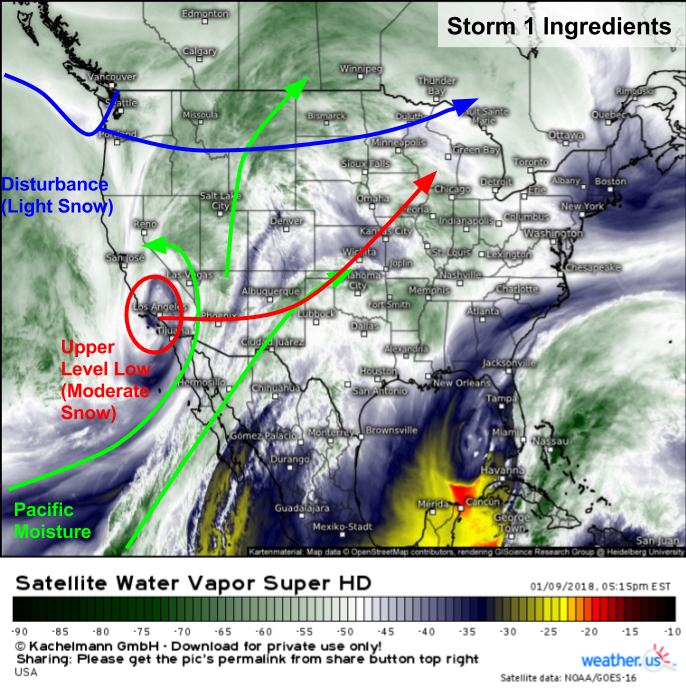
Water Vapor satellite imagery (what’s that?) highlights all the components of storm number one. A strong upper level low moved onshore today in Southern California, bringing tremendous flash flooding and mudslides to parts of the LA region. I discussed this storm yesterday, and unfortunately the concerns I outlined there did indeed pan out. This system will move east tonight, emerging out onto the Plains tomorrow. Due to the strength of this system, as well as its Pacific moisture feed, moderate snow bands can be expected from Colorado to Minnesota tomorrow and Thursday, with some of the stronger bands producing locally heavy snow. However, the upper level low will be getting sheared apart as it moves NE Energy now moving onshore in Washington State will move east tonight as well, emerging out onto the Plains at a similar time as our upper level low, just a bit farther north. This system will be weaker, so expect only light/moderate snow to be associated with it.
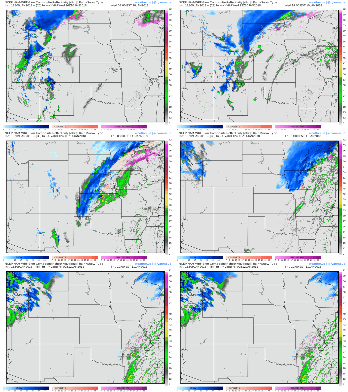
Here’s an animation of simulated radar from the NAM model showing snow impacting parts of the Plains tomorrow and Thursday as the two elements of the first storm move through. Notice the lighter snow forecast in the Dakotas with locally heavier bands in parts of Colorado, Kansas, and Nebraska. To the northeast, across parts of Iowa, Wisconsin, and SE Minnesota, warm air may hold on longer aloft than at the surface, resulting in a brief period of sleet and/or ice. While ice accretion amounts will generally be light, it doesn’t take anything more than a quick glaze to result in extremely slippery roads.
Maps from weathermodels.com.
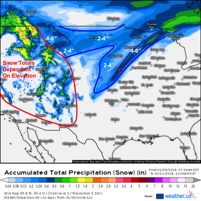
Here’s a look at how much snow to expect from the first system, through Thursday evening. Totals in the Rockies will depend highly on elevation, so I haven’t drawn in each contour there. However, some of the peaks in Montana could see over 2 feet by Thursday evening, with more on the way through the weekend. The heaviest non-elevation snow will be found from parts of Eastern Nebraska through SE Minnesota, where 4-6″ is expected in a narrow band of moderate-heavy snow right on the NW side of the remnant ULL. For more info on this type of map and how to use it, check out this video.
Snow will move out Thursday evening, with a lull developing Thursday night before our next storm on Friday.
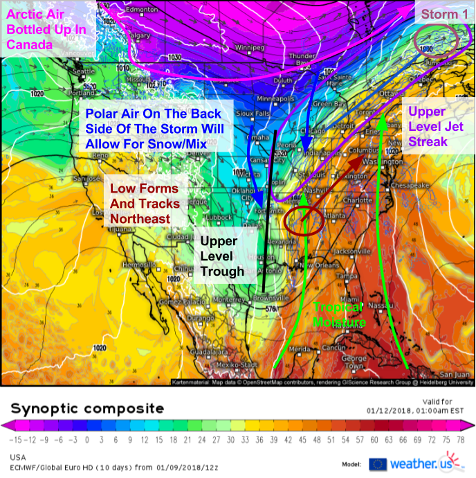
Here’s a look at the ingredients for storm number two beginning to line up Thursday night as shown by the ECMWF’s synoptic composite product (what’s that). A deep upper level trough will be moving east through Texas, and will begin to close off into an upper level low by Friday morning as it moves into Louisiana and Mississippi. Tropical moisture will be streaming north ahead of this system, as a strong ridge builds downstream over Bermuda. This ridge will act as a wall, stopping the storm from moving east and developing offshore. Instead, the storm will turn north much sooner than we’ve seen in the past month. As a result, most of the I-95 corridor south of Boston can expect a plain rain event from this system. The heavy snow focus will shift west into the Ohio Valley, where over 6″ of snow is possible. The bitter cold Arctic air that has helped to fuel explosive storm development off the East Coast recently is bottled up in Canada, meaning this storm won’t set any records in terms of its strength, but the clash of deep tropical moisture with polar air just cold enough for snow will bring an impactful snow/mix event regardless of the relative weakness of the storm system itself.
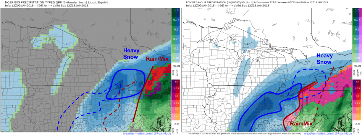
While the forecast for storm 1 is fairly confident, give or take a few miles, the forecast for storm 2 remains much more up in the air. I’ve taken the GFS and ECMWF precipitation type/amount forecasts for Saturday morning and placed them side by side above, marking where each model is forecasting heavy snow, and the rain or mix/snow line. Notice how the two models are over 100 miles apart with each feature. For parts of Indiana, the ECMWF forecasts near blizzard conditions, while the GFS indicates nothing but flurries. This discrepancy highlights the uncertainty in the forecast, something we have plenty of tools at weather.us to make sense of.
Maps from weathermodels.com.
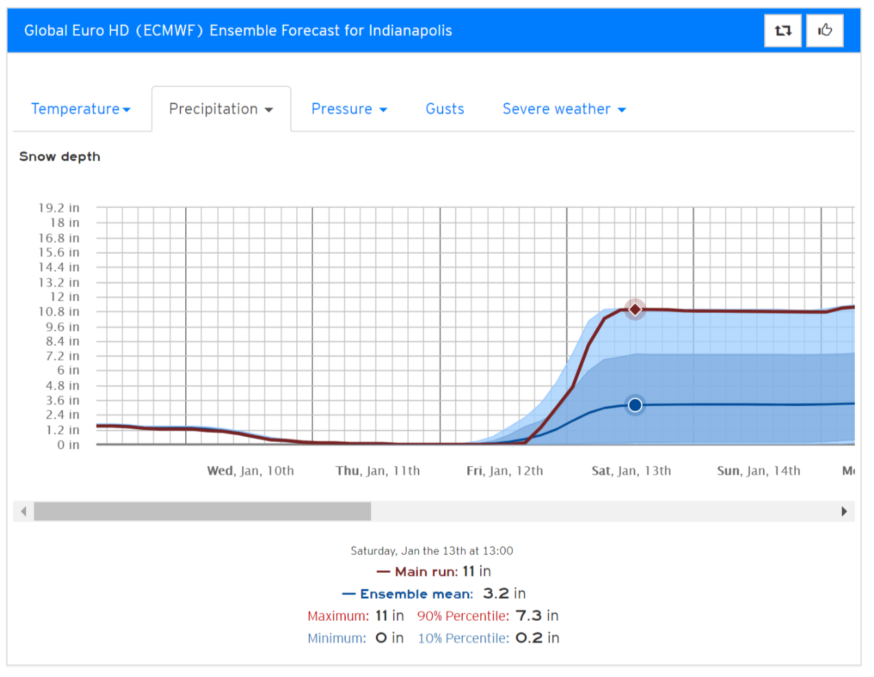
Here’s our Forecast Ensemble product for the snow depth in Indianapolis, Indiana through the end of the storm. Notice the very wide spread among ensemble members, from 0-11″. The deterministic model we compared to the GFS above is at the very top of the ensemble guidance envelope. Not a single one of the 51 ensemble members forecasts more than the operational model. This is a sign that perhaps that solution is a high outlier, and that actual amounts may be much lower. A range of reasonable best and worst case scenarios is given by the 10th and 90th percentiles respectively. There’s roughly a 90% chance of getting more than .2″ (a coating) in Indy, while there’s only about a 10% chance of getting more than 7.3″ (a solid storm). The ensemble mean, while far from perfect, can give a good ballpark estimate at this range: ~3″. You can get this data for any town in the world at weather.us, just select our Forecast Ensemble product and type in the location you’re looking for.
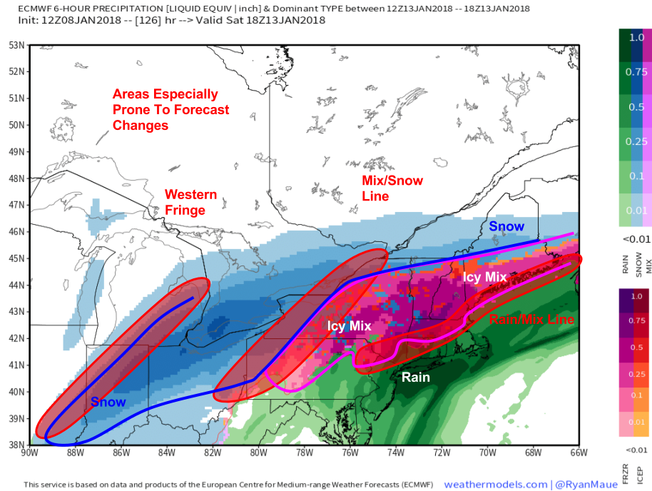
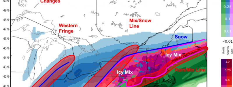
As the storm moves ENE, it will run into a low level cold airmass brought south by the first storm. The result will be an expansive area of icy mixed precipitation from New England through New York and into parts of Pennsylvania. I’ve picked an old ECMWF run to highlight this, because I believe recent runs are too warm and underestimate the power of low level cold air in these areas. It should be noted that there are several areas of especially high uncertainty with this forecast, where very small changes in the storm’s track will make huge differences to the sensible weather forecast. These include the western fringe (who sees moderate snow and who sees nothing), the mix/snow line (who sees 6″ of snow and who sees 1″ of sleet), and the mix/rain line (who sees significant icing, and who sees a cold rain). While everyone in the path of the storm should keep up to date with the latest information, staying informed and being ready for multiple potential outcomes is especially important in these areas.
Map from weathermodels.com.
The storm will depart into Canada on Sunday leaving cool and dry weather in its wake.
Much more on this system as it gets closer!
-Jack
