Snow Changes To Ice In New England With Slippery Travel Today And Tomorrow
Hello everyone!
Our weather pattern will continue its active streak in the next few days as low pressure brings snow and ice to parts of New England. The forecast for this system is complex, and it offers a nice opportunity to observe a number of fascinating meteorological processes. Unfortunately, the net result of these dynamics will be slippery roads and slow travel across a wide area just as folks are travelling for the holidays. These issues will start promptly today, as a weak disturbance brings snow to parts of upstate New York and New England.
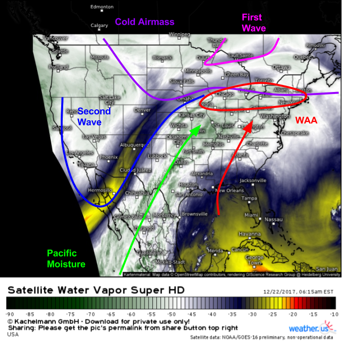
Super HD water vapor satellite imagery (what’s that?) shows all the major features that will play a role in the upcoming ice and snow for New England. High pressure that moved into place yesterday has locked in a cold airmass from the Northern Plains all the way to the New England coast. We can see two disturbances (waves) on this map that will be responsible for the two rounds of precipitation expected today and tomorrow. The first wave is the weaker of the two, and is currently located over the Great Lakes. The second wave is much stronger, and is currently moving out of the Desert Southwest. What impacts will each wave bring, and how will their different strengths impact the sensible weather in New England?
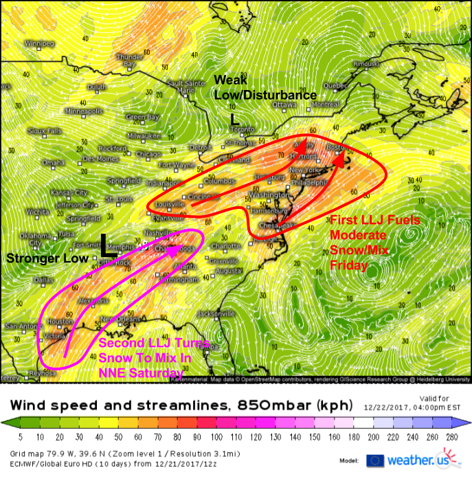
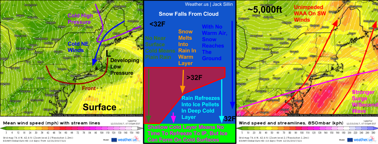
850mb wind forecasts from the ECMWF show both disturbances this afternoon. The first wave is the weaker of the two, and its Low Level Jet (LLJ) will be strong enough to fuel snow for much of New England, but won’t be strong enough to change precipitation over to sleet or ice, outside of parts of New York. The second wave is much stronger, and its developing LLJ will indeed be powerful enough to dislodge cold air aloft.
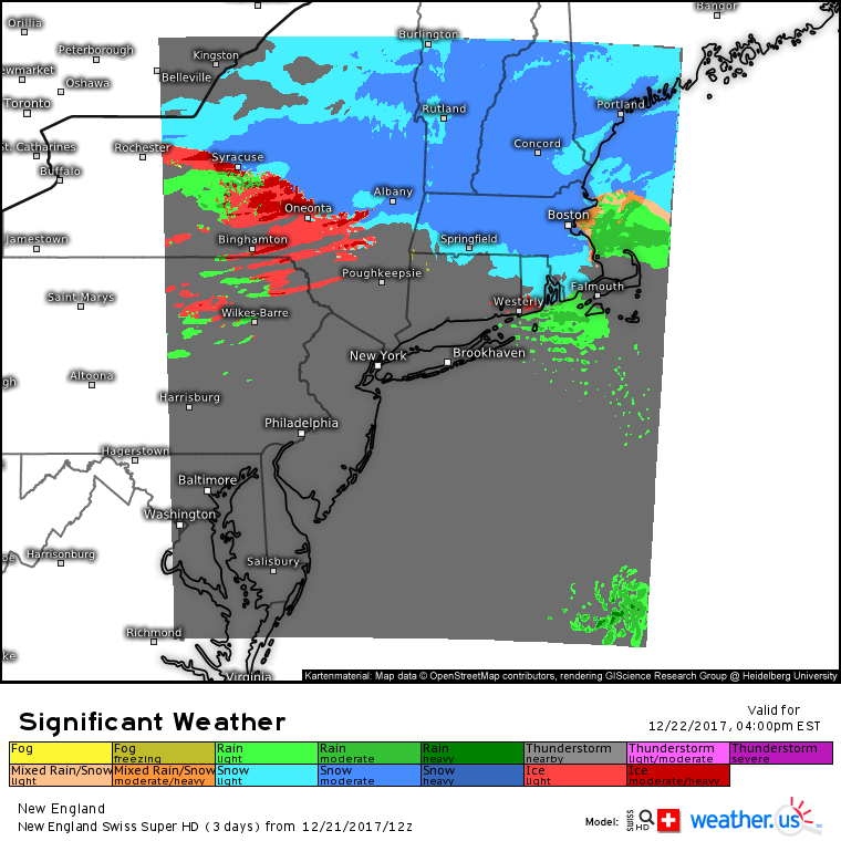
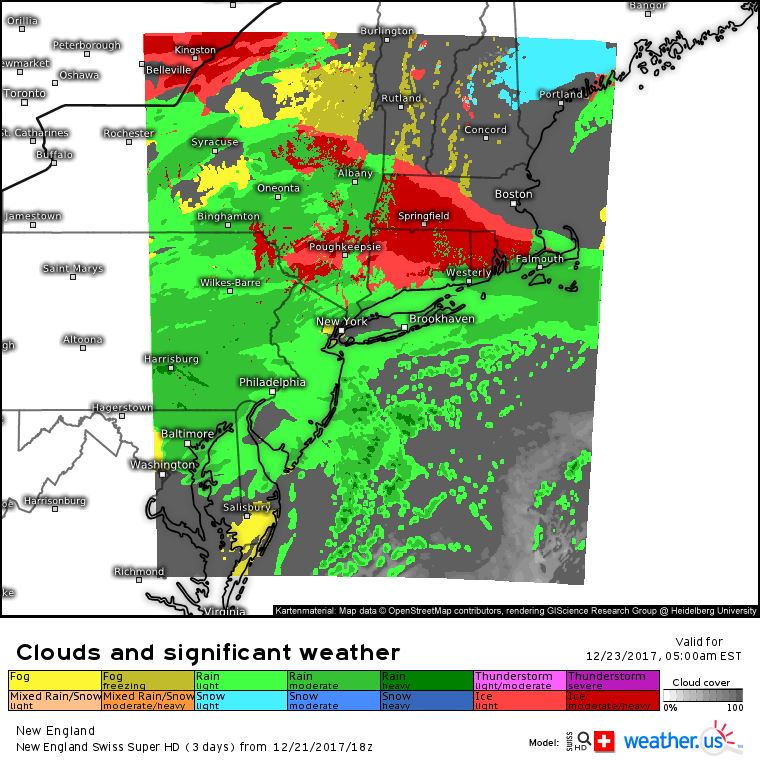
Here’s the Swiss Super HD model’s depiction of the first wave’s impacts this afternoon. Most of New England and upstate New York will see light to moderate snow, with the steadiest and heaviest precipitation falling north of the Mass Pike and south of Route 2 in ME/NH/VT. The vast majority of the region will see snow, but some of the beaches of Massachusetts may see snow mix with rain at times. To the west, warm air will begin to work in aloft across parts of New York, and a change to ice is likely south of the Thruway from Rochester.
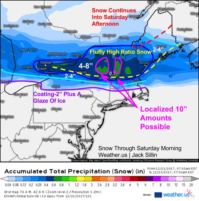
Here’s a look at what to expect from the first wave through Saturday morning. A very cold airmass combined with just enough mid level dynamics will result in fluffy “high ratio” snow for northern parts of New York and New England. Why “high ratio”? That refers to the snow to liquid ratio. The fluffier the snow, the more inches of accumulation are produced per given amount of liquid equivalent. Snow ratios will climb past 15:1 for much of the highlighted area, meaning that for every 1″ of QPF (a Quantitative Precipitation Forecast) that falls, 15″ of snow will accumulate. This video has much more information on snow to liquid ratios and forecasting accumulation from QPF and SLR’s.
As we approach tomorrow morning, wave number one will be departing through Maine, while wave number two will begin the second phase of the storm for areas across the Northeast. Most folks outside of New England will experience wave number two primarily as a rain event, however areas from Connecticut all the way up into Maine will see a prolonged period of freezing rain. This freezing rain will result in ice accretion on roads, trees, and any other exposed surface. So what causes freezing rain and why is it in the forecast?
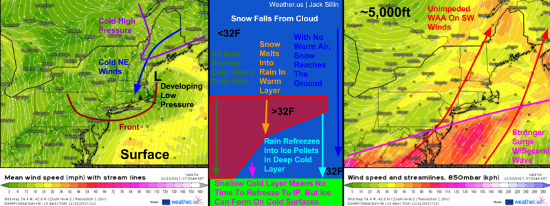
This graphic explains what causes freezing rain, and why it’s in the forecast for New England tonight and tomorrow. To get freezing rain, you need a deep layer of warm air aloft to melt snowflakes that fall from above. Then, you need a very shallow low level cold layer. This is the tricky part, if it’s too deep a layer, you’ll get sleet which, while annoying, won’t cause power outages or any of the other issues associated with ice accretion. However, if the cold air is too shallow, it can become fragile and scoured out by warm air trying to move north. You need just the right setup to get freezing rain, and it looks like that’s exactly what’s going to happen. At the surface, cold air is locked in. Cold high pressure is locked in to the northeast, and as a bonus, low pressure is developing in the Gulf of Maine. Counterclockwise flow around this low will help move even more cold air south. Meanwhile aloft, none of these features will exist. Instead, we’ll be in a broad region of SW winds that will transport (advect) warm air into the area.
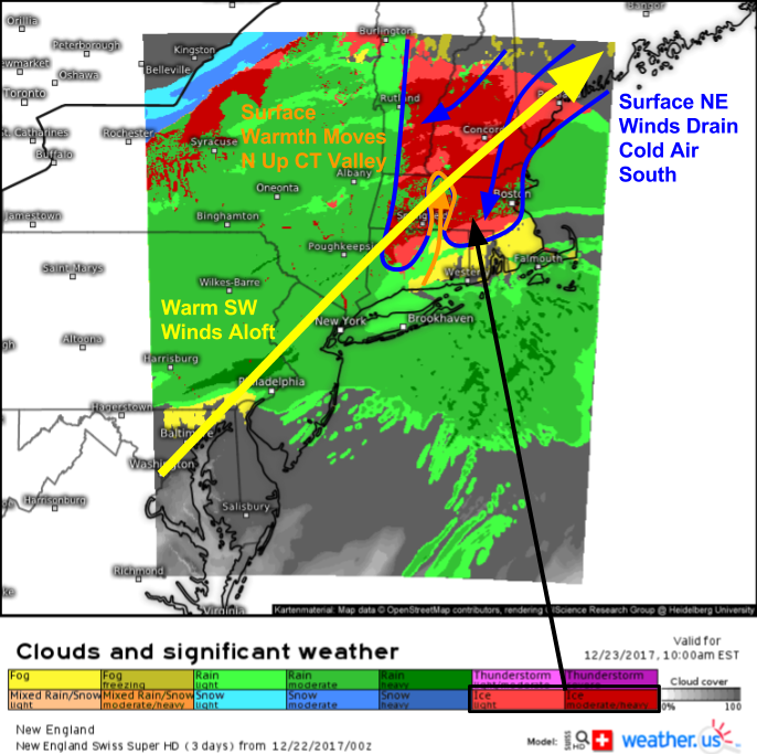
Here’s the net result on the sensible weather of all the dynamics discussed above. Swiss Super HD model forecasts show light to moderate ice (freezing rain) across much of interior New England by tomorrow morning. The Gulf of Maine low has “tucked” cold air into the Boston area, while high pressure to the north has dammed cold air against the high terrain of Vermont and Western Massachusetts. As warm air continues to stream in aloft, we have the perfect setup for freezing rain. As the day progresses tomorrow, look for surface cold air in the CT valley to begin to get scoured out as cold air damming influences are tempered there. Rain will impact much of New York as the coldest air retreats to the east, but some of the NW parts of the state will see a mix of snow and freezing rain as cold air hangs on longer.
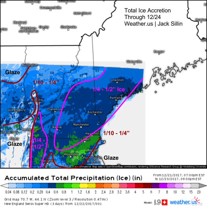
Here’s my forecast for how much ice will accrete (accumulate) with this storm. The hardest hit areas will be the higher terrain of Western MA and Southern VT as well as much of the Southern parts of Maine and New Hampshire. While more precipitation is forecast to fall as ice in parts of Eastern Massachusetts, temperatures will be warmer and precipitation rates higher in that area, both of which will limit how much ice can actually stick to power lines. As rain freezes on surfaces, it releases latent heat of fusion. This occurs because any substance in its liquid phase has more energy than the same substance in its solid phase. So when a liquid becomes a solid, energy is lost from that substance, and released into its surrounding environment. Because temperature is a measure of heat energy, this latent heat release, when it occurs on a large scale (i.e. when heavy freezing rain is falling and trillions of raindrops are freezing), can raise the temperature above freezing. This is another reason areas west of Boston won’t see as much ice accretion as parts of Maine and New Hampshire.
All in all, ice will be disruptive from this system but likely not destructive. A half inch of ice will be enough to take down some trees and power lines, but I’m not expecting anywhere near the same level of issues as some of the notorious ice storms in this area. In the highlighted areas expecting more than a quarter inch of ice, prepare for power outages. Even if you’re not in this area, watch for slick travel- you only need a glaze of ice to prevent your tires from getting much if any traction!
Precipitation will move out Saturday night, with colder air returning to all parts of the area on NW winds. That cold air will set up our next storm system, due to arrive on Monday. I’ll have a blog post detailing that system this afternoon!
-Jack


Thanks for the layered explanation. Is this a different kind of cold air damming caused by wind sheering, or called something else in weather land?
This was a pretty classic case of cold air damming caused by cold air being stuck on the east side of the Appalachian mountains. One of the results of the CAD is wind shear (winds increase in speed and change direction with height), but it’s not necessarily caused by that (though its impacts, such as freezing rain, are)