Heavy Rain And Severe Storms Move Into The Southeast Today While Snow Expands Into The Rockies
Hello everyone!
Today’s weather will be controlled by the same two systems we were watching yesterday: one in the Southeast, and one in the Rocky Mountains. Impacts from both systems will shift a bit today compared to yesterday, but the general themes will be quite similar.
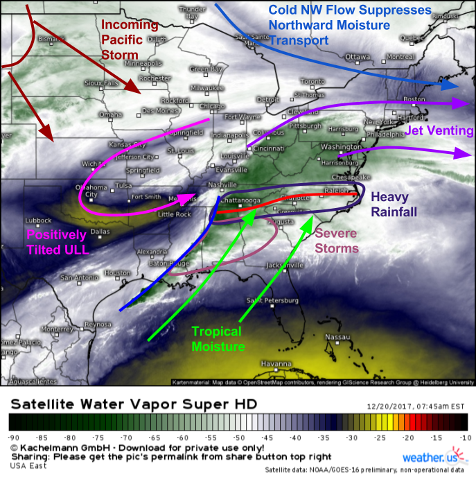
Water Vapor satellite imagery (what’s that?) gives a good summary of what to expect with the Southeastern system today. The storm won’t be as amplified today, meaning its impacts will be dampened a little bit. You can see on satellite loops how the storm is getting squished between the incoming Pacific storm and an outgoing system in New England. With nothing downstream over the Atlantic to inhibit eastward progress, look for the system to “shear out” and quickly escape off the Carolina coast. The shearing out process means that today’s dynamics, and thus storms, will be weaker compared to yesterday. We’ll still look for some severe storms along the cold front, they just won’t be as strong as yesterday’s. The same story will unfold with rainfall, where some flash flooding is possible today, the risk will be lower compared to yesterday.
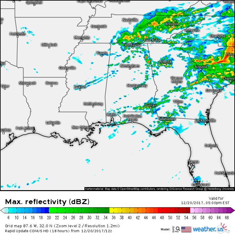
Here’s a look at the simulated radar for later this morning. Note the line of strong storms stretching from Central Alabama and Georgia down into the Gulf of Mexico. This is where some damaging wind gusts are possible. Farther north, steadier rains will continue along and north of the warm front draped from the Atlanta area over into Southern North Carolina. This is where some localized flooding issues are possible with 1-3″ of rain expected.
Activity will quickly simmer down this afternoon as the storm’s dynamics continue to weaken and shift east. Showers and potentially a few weak storms will linger as the upper level low passes overhead, but no severe weather is expected. Just use caution if a downpour pays a visit on your commute home. Dry conditions will return to the area tonight.
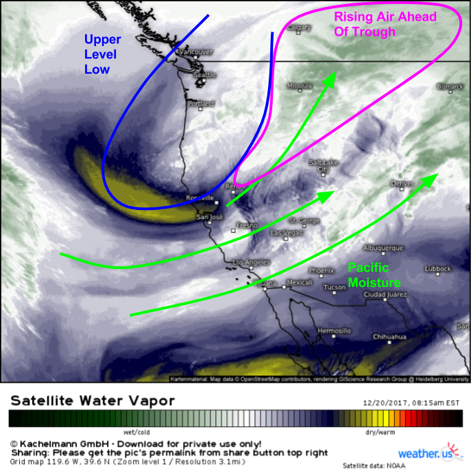
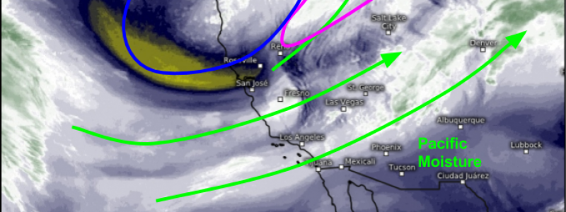
Water Vapor satellite imagery is also helpful for visualizing our Western system today. We can see a strong upper level low moving SE towards the OR/CA border. Ahead of the low, air is rising and Pacific moisture is streaming inland. This combination will result in snow, especially for parts of the Northern Rockies that will see the strongest dynamics from this system. As the system continues to move east, snow will spill over the Rockies and into the Northern Plains. Radar imagery and current observations indicate this process is already in progress across NE Montana and North Dakota.
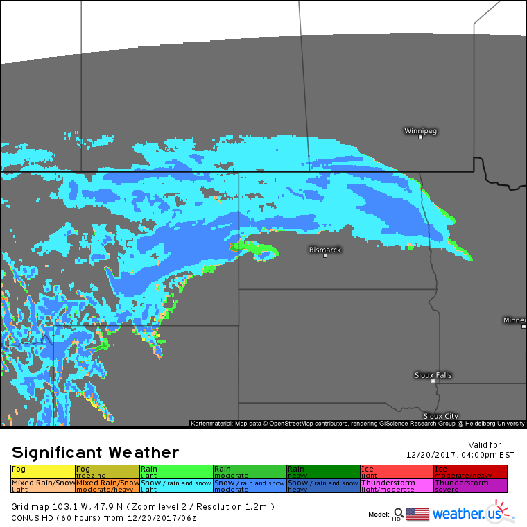
Model forecasts show snow continuing to spread east this afternoon, and several inches of accumulation are expected along with gusty ENE winds. Watch for dangerous travel in areas of snow and blowing snow with reduced visibilities and snow covered roads.
Snow will continue to move SE tomorrow as low pressure develops in the lee of the Rockies.
For more information about your local forecast: https://weather.us/
For more information about the local forecast for ME/NH: https://forecasterjack.com/2017/12/20/cooling-off-today-5/
-Jack
