Upper Level Low Brings The Threat For Severe Storms And Flooding Across Parts Of The South
Hello everyone!
An upper level low will be ejecting east into Texas tomorrow, and much like on Saturday, showers and storms will develop in response. This system will be a bit stronger than Saturday’s, and its impacts will adjust upward accordingly. Instead of moderate rain showers with scattered heavier thunderstorms, we’ll be looking at a more widespread area of heavy rain, with thunderstorms reaching severe levels in some places. So what’s behind the storms?
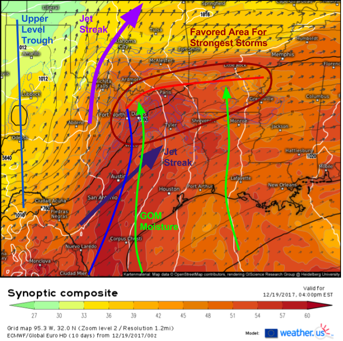
As is often the case, the ECMWF’s synoptic composite map (what’s that?) is a great way to peer under the hood of today’s system. The black lines reveal the upper level low I mentioned earlier. It’s located just SW of Lubbock, TX and is the centerpiece of a large upper level trough. Generally speaking, the front side of troughs favor rising motion. In order to get storms though, we’ll need a couple other ingredients. If we look at the shaded parameter (theta-e, a measure of heat/moisture), we’ll see a warm, moist airmass in place east of a cold front from Austin and San Antonio NE towards Louisiana. Southerly winds ahead of the front will continue to carry Gulf moisture northward today, which will help fuel the storms. The final important ingredient to get storms to form is a warm front, located from a developing surface low near Dallas east into the area just south of Little Rock. This front will provide focused lift for storms to develop. Some of these storms will be strong to occasionally severe!
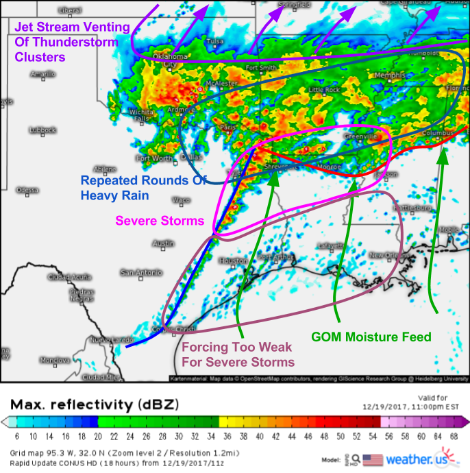
Here’s a look at the simulated radar for this evening across parts of the South. We can see each element of our storm lining up, and how each of the features described above plays a role in the practical part of the forecast. The warm front we saw above will be pushed south by rain cooled outflow from thunderstorms that develop along it. As a result, the severe weather threat for places like Memphis and Little Rock will be limited. However, we can also see the Gulf of Mexico (GOM) moisture feed in the simulated radar image, as light showers drift north in that southerly flow. As this moisture rich air hits the warm front/outflow boundary, it will be forced to rise, resulting in additional shower and thunderstorm development.
I think the best chance for severe storms will be along the cold front and along/south of the warm front this evening. That’s where you’ll get the best combination of forcing and instability. North of the warm front, there’s more than enough forcing (rising motion not due to thunderstorms) but very little instability. Head too far south towards the GOM, however, and you’ll get plenty of instability, but not enough rising motion to get strong storms to develop.
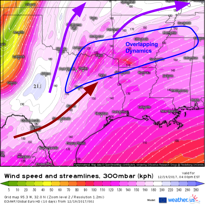
One of the features we were able to see on the Synoptic Composite above that I made note of on the graphic but didn’t discuss in detail is the jet stream pattern. We have two jet streaks in the area today, one very strong anticyclonically curved streak and one weaker cyclonically curved streak. These streaks will work together in a process known as “jet streak coupling”. This happens when the area of enhanced rising motion from one jet streak overlaps with the area of enhanced rising motion from another jet streak. The net effect is twice as much lifting for a given area. Today, this area will be NE Texas and Southern Arkansas.
On the simulated radar image, we can also see another benefit the jet streak will give to thunderstorms today: enhanced outflow. As thunderstorms lift air towards the top of the atmosphere, that air begins to pile up if there’s no outflow. It wouldn’t take long for that air to pile up enough to begin to sink again, shutting off the thunderstorm’s updraft. However, with a strong jet streak nearby to whisk air away from the top of the atmosphere, thunderstorms have to work even harder to lift more air up through the atmosphere to fill that void. This enhanced rising motion will only enhance the strength of the storms in that area.
Even though there won’t be the convective instability to support severe weather in these areas north of the warm front, the intense rising motion from the jet streak will help to fuel repeated rounds of heavy rain that will result in a flash flooding threat.
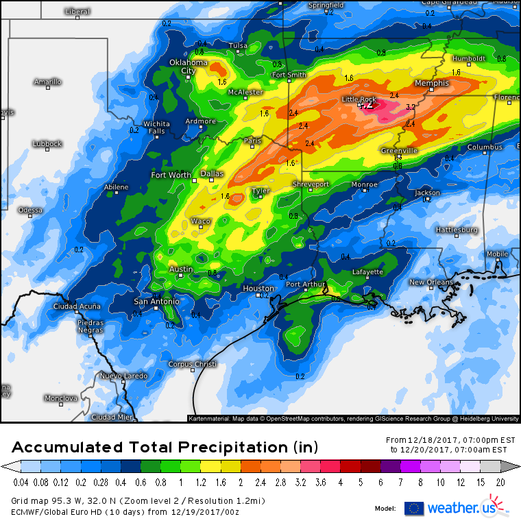
Here’s the ECMWF’s forecast for total rainfall through tomorrow morning. The highest amounts will be found in that zone I highlighted above that stretches from Dallas to Little Rock and Memphis, just north of the warm front. A general 1-3″ of rain is expected in this area, with locally higher amounts to 5″ possible where thunderstorm cores train repeatedly over the same area. Lighter amounts will be found to the northwest of this zone where moisture will be limited, and southeast of this zone where forcing will be limited.
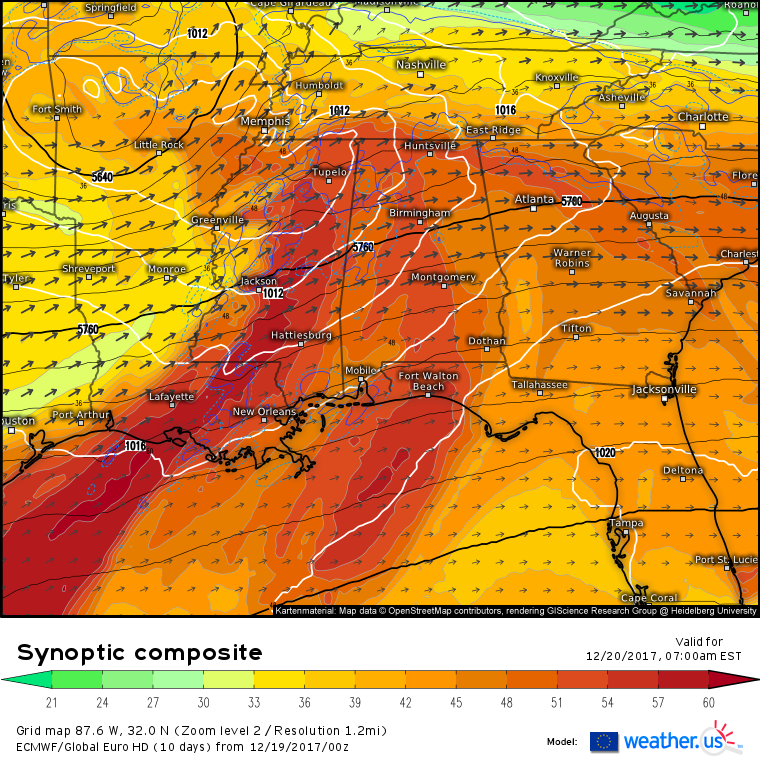
The whole system will shift east tomorrow, with many of the same dynamics playing out across parts of the Southeast. The synoptic composite map reveals many of the same features discussed above. Notice the upper level low NW of Little Rock, the plume of warm moist air flowing out of the GOM, the warm front extending from Mississippi through Alabama and into Georgia, and the jet streak coupling just to the north of the warm front across Tennessee. Expect a similar lineup of impacts tomorrow, with strong to severe storms along the warm front, and heavy rain/flash flooding just north of the warm front. I’ll have more details tomorrow morning!
-Jack
