Redeveloping Clipper To Bring More Snow To New England Tuesday
Hello everyone!
It’s been barely 12 hours since the last flakes from yesterday’s storm departed, but all eyes are now turning forward to the next chance for snow in the Northeast. A clipper system will be diving SE across the upper Midwest tomorrow, and it will reach the Atlantic Ocean by Tuesday morning. When the cold and energetic clipper finds the warm waters of the Atlantic, it will redevelop offshore, resulting in bands of snow for parts of the Northeast. Let’s dig a little deeper into some of the meteorology behind this forecast, because it’s both fascinating and important to anticipating impacts.
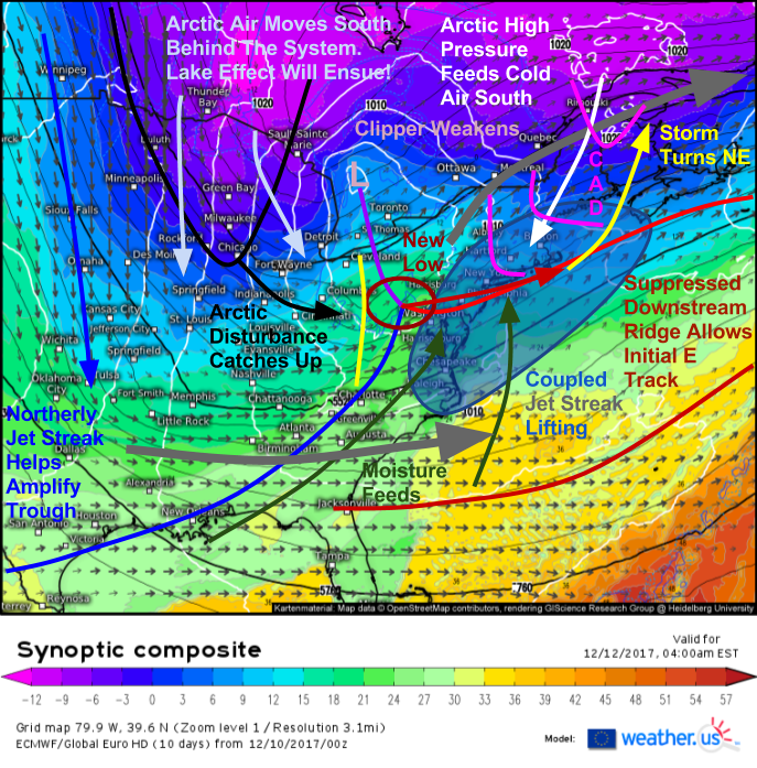
Here is the ECMWF’s synoptic composite map valid early Tuesday morning. I’ve added annotations to highlight some of the more important synoptic (large scale) features. Below I’ll isolate each of those features on their respective pressure levels, but the nice thing about the synoptic composite is that it puts the whole setup together.
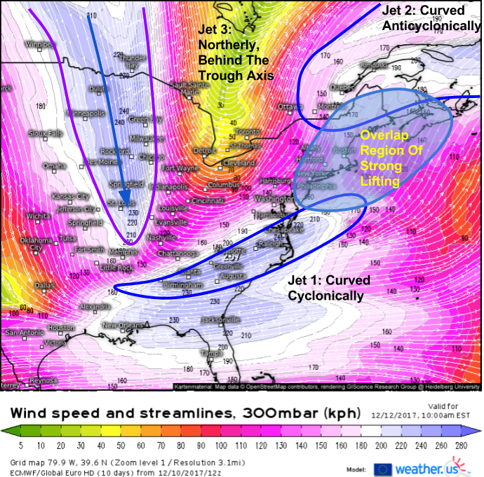
Starting near the top of the atmosphere, we have a classic jet stream setup.
Three jet streaks are noted in the forecast for 300mb on Tuesday morning. They will all work together to produce heavy snow in New England. The first stretches from the Lower MS valley through the Southeast and ends just south of Cape Cod. This streak is curved cyclonically, meaning it turns counterclockwise, just like winds near low pressure systems (cyclones). In a cyclonically curved jet streak, rising motion is greatly exaggerated in the left exit region, located on the poleward side of the eastern half of the jet. This means that the area from Philadelphia to the Maine Coast to the waters off Cape Cod will see strong lifting on Tuesday morning.
The second jet streak is anticyclonically curved, meaning it turns clockwise like winds near high pressure systems (anticyclones). In an anticyclonically curved jet streak, lifting is greatly exaggerated in the right entrance region, located on the equatorward side of the western half of the jet. Look at where this area is located. It’s almost the exact same as the area favored for lifting from the first jet! The layering of jet streak dynamics amplifies their effect, and this area is favored for very strong rising motion. Unsurprisingly, this is where rapid low pressure development and heavy precipitation is expected.
The third jet streak won’t be directly involved, as it is located much farther west, but it will still play an important part. The strong northerly winds blowing down the Midwest will be transporting cold air southward. This cold air advection will help to deepen and amplify the trough to the east. This deepening and amplification will help support the storm developing off the East Coast.
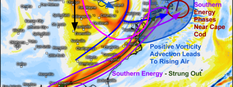
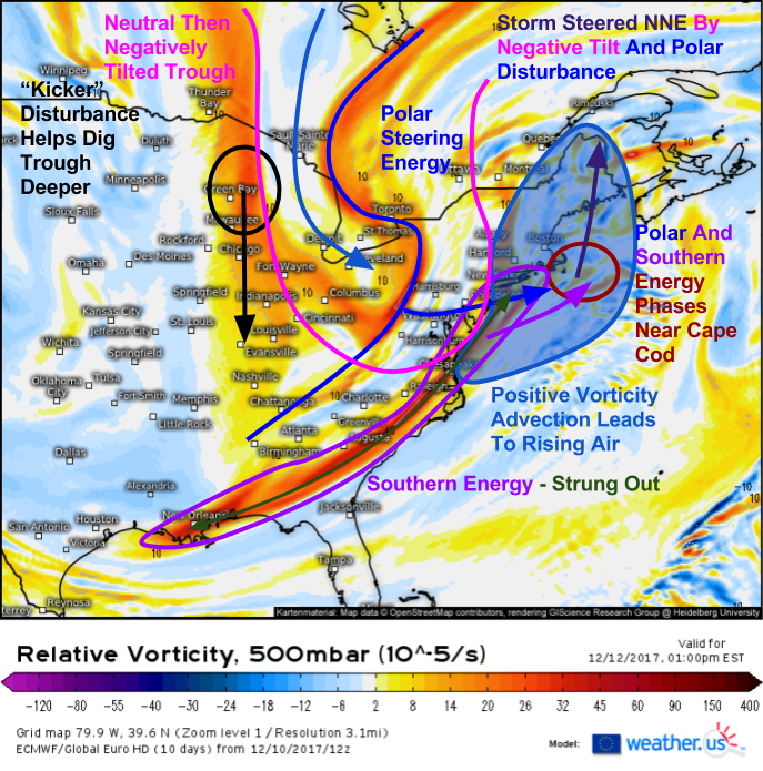
Moving down through the atmosphere, here’s a look at what’s happening at 500mb. This is the middle of the atmosphere, below the jet stream but above the highs, lows, and fronts that we see at the surface. There are a number of things going on here, many of which are favorable for storm formation and subsequent intensification. Near Green Bay, a strong disturbance will be diving south. This will, along with the jet streak discussed above, help to carve out the upper level trough to the east. In the middle, we have our polar energy that is anchoring the whole setup from Toronto Canada. The southern part of this energy will be driving east on Tuesday, where it will encounter another disturbance. It’s this southern disturbance that’s not looking so good according to current forecasts. Notice how it’s strung out, from New England to New Orleans. This will keep the storm from doing anything too crazy, as unified systems are capable of much more than divided, strung out ones.
One benefit to the strung out energy is that there can be a much wider area of what’s called “Positive Vorticity Advection” or PVA for short. PVA is one of the processes that results in rising motion in the atmosphere. Advection is just a fancy way of saying that something (warm air, dry air, vorticity, etc.) is being blown by winds from one area to another. In this case, strong southwesterly winds are transporting vortity from the Mid Atlantic to New England, resulting in rising motion along the way. As the trough becomes tilted on a NW-SE axis (with a negative slope, hence “negatively tilted”), polar energy will “phase” with the northern part of that southern system. This will result in a strong disturbance moving towards Cape Cod. As a result, this becomes the favored location for secondary low pressure development during the middle of the day Tuesday.
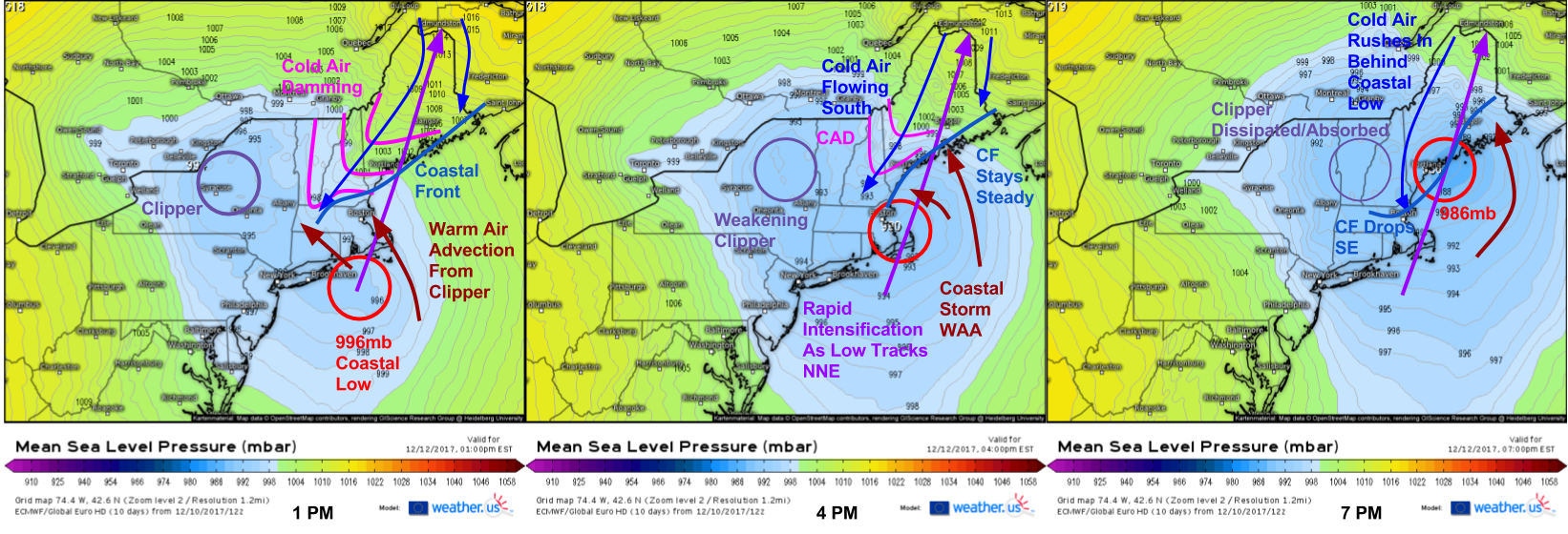
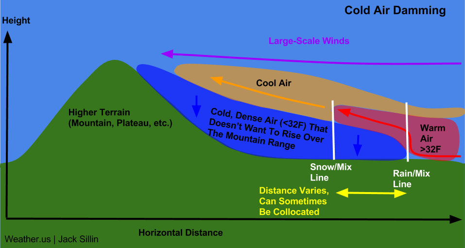
Here’s the ECMWF surface pressure progression on Tuesday afternoon. Over the course of just 6 hours, the clipper goes from fully controlling the setup to the coastal low resulting in the clipper’s demise. The coastal low will undergo an impressive bout of rapid intensification, with pressure falls of >10mb in 6 hours expected. There are a number of other features also visible on the surface pressure maps. Notice the kinked isobars (lines of equal pressure) over Maine and New Hampshire. This localized ridge of high pressure is indicative of cold air damming. Cold air damming happens when winds are pointed normal (perpendicular) to a mountain range, and those winds are trying to kick out entrenched cold air.
This is a schematic that shows how cold air damming works, and how it can be crucially important for precipitation type forecasting. In the case of Tuesday’s event, the higher terrain is the Appalachian Mountain range, most notably the White Mountains of New Hampshire. The warm air is moving in from the southeast, a wind direction that is perpendicular to the NE-SW orientation of the mountains. We have a perfect CAD setup! One important thing about CAD is that models tend to underestimate its staying power. The SE boundary of a CAD setup in New England is a coastal front. On the NW side of the coastal front, temps are below freezing while winds are out of the north. SE of the front, SE winds bring warm air in and change precipitation to rain. Models tend to move this coastal front much farther NW than it ends up. Especially on the southern and southeastern edges of a CAD setup, models have a notoriously strong warm bias. Remember this when looking at model guidance for Monday and Tuesday.
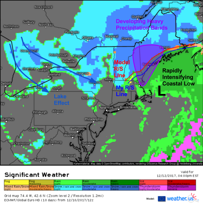
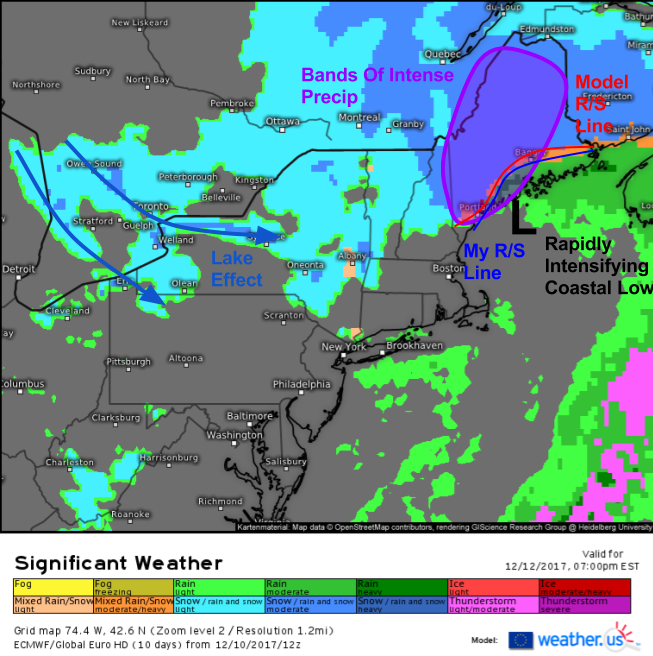
So how is this storm expected to evolve? Let’s look at a quick selection of ECMWF significant weather forecasts. I’ll point out some of the notable impacts and features, but won’t go over every frame. You can check them out yourself at weather.us!
The event will start on Tuesday morning as the clipper approaches. The dome of low level cold air discussed above will be in place, and as warm air begins to move north, it will rise up and over that cold dome, resulting in snow. Initially, it will be cold enough for snow as far south as Connecticut and perhaps even NYC. Boston will also start as snow. However, due to the forcing for precipitation (large scale warm air advection), snow won’t be overly heavy and only a few inches are expected at best.
By Tuesday afternoon, the coastal storm will be rapidly intensifying. Snow will have changed to rain and ended across Southern New England, but across New Hampshire and parts of Western Maine, dynamics associated with the back side of the intensifying storm will result in developing bands of heavy precipitation. Most of this will fall as snow, though along parts of the coastline from Boston north to the Maine Midcoast/Downeast area, temps will be warm enough for rain. I’ve marked where the ECMWF model thinks the rain/snow line will be at 4 PM, and where I think it will be. The difference is only 20-30 miles, but it will make a big difference for places like Portland.
By Tuesday evening, the heavy rain and snow will continue across parts of Maine, but precipitation will be ending elsewhere. As cold air pours in behind the storm, lake effect snows will once again get going downwind of Huron, Erie, and Ontario. Snow will end early Wednesday morning across parts of Maine as the storm continues to intensify over Atlantic Canada.
I’ll have more information on accumulations and other, more specific, timing and rain/snow line details tomorrow.
I’ve gotten many of these graphics using our custom domain tool, instructions for which are given in this video. For more information on the synoptic composite, check out this video. If there are any concepts in this post you want more information on, leave a note in the comments and I’d be happy to explain further!
-Jack



Where’s the Norlun trough? And the cats and dogs?
Thank you for the best explanation of (insert catch phrase moniker for this type of storm here: Clipper Nor’Easter?). I now look forward upcoming winter storms!
Way to go Jack. Excellent! I am starting PSU in January getting my certificate in weather forecasting in 2 years. I appreciate your knowledge and teaching skills.
Thank you!
Great blog Jack! I live in Portsmouth NH and have seen these coastal fronts wreak havoc with forecasts. I expect this storm to be one of those where a few miles makes a huge difference in my area. Keep up the good work!