Rain Mixes With Snow In The South, Lake Effect Continues In The Great Lakes
Hello everyone!
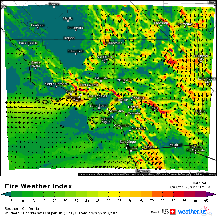
There’s lots of weather to discuss today! Rain across the south will mix with and change to snow today as Arctic air moves south. Farther north, more snow is expected in the Great Lakes. The southern side of the cold front bringing snow to the south will feature severe storms in parts of Florida, and the environment appears favorable for a tornado or two. Quiet weather is expected for the rest of the country, and thankfully the most dire fire weather appears to have passed for Southern California, though NE breezes will still make firefighting a challenge.
The national radar composite highlights where precipitation is ongoing right now. Lake Effect bands are clearly visible downwind of Ontario and Erie, while the band of snow near Michigan is a result of a strong upper level disturbance moving southeastward. Across the south, rain and snow stretches from Virginia to Mexico. The band producing heavy snow is currently located in the Houston area, and it will be moving east today.
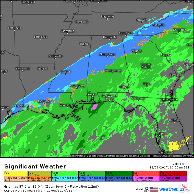
Significant Weather forecasts for later on this morning show snow falling from Galveston Texas up through central MS, AL, and northern GA. This won’t just be flurries, a band of moderate to occasionally heavy snow is expected similar to what happened in Texas last night. Under this band, dynamic cooling processes will allow for accumulation despite currently warm temperatures in the mid 30’s. 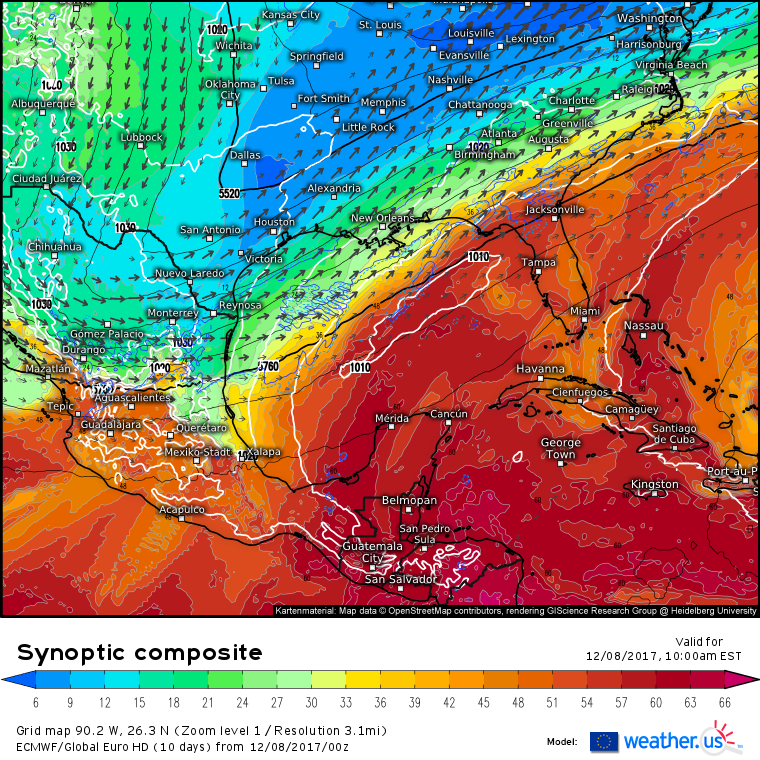
The ECMWF’s synoptic composite map (what’s that and how do I use it?) shows why we’re able to get snow in the deep south today. There’s a very noticeable kink in the 500mb height (black) lines over Texas. This is a strong upper level disturbance. Out ahead of it, rising air will fuel the development of an area of low pressure, visible as the elongated, but closed, white circle over the Gulf of Mexico. Most importantly, there’s a supply of cold air available as shown by the blue shading reaching from the Ohio Valley all the way to Houston.
The contrast between this cold air, and the deep tropical moisture over the Gulf of Mexico (red colors) is another factor that is helping to support the snow. This is known as a baroclinic gradient, and has immense amounts of potential energy stored up that can be released if an upper level disturbance is present.
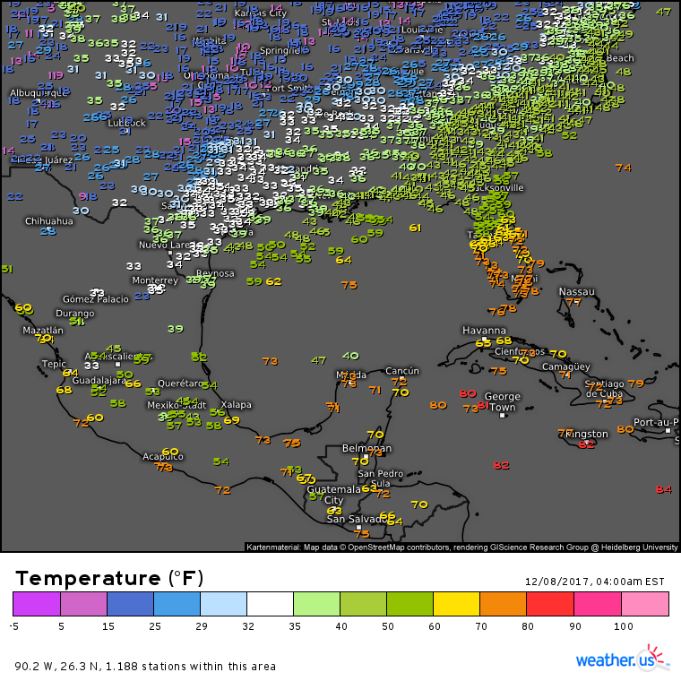
You can see this gradient present in current observations, which show temps near 15 degrees in Central Texas, while stations in the Central Gulf of Mexico are reading a balmy 75 degrees. Finally, an analysis of the vector field shows a strong jet streak extending from Northern Mexico to the Ohio Valley. The areas we’re interested in for snow today are located in the right entrance region of this jet, a location notoriously favorable for rising motion and precipitation.
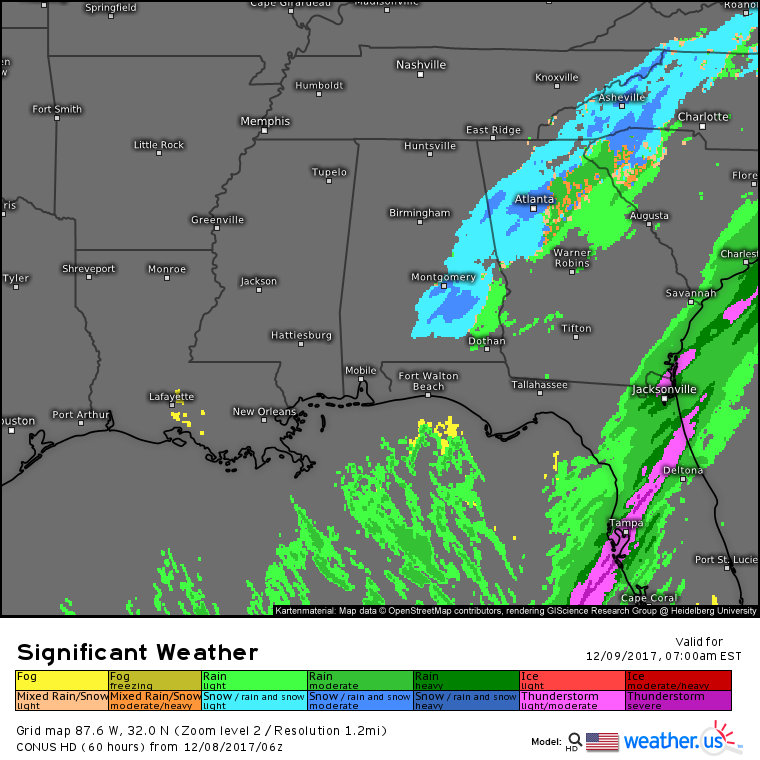
Snow is expected to continue into tomorrow morning for parts of Alabama and Georgia as a storm system begins to take shape just offshore. The dynamics on the back side of that system will keep precipitation going even as colder and colder air rushes south. If you’re looking for snow tonight SE of Atlanta and don’t see it, you may have a better chance tomorrow morning!
The upper level disturbance, and its associated low pressure area, will approach the East Coast tomorrow. The result will be an intensifying coastal storm that will bring a moderate snow event to a fairly wide swath of the eastern part of the Northeast and Mid Atlantic. The map above shows the developing storm (white circles) located out ahead of a strong upper level disturbance (kinks in black lines), in the right entrance region of a very strong jet streak, and right along a strong baroclinic gradient. All the ingredients are set up for snow as cold air has moved into the area behind the cold front from earlier in the week.
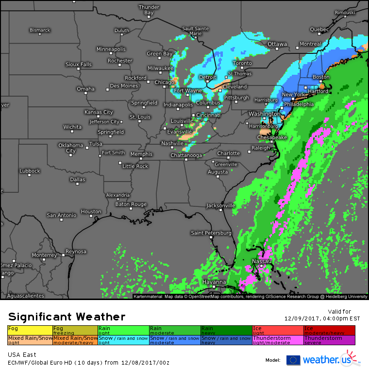
Sure enough, ECMWF significant weather forecasts show snow falling from Maine to Washington DC tomorrow afternoon as the storm develops offshore. There remains a bit of uncertainty as to how far NW the precipitation shield makes it, and how heavy the snow will fall along the coastal plain. There’s also the chance of some mixing for places like Cape Cod and Long Island which would cut down on accumulation potential.
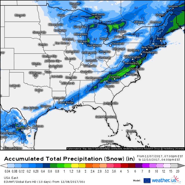
While accumulations won’t be overly high, this system will provide a solid first snow for much of the Northeast and Mid Atlantic. ECMWF liquid equivalent precipitation forecasts (what’s that?) show a widespread area of .4″ (>4″ of snow) from Maine to NYC to DC and back into the south, where that amount of liquid won’t go quite as far for accumulations. However, for many, .5″ appears to be the ceiling for this event. That would equate to 4-6″ of snow, depending on the location.
There are some hints that higher QPF (Quantitative Precipitation Forecast, another way of saying liquid equivalent precipitation) could fall across the southern Mid Atlantic, but with warmer temperatures, the liquid equivalent won’t go nearly as far as it will in New England. The highest totals will likely be found in NE Maine where the best combination of cold air and liquid equivalent precipitation is located. I’ll have much more on this system tonight and tomorrow morning.
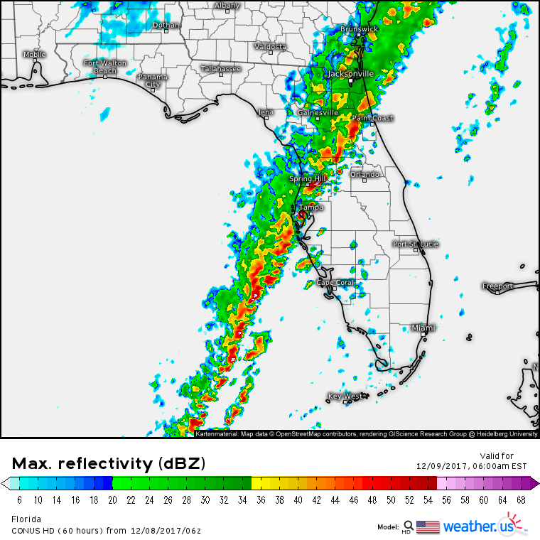
Snow won’t be our developing storm’s only impact. As the system develops off the Southeast coast, it will force the cold front that moved through the rest of the country earlier in the week to drop south across Florida. With deep tropical moisture in place ahead of the front, and strong dynamics associated with the system itself, strong to severe storms are expected early tomorrow morning across much of the Florida peninsula.
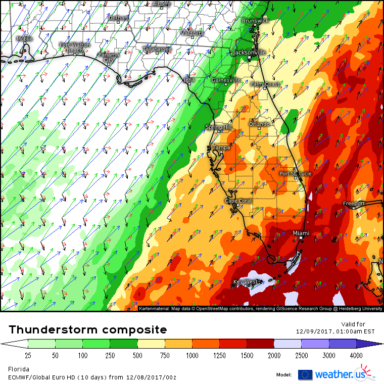
The ECMWF’s thunderstorm composite (what’s that?) highlights tonight’s setup in Florida. The front is clearly visible as the CAPE (what’s CAPE?) gradient from zero CAPE behind the front where temps are in the 40’s, to 1,000 J/kg of CAPE ahead of the front where temps are in the 70’s. A look at the vectors ahead of the front shows winds accelerating and veering with height. Weak SSW winds near the surface (black arrows) become strong SW winds aloft. The average of all the vectors comes out with a southwesterly direction, parallel to the front. As a result, the favored storm mode today will be linear, but if any discrete cells can develop ahead of the line, they will be in an environment favorable for tornadoes. Storms will move offshore with the front tomorrow afternoon.
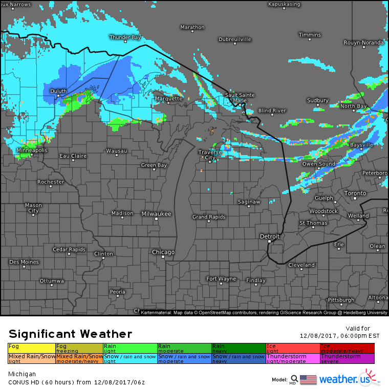
As the day wears on, the lake effect scene we’ve had locked into place for the past couple days will shift a little bit. A strong clipper system will be moving into Minnesota, and will bring light to moderate snow to parts of the Great Lakes this evening. Ahead of this system, the lake effect machine will be put on pause as winds temporarily shift to the southwest. After that system passes by, a renewed shot of Arctic air will kick the lake effect snows back into high gear, especially for Lake Superior where the greatest lake-air temperature differential will be found. For more on why that’s important, and more on lake effect in general, check out this blog post discussing lake effect snow.
Out west, the most extreme fire weather is over for Southern California. The Swiss Super HD Fire Weather Index forecast shows values ranging from 75 or 80 on the ridges to lower values along the coastal plain. This, while still significant, is less extreme than yesterday’s widespread values of >95. The relaxation is mostly due to a reduction in winds today compared to yesterday. Wind gusts could still exceed 50 mph on the ridgetops, but at lower elevations, much lighter breezes are expected. The conditions should allow firefighters to make some progress in containing the fires, but it will be a while before the all clear can be sounded.
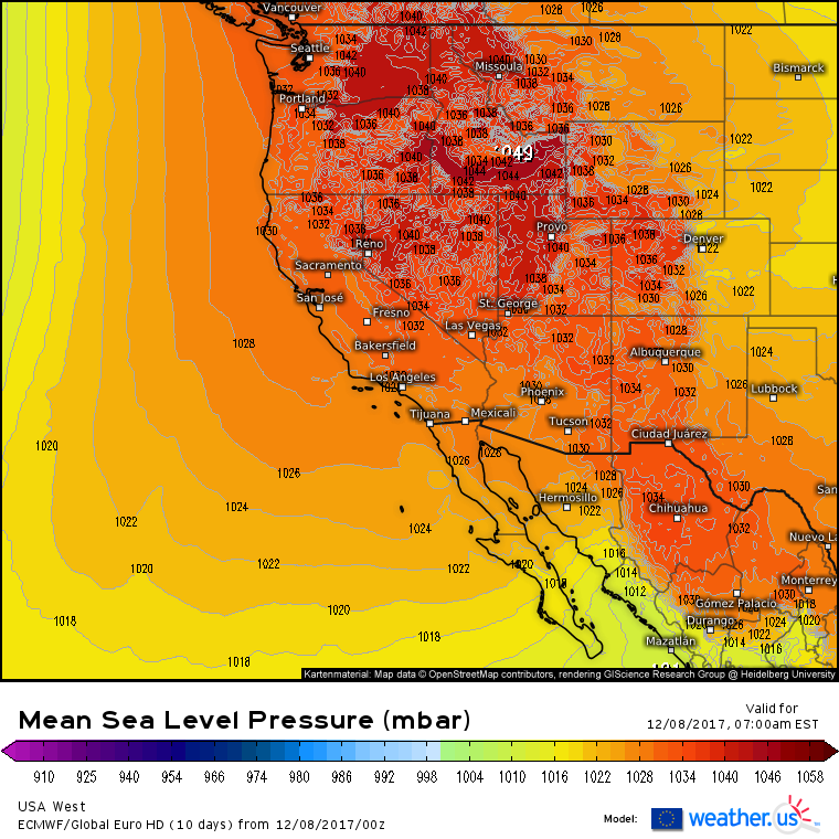
Elsewhere across the country today, more clear and dry weather is expected across the Pacific Northwest, Rockies, and Plains as very strong high pressure is in charge. Usually sea level pressures of 1050mb are reserved for the strongest of Arctic high pressure systems that contain very cold, very dense air. To see such pressures under a warm ridge is quite unusual!
For more information about your local forecast: https://weather.us/
For more information about the local forecast for ME/NH: https://forecasterjack.com/2017/12/08/cool-and-calm-today-4/
-Jack

