Jose Will Bring Rain And Wind To The Northeast And Mid Atlantic This Week As Maria Continues WNW
Hello everyone!
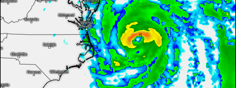
The forecast for Jose continues to increase in confidence, at least through the coming week. The storm will move north, bringing high winds and heavy rains to coastal parts of the Mid Atlantic and Northeast during the middle of the week, before turning east away from the US. Beyond that, there’s low confidence in Jose’s track, however it will be much weaker after spending several days over the cold waters near New England. I’ve gone over some of the meteorology behind Jose’s forecast in the past few days, this update will focus on the expected impacts and the meteorology behind those.
Click on any link for more information about a particular topic. For each link, you can click the map to zoom in, you can click near the edge of the map to pan, and you can use the (-) button to zoom out. You can also explore other parameters/satellite views and time steps via the menus to the left of each image.
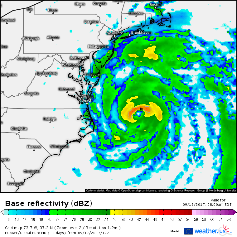
The outer bands of Jose will arrive on the coast between Boston and Cape Hatteras on Tuesday morning. These bands will feature breezy conditions and light/moderate rain. Overall, impacts on Tuesday will be minimal as rain bands continue to rotate onshore.
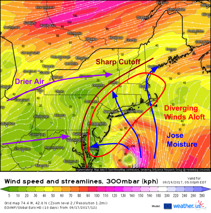
Upper level wind forecasts from the ECMWF model show why we can expect bands of heavy rain to rotate inland Tuesday and Wednesday, even as the center of Jose remains offshore. Winds in the upper levels of the atmosphere will be out of the southeast over coastal parts of the Mid Atlantic and Northeast. Inside this envelope of moisture, air will be rising due to air parcels diverging in the upper levels. Diverging winds at the top of the atmosphere creates an area of low pressure which air parcels from the lower levels have to rise to fill. This rising motion leads to cooling and condensation, and eventually precipitaiton. There will be a sharp cutoff though, between this region of southeasterly winds and larger scale westerly winds associated with the jet stream. Those westerly winds will be carrying drier air, thus keeping most of PA, upstate NY, and VT dry.
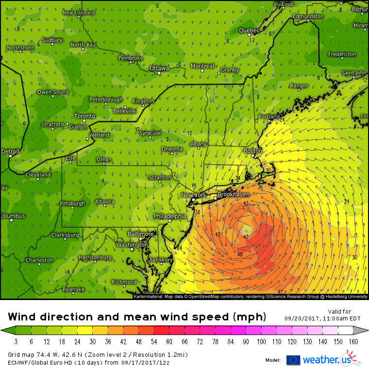
In addition to the tropical rains, winds will be quite gusty on Wednesday across parts of Long Island and SE New England. Sustained tropical storm force winds (40 mph+) are a distinct possibility across the eastern part of Long Island as well as Cape Cod and the islands of Nantucket and Martha’s Vineyard. Breezy conditions will be noted farther south along the coast as well as across inland parts of Southern New England, though it’s Long Island, Cape Cod, and the Islands that have the greatest chance to see the winds that are strong enough to cause power outages and downed trees.
The one impact that’s been a given since the beginning hasn’t changed. Very large waves will pound all ocean facing beaches in DE, NJ, Long Island, RI, and MA. Beach erosion will be an issue for the typically at-risk areas, and rip currents will continue to be a hazard for anyone attempting to enter the water. Additionally, astronomically high tides will fuel coastal flooding concerns for low-lying areas as persistent onshore winds push a slight storm surge into eastern MA and the Long Island Sound. Waves and surge will gradually subside on Thursday as the storm weakens.
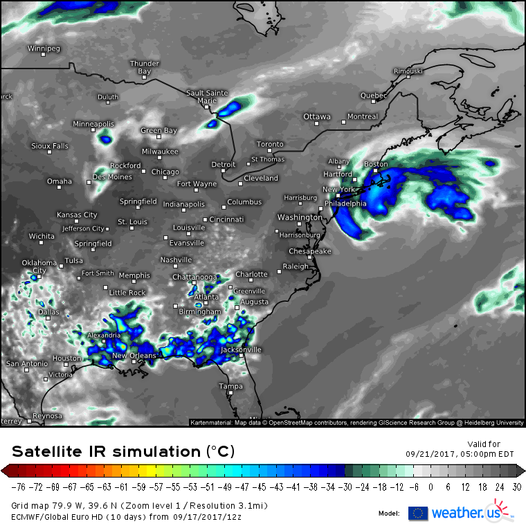
Jose will become a bit trapped between upper level systems on Thursday. As a result, it will linger off the New England coast while weakening due to the cold waters in the region. The only area still feeling impacts by the time we get to Thursday will be MA, SE of Boston where gusty showers will continue. Showers and winds will both be subsiding across the rest of the Northeast and Mid Atlantic.
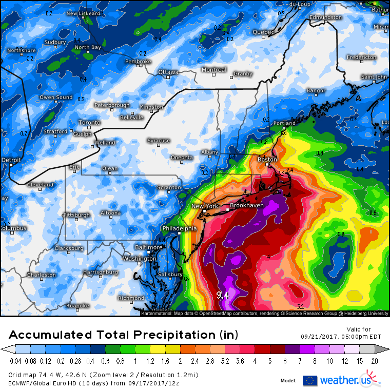
The envelope of favorable rainfall conditions discussed above shows up well in the total rainfall forecast from the ECMWF. The heaviest rainfall will likely be on Cape Cod and the adjacent islands of Nantucket and Martha’s Vineyard. Rainfall here could reach 6″. A broader swath of 2-4″ is forecast from Coastal NJ up to NYC and over towards Boston. Cities like Portland, Albany, Philadelphia, and Washington DC will be on the fringes of the system with little to no rainfall NW of those areas. For more on the rainfall forecast for your town, check out our location based ensemble forecasts or our Forecast XL tool. Curious what the Forecast XL tool is, how to use it, and why it’s useful? Check out my video explaining.
While Jose’s impacts are locked and loaded, there’s much more uncertainty regarding the next tropical system, Maria.
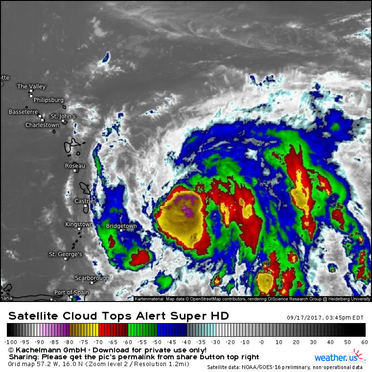
Maria has been struggling with a little bit of dry air today, but has improved significantly in terms of convective activity. Deep thunderstorms with cloud tops below -80C are now noted over the center, a sign that the storm may be poised to rapidly intensify (what do cloud top temperatures and satellite imagery tell us about the strength of a storm? Check out this video explaining satellite imagery and how to use it here at weather.us). Strong spiral bands are noted to the east of the center, though a dry slot continues to show itself just to the north and west of the center. For any really impressive intensification to occur, this dry air will need to be mixed out by the system. To what extent that will happen is still a bit uncertain, but other parameters such as water temperature and upper level winds are very supportive of intensification as Maria moves WNW towards the Lesser Antilles.
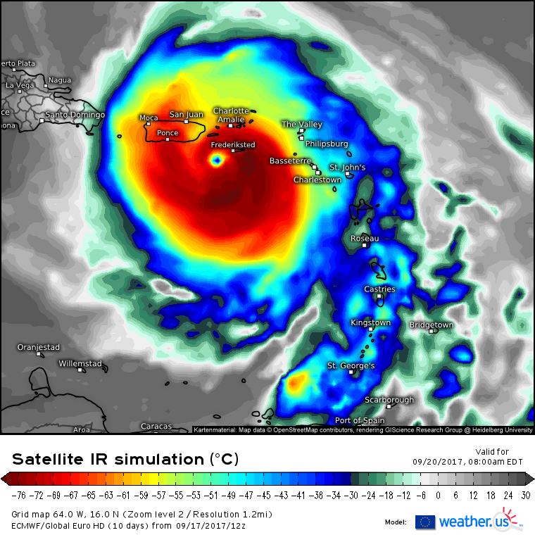
Maria is forecast to be a strong hurricane as it moves towards Puerto Rico on Wednesday. While the exact intensity will depend on how quickly the dry air near the system can be mixed out, confidence is high that Maria will bring very dangerous conditions to Puerto Rico by the middle of the week. High winds, heavy rainfall, and storm surge will all be issues to watch out for.
Maria will move north of Puerto Rico by the end of the week, at which point its future becomes quite uncertain.
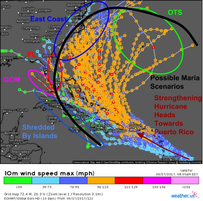
EPS ensembles show a very wide range of potential outcomes for Maria past day 4/5. Some guidance shows the storm moving west and dissipating over the high mountains of Hispaniola and Southern Cuba. Some guidance points to a Florida landfall or potentially even a track into the Gulf of Mexico. Many ensemble members point Maria up the eastern seaboard with impacts spreading all the way into the Mid Atlantic. Finally, the storm could of course recurve out to sea before impacting land. Curious about this map, ensembles, and how to use this data at weather.us? Check out my video on the topic.
So which of these many scenarios is most likely, and what are some of the players “under the hood” of the forecast here?
The upper level forecast map from the ECMWF for Thursday shows a complex and highly amplified pattern over North America. The jet stream (black) will be in what’s called a meridional flow pattern with high amplitude waves. This pattern is being driven by the recurvature of Typhoon Talim that was discussed a few days ago. Part of this pattern is a blocking high over the Great Lakes (bright red). This high will attempt to build eastward and connect with the Western Atlantic Ridge near Bermuda (dark red). However, Jose (dark blue) will stand in the way as it creates and keeps open a weakness in the ridge. How quickly Jose can either leave the scene or weaken will have a huge impact on how quickly the ridge can rebuild, and thus the track of Maria.
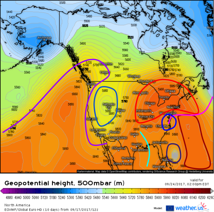
Here’s a general look at the pattern by day 7. This is just one model, so don’t pay too much attention to how it depicts any one piece of the puzzle. I show it here to illustrate that this is a complex puzzle, with many pieces and many unknowns.
The blocking high that is steering Jose is likely to be around over the northeast in some shape or form (bright red). Just how strong it is, and where it’s located will have a big impact on Maria’s track. Jose (or it’s remnants, highlighted in dark blue) will still be around too. The weakness in the ridge caused by Jose (pink) will be slowly disappearing, but if Jose is stronger or farther east than the ECMWF forecasts, that opening could be larger. The West Atlantic Ridge (dark red) is likely to be a factor as well, as it almost always is with tropical cyclones in this part of the world. If the WAR is as strong as forecast by the ECMWF, it would be really hard to see Maria escaping out to sea. There are some hints that there could be some upper level energy over the Gulf of Mexico or the Southeast US (bright blue), similar to what we saw with Irma. Just to add some extra chaos into the pattern, the ridge and trough over the West Coast (purple and lighter blue) may be undergoing what’s called an Anticyclonic Wave Breaking event which is where a wave-shaped anticyclone (high pressure system) breaks over a low pressure system. Models are notoriously bad at forecasting these events, which makes this an even lower than normal confidence forecast.
Any potential direct US impacts from Maria wouldn’t be for another 7 to 10 days, so there’s plenty of time to watch this system. I’ll have many more updates as we start to figure out the intricacies of this complex pattern!
-Jack
