Major Hurricane Irma Makes Landfall In Cuba, Will Head For Florida Tomorrow
Hello everyone!
This morning’s update will be focused on all things tropical as the main story across the US continues to be Major Hurricane Irma. If you’re looking for your local forecast, find it over at weather.us.
Click on any link for more information about a particular topic. For each link, you can click the map to zoom in, you can click near the edge of the map to pan, and you can use the (-) button to zoom out. You can also explore other parameters/satellite views and time steps via the menus to the left of each image.
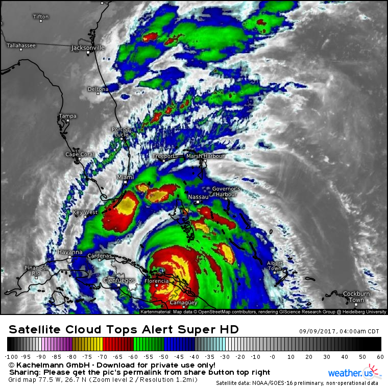
Irma restrengthened into a Category 5 system last night, then made landfall in Cuba. Due to interaction with Cuba, the storm has weakened this morning and that is clearly evident on satellite imagery.
Notice the much warmer cloud tops all around the storm. There’s a significant area of dry air just to the west of the core, and the coolest cloud tops are found well away from the center in the spiral bands near Florida. Nevertheless, the storm’s structure remains more or less intact. The eye still exists inside an eyewall, albeit a weaker one. There’s still strong upper level outflow, and spiral bands extending out from the center. While Irma is bruised, she’s far from beaten.
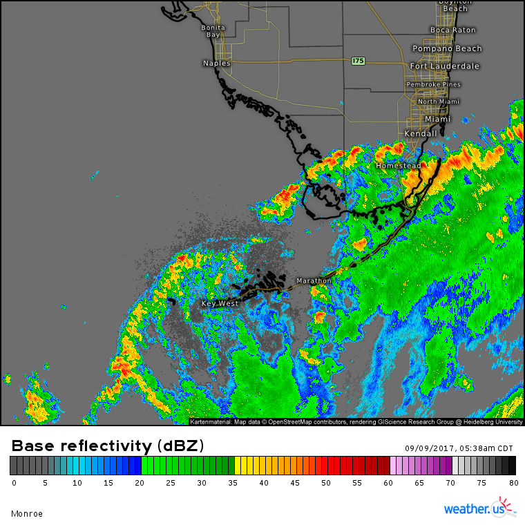
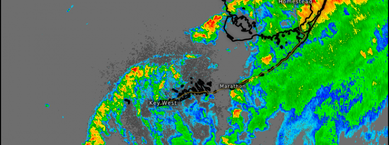
Impacts from Irma are already well underway in the Florida Keys as the outer bands move in. Winds are gusting to tropical storm force in the Keys meaning that all preparations should be 100% complete this morning. Conditions will continue to deteriorate today and tonight.
Notice how the radar signatures of some of these storms look like radar signatures from a severe weather day. A hurricane’s circulation causes wind shear to develop in the outer periphery of the storm. Wind shear is an important ingredient in severe weather, and therefore severe storms are expected over Southern Florida today. The area is in a slight risk from the SPC, with the main threat being tornadoes due to the unusually large amount of rotation in the atmosphere.
What’s the future of the storm from here?
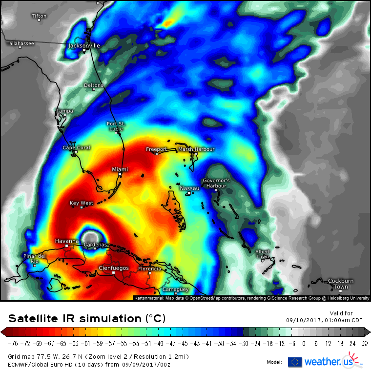
Irma will move over the northern coast of Cuba during the day today, before re-emerging out over water tonight. Any wobbles to the north or south will be very important today. A wobble to the north, even by 30 miles, would put the core of the system back over water. A wobble to the south, even by 30 miles, would put the core of the system over land. Either way, ECMWF simulated satellite shown above indicates that the storm will turn north late tonight and emerge out over water. At this point, the race is on to get the storm to Florida before it can strengthen too much.
How does the environment look for strengthening north of Cuba? There are three factors to consider: ocean temperatures, mid level moisture, and wind shear. We already know that the water in the Florida Keys is warm, plenty warm enough to support a strengthening tropical cyclone.
How about the mid level moisture?
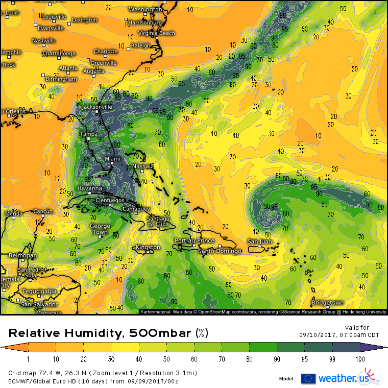
ECMWF data shows a large area of dry air to the west of the system tomorrow morning. Dry air is also trying to sneak in from the southeast. While you can see that no dry air is making it into the inner core, it’s certainly knocking on the door. This highlights that Irma will have a window to strengthen, but that window will be closing fast as she approaches the Florida coastline.
How about wind shear? That too will be on the increase.
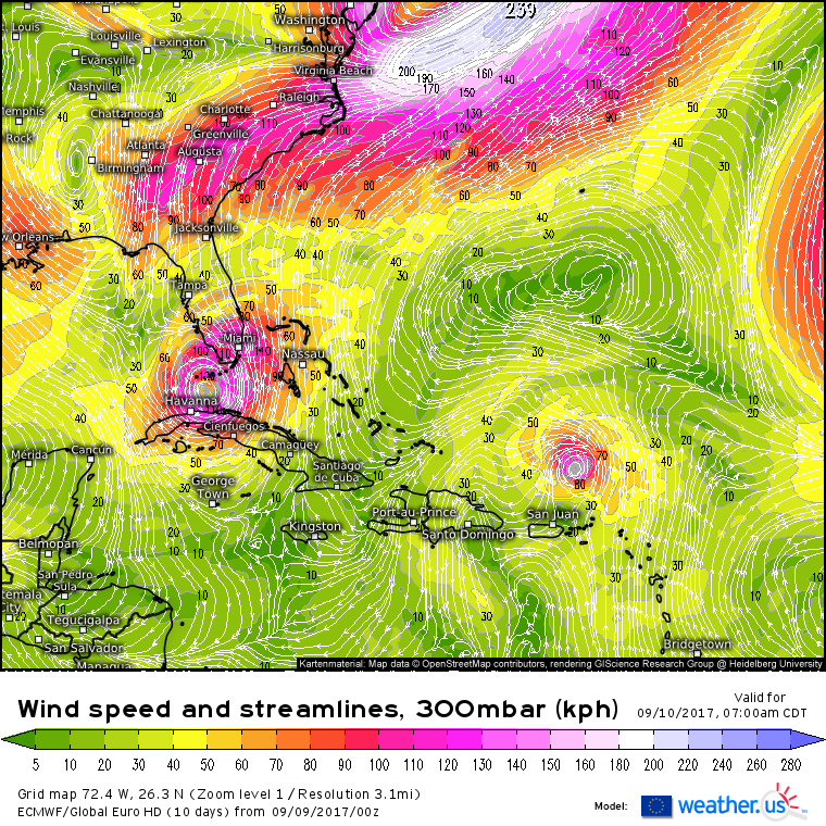
On this map, which is the wind speed and direction at 300mb (the upper atmosphere) according to the ECMWF model, you can see Irma nearing Key West. You can also see some stronger winds over New Orleans associated with a bit of an upper level low near Birmingham Alabama. This upper level low is going to steer Irma N and then NW, but it will also bring some wind shear near the system. While you can see that tomorrow morning, that shear hasn’t made it to Irma yet, it’s not far off.
Both the mid level moisture and the upper level winds indicate that Irma has a window of opportunity where it could strengthen tomorrow as it moves north. However both of those parameters, as well as its forecast track, indicate that the window for strengthening will be closing fast. It will be a race against time, and it remains to be seen who will win.
However, it’s very important to note that for Florida, the differences will be fairly minimal. A 130 mph storm will cause less damage than a 160 mph storm, but that doesn’t mean it’s something to take lightly. 130 mph winds caused immense destruction and utter devastation in the Rockport/Port Aransas area as Harvey made landfall just a couple weeks ago. Ask the people who lived through that and they will tell you not to mess around with a storm that’s “just” a Category 4.
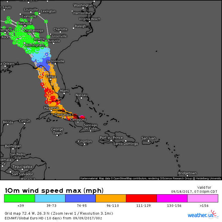
As for the track forecast, the ECMWF ensembles (as well as the deterministic runs of the GFS and ECMWF) have continued their shift west in track. What are ensembles and how do I use this data? Check out my video on the topic to learn more.
The storm is now forecast to pass over Key West before moving north towards the Tampa area. Because of the angle of approach (parallel to the coast), the landfall location of Irma remains uncertain. A jog 5 or 10 miles east might mean a landfall location 50 miles south. Unfortunately, the overall message is that the storm will spread extremely dangerous conditions across all of the Florida peninsula, regardless of the exact town it makes landfall in.
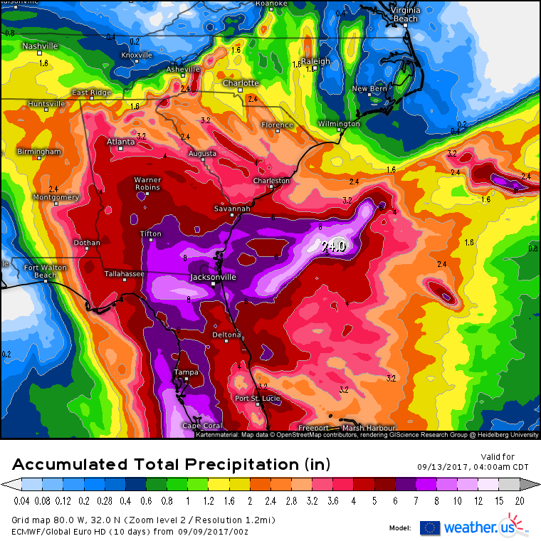
In addition to the winds and storm surge, rainfall continues to pose a large threat with Irma.
Along the path of the core, 8-12″ of rainfall is expected with locally higher amounts. Farther outside the core, a general 4-8″ is expected all the way up through much of Georgia and South Carolina before lighter amounts are found to the north, east, and west of the track of the system.
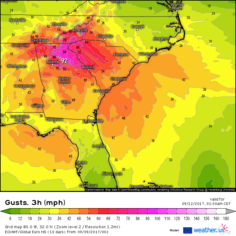
It won’t just be the rain that will cause problems well into Georgia. While land interaction will certainly slow Irma’s winds down, they’ll have a long way to fall before they’re harmless.
ECMWF data has been consistent in supporting the threat for hurricane force wind gusts all the way up into Northern Georgia While 75 mph wind gusts are a far cry from the 175 mph wind gusts expected in the Florida Keys, they’re certainly enough to knock down trees and cause significant damage to power lines. Folks all the way up I-75 towards Atlanta should be preparing today for the possibility that the power will be out for several days starting on Monday.
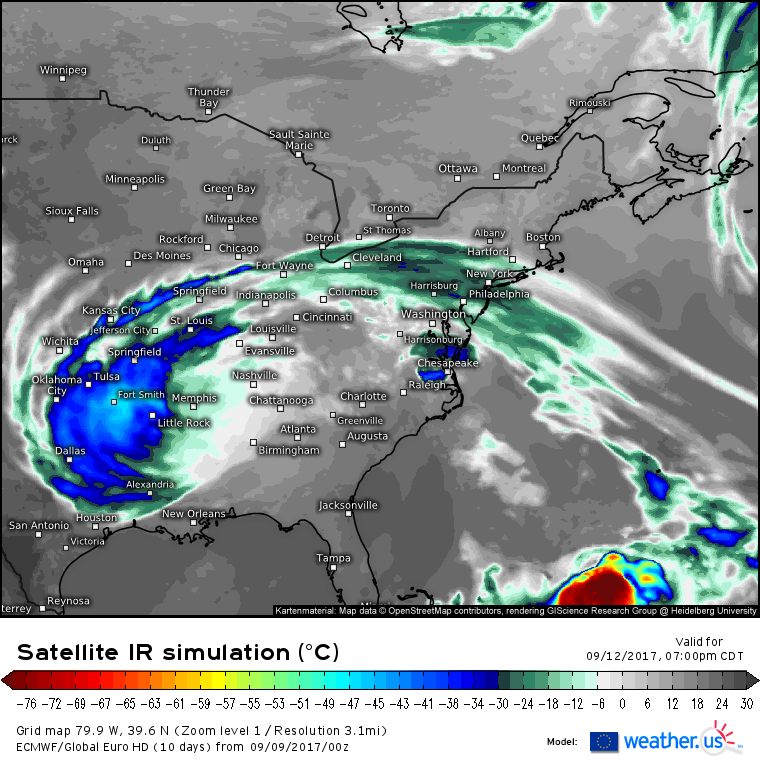
By Tuesday, Irma will be a tropical system no more. However it does appear to die a spectacular death over the interior Southeast as it spreads clouds and light showers across nearly half the country from Dallas to Chicago to New York. After Irma withers away, all eyes will be on that next blob in the bottom left of the simulated satellite image above. That blob is Major Hurricane Jose.
Where will Jose track?
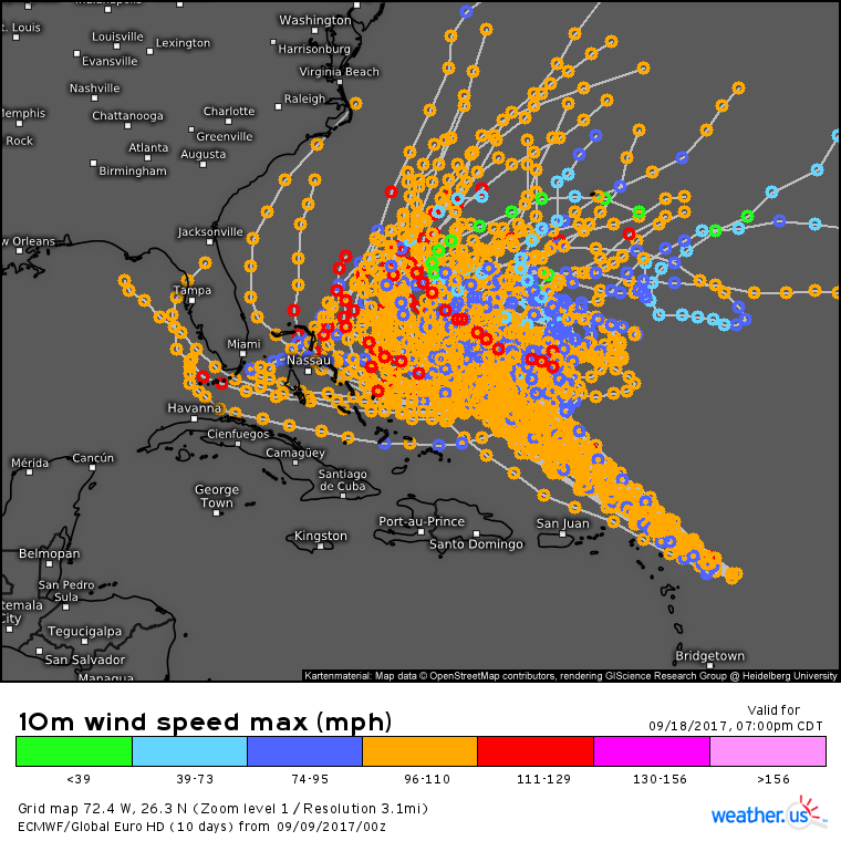
The ECMWF ensembles have an extremely wide spread in Jose’s track. Some members take the storm into the Gulf of Mexico, others up the East Coast, others out to sea, and some even loop the storm back to the Eastern Atlantic. At this point, it’s anybody’s guess, but note the very close spread indicating strong agreement in the short term. The short term tracks show the storm passing just a few miles from the same islands that got pummeled by Irma just a couple days ago.
What are ensembles and how do I use this data? Check out my video on the topic to learn more.
I’ll have more on both Jose and Irma this afternoon!
Jack Sillin is a weather nerd and forecaster who regularly writes for weather.us and 33andrain.com.
