Major Hurricane Irma Rumbling Towards Florida
Hello everyone!
The tropical Atlantic has exploded with activity in the past week. There are currently three hurricanes ongoing in the basin, all of which have winds in excess of 100mph, and all of which are threatening land. I’ll focus on the storm headed towards the US, Irma, but will also mention Jose and Katia towards the end of this post. Click on any link for more information about a particular topic. For each link, you can click the map to zoom in, you can click near the edge of the map to pan, and you can use the (-) button to zoom out. You can also explore other parameters/satellite views and time steps via the menus to the left of each image.
Let’s start with Irma, the storm forecast to wreak havoc on wide swaths of the Florida peninsula.
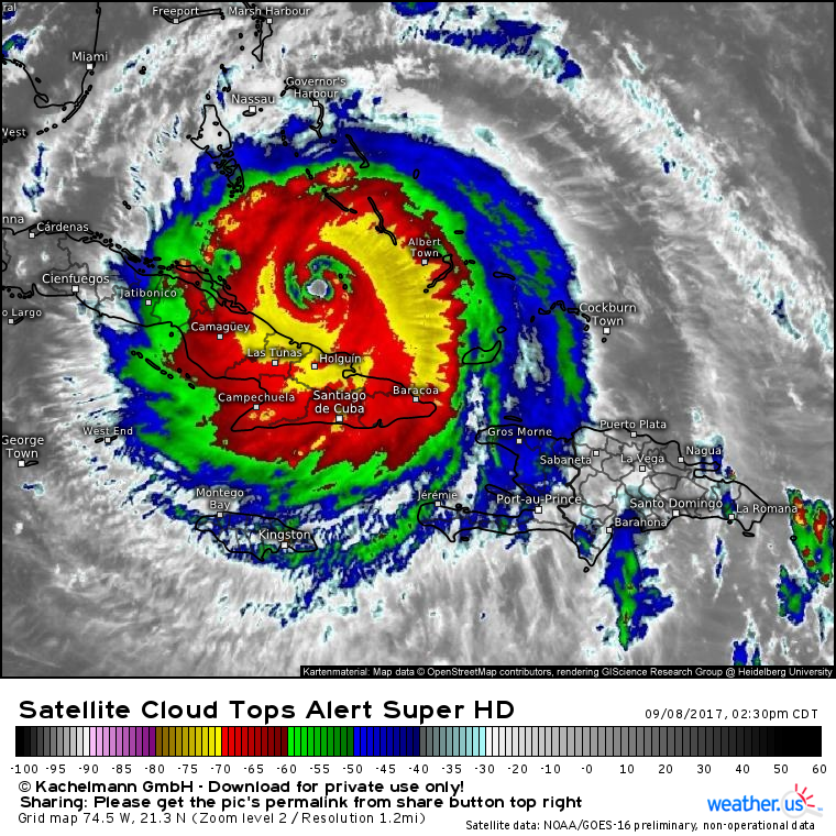
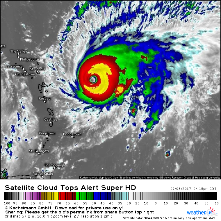
Irma’s satellite appearance is a bit ragged this evening, but in this case looks are deceiving.
Irma completed an eyewall replacement cycle last night. This happens when the innermost ring of thunderstorms in a hurricane’s eyewall spins too fast to stay organized. Once this happens, the innermost eyewall collapses and is replaced by the next ring of thunderstorms. It takes a little time for the inner ring to pass the baton so to speak to the outer ring of storms. Radar imagery from Cuba indicates this process has finished, but there’s still some cloud debris in the new eye that’s leftover from the old eyewall. This is what’s making the satellite appearance look a little ragged. I expect that these clouds will clear out tonight leading to a better looking system on satellite.
Where’s the system headed this evening? Satellite loops show a general WNW motion which will bring the storm very close to the coast of Cuba.
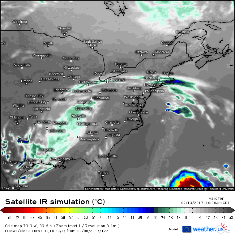
Model guidance has continued to shift south and west with Irma’s track today. As shown in the simulated IR satellite above, the ECMWF now shows Irma making landfall in Cuba tomorrow morning. Whether the center actually makes it onshore or not will depend on small wobbles that result from the storm spinning so fast. To visualize these wobbles, think of a top spinning across a table. The top may slowly travel from one side of the table to the other, but as it spins very quickly, it will make small wobbles along the way. Hurricane Irma will do the exact same thing, and those wobbles will mean the difference between a Cuba landfall or a close pass by to the north. If some of the farther SW models are correct and the eye can completely move onshore over Cuba for a period of 6 hrs+, some weakening could occur as the storm’s energy source will be removed.
However, this weakening would likely be short lived. After the storm turns north away from Cuba and towards Florida, the storm will move back out into an environment very favorable for strengthening.
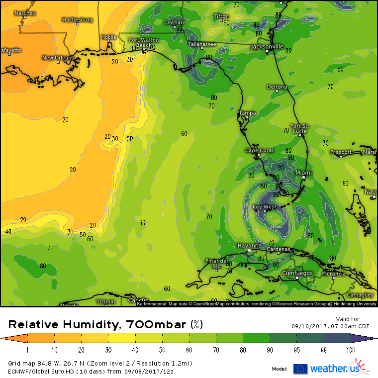
ECMWF mid level moisture maps show no dry air within several hundred miles of Irma as the storm moves north of Cuba. This is extremely favorable for strengthening. Ocean temperatures in this area are warmer than any waters Irma has passed over up until now. Wind shear will begin to increase ever so slightly as the system moves up the Florida coast, but it won’t be enough to stop intensification prior to landfall. Irma is likely to arrive in SW FL as a high end category 4 or low end category 5 storm. The difference between the two is minimal. Don’t get hung up on categories, I promise you won’t be able to tell the difference between 145 and 160 mph winds. Both will cause extensive wind damage in addition to storm surge impacts.
What’s the track forecast?
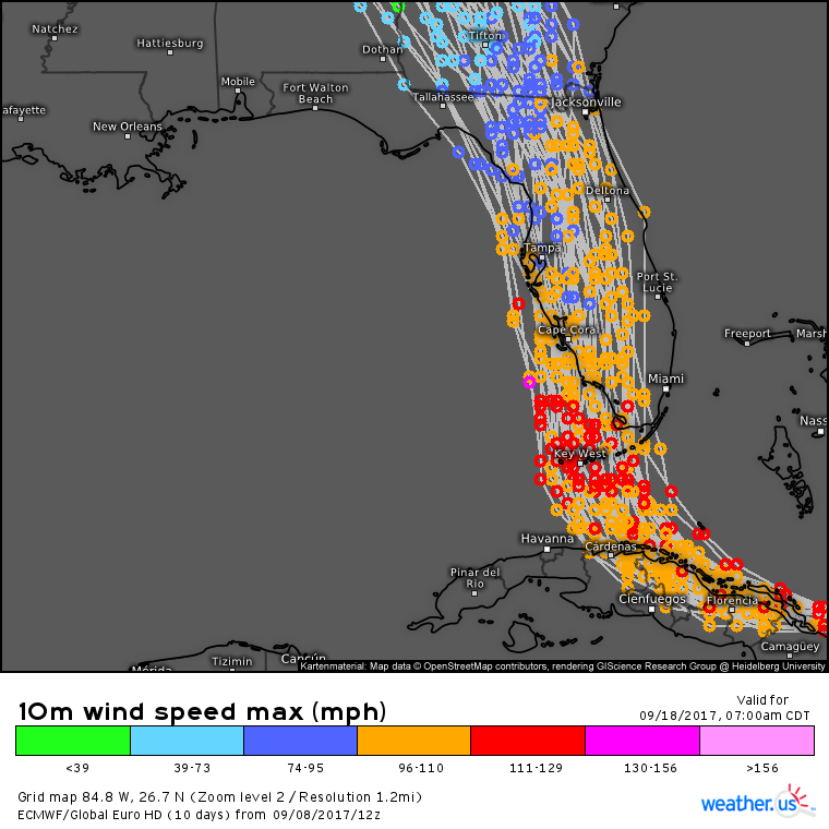
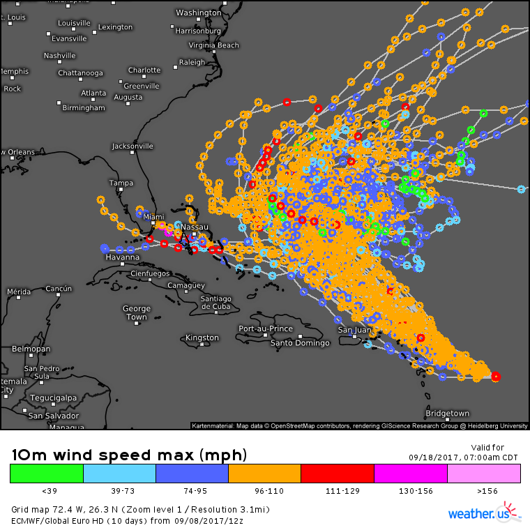
The ECMWF ensemble tracks have honed in on a basic idea for Irma, though some spread still remains. The hurricane will turn north after passing over or very close to the Cuban coast tomorrow. The core of the storm will pass through the Florida Keys on Sunday morning. The storm will track north on Sunday afternoon and will make landfall along the west coast somewhere in the vicinity of Naples. Notice in the image above that there remains some spread in terms of the track forecast for Irma. The exact center of the storm could make landfall anywhere from Homestead to Tampa. While this makes a huge difference for how much of the west coast sees extreme storm surge impacts, it makes little difference for the overall impact which will be extreme regardless of the precise track.
Let’s break down some of those impacts, starting with Irma’s extreme wind.
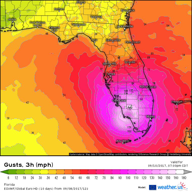
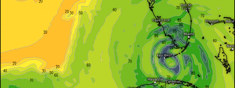
The ECMWF model pictured above highlights just how extreme Irma’s winds will be. In fact, I think these numbers here are better reflective of sustained winds than wind gusts, and even then the values displayed above may be an underestimate. The current NHC forecast is for sustained winds of 160 mph at landfall, making Irma a Category 5 storm. I certainly think the the environment is supportive of that forecast, highlighting where the models can underestimate the intensity of storms as strong as Irma. We’ve seen this low bias in intensity all week and there’s no reason to believe it won’t continue.
While certainly extreme, Irma’s winds will not be the only threat from the system.
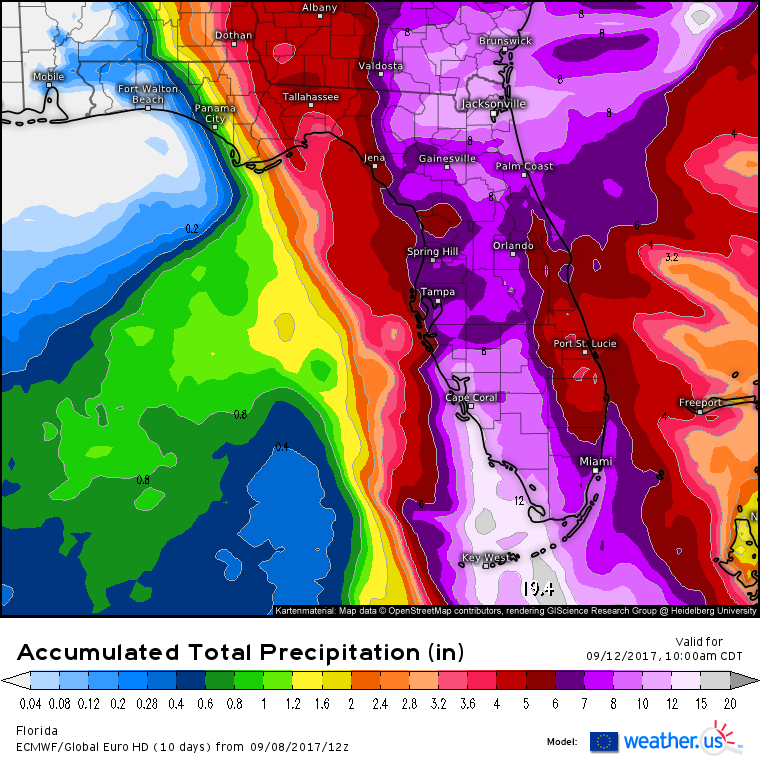
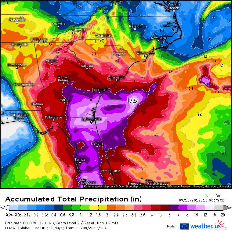
Heavy rains are forecast to accumulate over 6″ across the majority of the Florida Peninsula with higher amounts down in the Keys. While this is far less than the what we saw with Harvey, it’s certainly enough to cause some flooding. If you live in flood prone areas, prepare for water to enter your house as Irma moves through.
Freshwater flooding isn’t the only water related issue associated with Irma.
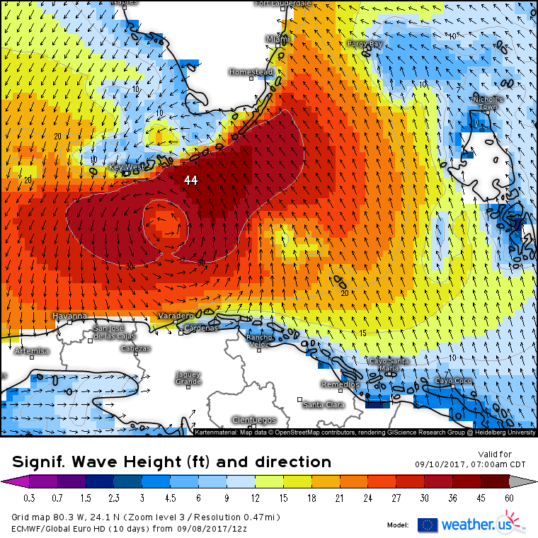
As the storm moves through the keys and towards SW FL itself, it will push a tremendous amount of water onshore in the form of large waves and storm surge. This map above shows forecast wave heights for the Florida Keys area on Sunday morning. Notice a very large area of 30-40 foot waves that will impact the Keys. Also note which direction they’re coming from: the southeast. Extremely strong south/southeasterly winds to the east of the storm will push a 6-10 foot storm surge into low-lying areas from Miami down to the Keys. As the storm moves north into SW FL, SW winds will push water into the coast of SW FL where storm surge inundation of 10-15 feet is expected.
As Irma moves north, the storm will weaken due to dry air, wind shear, and interaction with land. However, that doesn’t mean that areas farther north won’t see impacts.
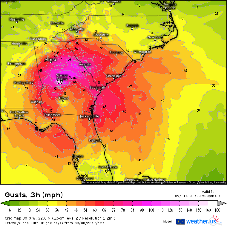
On Monday morning, the center of Irma will be moving into Georgia. While the winds will be decreasing at this point, some fairly severe impacts are still in store for parts of the southeast.
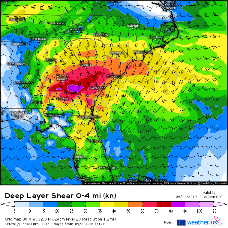
Hurricane force wind gusts will spread all the way into northern Georgia, South Carolina, and parts of the mountains of North Carolina. While these winds may be less than half the intensity of those that rake the Florida Keys, they’ll be strong enough to cause some significant issues in terms of downed trees and power grid impacts. Even though places like Atlanta might be hundreds of miles from where Irma makes landfall, these areas should still prepare for road closures and power outages due to downed trees not to mention the possibility of trees falling onto homes and businesses. Peak wind impacts for the Georgia area will be on Monday before the system begins to dissipate on Tuesday.
As with Florida, there will also be impacts from non-wind related threats such as rainfall.
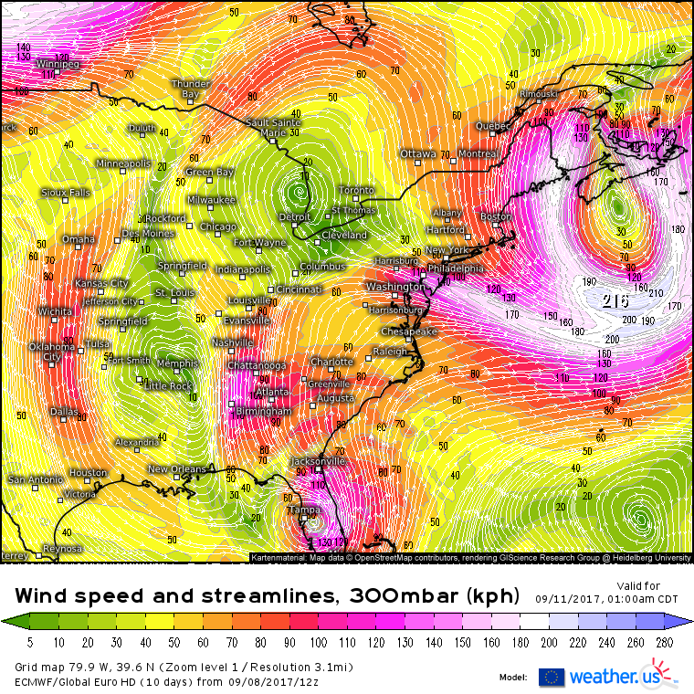
ECMWF upper level wind analysis shows a textbook Predecessor Rain Event setup with a large area of upper level divergence (winds diverging away from each other) over the southeast. Additionally, southerly winds will transport tropical moisture for Irma. This setup screams heavy rains for a large swath of the Southeast from Eastern Alabama over to the Appalachian mountains and down through the Carolinas. NE North Carolina is likely to see little in the way of rainfall, but amounts will ramp up towards Raleigh and especially towards Charlotte.
How much rain is expected?
This map from the ECMWF gives a pretty good idea of expected rainfall amounts. The highest totals will be down across Florida, but a widespread 3-6″ rainfall is expected across the interior southeast. Notice that I think rainfall amounts are underdone a little bit by the models that may not see this PRE setup very well. While 6″ of rain isn’t enough to cause the catastrophic flooding we saw in Harvey, it will certainly cause some issues for areas typically impacted by high water levels.
In addition to rain and wind, severe weather will be a threat as changing winds with height caused by the hurricane’s circulation generates rotation supportive of tornadoes.
The tornado threat will be present out in front of the core of the storm all the way from Southern Florida up through Georgia and the Carolinas.
Irma will move northwest into Tennessee by Wednesday where it will dissipate. By Friday, Irma will cease to exist and high pressure will take over, allowing for recovery and relief efforts to begin in earnest without weather-related interruption.
What about the other hurricanes in the Atlantic? I won’t go into great detail for each of these systems as they’re not forecast to imminently impact the US as Irma is. However, I’ll quickly mention both Jose and Katia as they are both strong hurricanes forecast to impact land tomorrow.
Let’s start with Jose which is a mere 5 mph weaker in winds than Irma at the moment.
The system is compact, and displays a strong core of well organized thunderstorm activity. Upper level outflow is strong in all directions, indicating a healthy system. The system looks similar to what Irma looked like as it moved through these same areas just a few days ago.
Where is Jose forecast to track?
Unfortunately, it will track very close to the Leeward Islands tomorrow. Sound familiar? The same islands expecting major hurricane impacts from Jose are the islands that took a direct hit from Category 5 Irma just a few days ago. Jose’s NW track will continue for the next few days until it hits a steering dead zone over the SW Atlantic. Where the system goes from this “dead zone” is hard to tell right now, and there’s no point speculating, though out to sea is currently the preferred option.
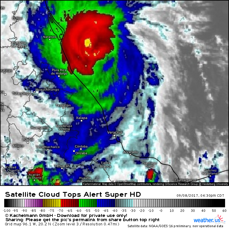
Hurricane Katia is forecast to make landfall in Mexico tonight as a Category 2 storm with 105 mph winds. Satellite imagery shows that the system is relatively compact with its impacts confined to a small area.
Katia will move inland tonight and dissipate quickly with the threat for mudslides lingering in the mountains for a few days.
I’ll have another complete analysis of Irma tomorrow morning!
Jack Sillin is a weather nerd and forecaster who regularly writes for weather.us and 33andrain.com.
