Major Hurricane Irma Set To Roar Through NE Leewards, Will Threaten Bahamas/Florida This Weekend
Hello everyone!
Irma is now solidly a major hurricane with winds over 120mph. The system continues to have a strong presence on satellite, and further intensification is expected as it approaches the Leeward Islands tomorrow.
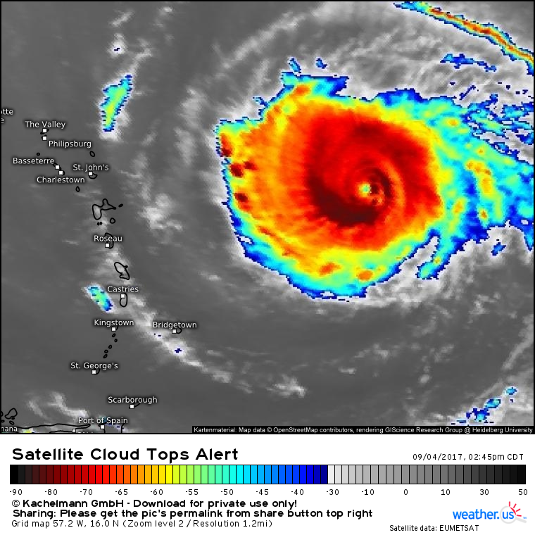
Satellite imagery of Irma shows excellent outflow, intense thunderstorms, a clearly defined eye, and spiral bands extending out from the center. All of these signals point to a very strong and healthy system that is moving west.
By tomorrow night, the storm will be approaching the northern Leewards and the eyewall is likely to impact Anguilla by Wednesday morning.
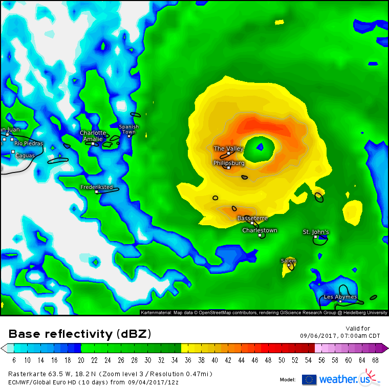
Irma’s eyewall will pack winds in excess of 130 mph as it moves through these islands. If you haven’t prepared for major hurricane impacts or evacuated from these areas, do so now. This is not a storm to take lightly!
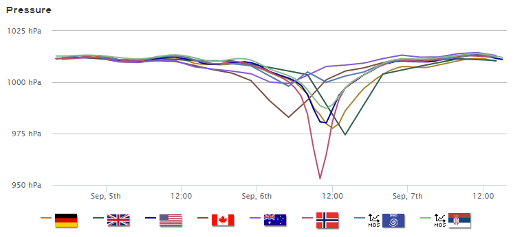
Our Forecast XL product for Anguilla shows high confidence among models that the eye of Irma will pass either directly over the island, or very close to it.
The steep drops in pressure indicate the core of Irma passing overhead Wednesday morning. The disagreement among models stems from the fact that it remains to be seen if the eye itself (the area with the lowest pressure) makes landfall, or if the island only sees the eyewall with its higher pressures, but ferocious winds. Either way, Irma will be a fairly quick mover and the storm is expected to depart by Thursday.
The environment around Irma will continue to be extremely favorable for intensification as the system moves WNW.
Dry air has been a concern for Irma in the past few days, but as it moves through and then north of the Leewards, the dry air will become washed out by the storm’s immense engine of moisture. Notice how there’s little if any dry air within hundreds of miles of the storm according to the ECMWF forecast.
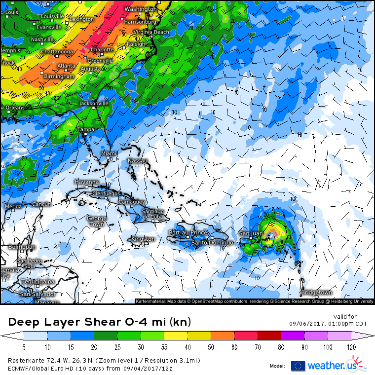
Wind shear, another common inhibitor of a hurricane’s strength, is also expected to be nonexistent.
Notice how there’s zero wind shear within hundreds of miles of Irma. A healthy hurricane will produce some shear of its own, but because that shear is just part of the circulation, it doesn’t harm the storm itself. Shear generated from sources outside the hurricane (an upper level low, for example) can rip a hurricane to shreds. Unfortunately, we don’t have any of that here with Irma and the storm is expected to continue intensifying as it moves north of Puerto Rico and Hispaniola. Irma could reach Category 5 status by the time she moves into the Bahamas later in the week.
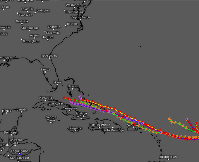
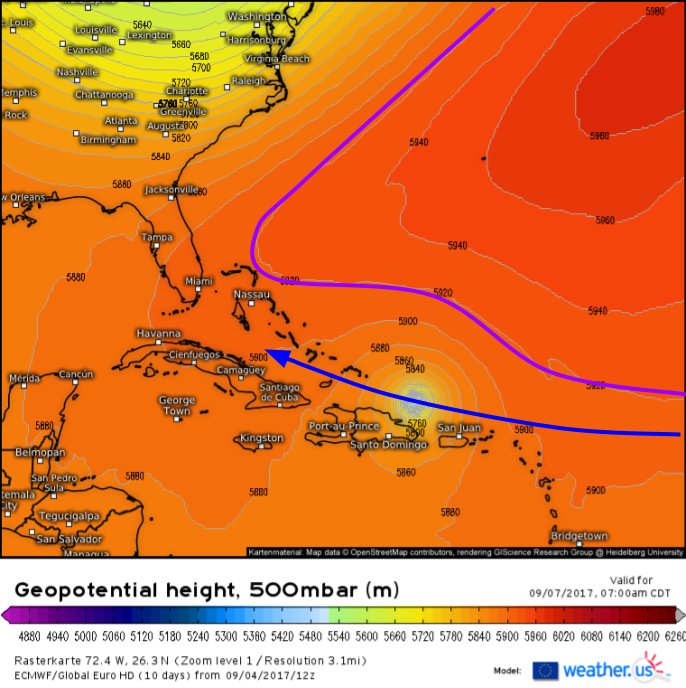
Here’s a plot of several model tracks through Friday. Notice how there’s very high confidence that after moving through the Leewards, Irma will move WNW into the Southern Bahamas. The high confidence is indicated by the fact that the models are all clustered close together. This is the high confidence part of the forecast. There is high confidence that Irma will be steered to the WNW towards the Southern Bahamas by a mid level ridge to the NE of the system.
The ECMWF shows this pattern well. Notice how the pattern here is fairly straightforward. There’s Irma, and there’s the large ridge near Bermuda. The only thing controlling Irma’s track is that ridge. Therefore, it’s easy for us to predict where Irma will go. Once we approach the weekend, however, that all changes. Things get much more complicated.
Once the storm is in/near the Bahamas, the steering flow is a lot murkier. There are two ridges instead of one. There’s a trough to the north that’s creating a weakness in the ridge and energy is diving south across the Southeast around the base of that trough. All of these players are important for Irma’s steering. Because of the weakness in the trough, and the strong high to the west, I think it’s fair to say that Irma likely isn’t a threat to the Western Gulf Coast. Because of the strong high to the east, I think it’s fair to say that Irma isn’t likely to escape out to sea. So where does that leave us? In Florida.
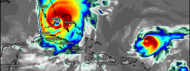
This is the ECMWF’s forecast of what the IR satellite might look like next Sunday afternoon. Notice Irma’s eye just to the East of Miami. This idea is certainly possible and is supported by other model guidance. More importantly, it fits the pattern we talked about above. The weakness between the two ridges will force Irma north. Where the turn north happens is still uncertain. The ECMWF has the turn north happen when Irma is south of Miami, hence the track very near the city. The GFS has a similar solution. Other models like the CMC, however, wait until Irma is near Key West to turn the storm north. This part of the forecast is uncertain, however it looks like Southern Florida will be close enough to the system to see some pretty significant impacts, no matter where exactly the center tracks.
What will some of those impacts be and when will they begin?
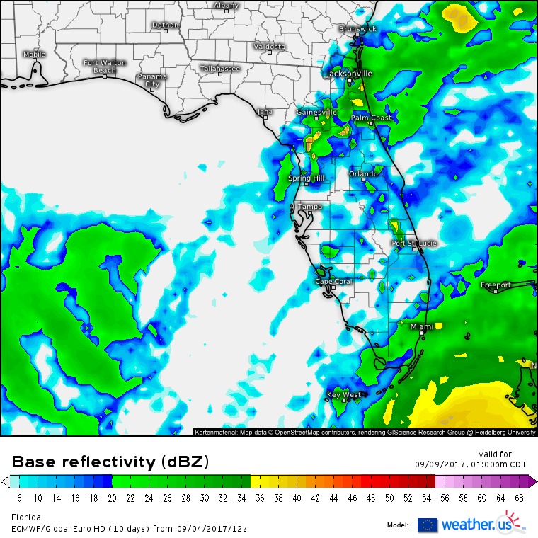
Rain bands will move into Florida Friday night and Saturday morning. Light to moderate rainfall amounts are expected in the outer bands with torrential downpours and much higher totals in the core of the system. As I mentioned before, confidence in the exact track of the core of the system is low at this point. However, confidence is high that the outer bands will impact Southern Florida beginning Saturday morning. Flooding could become a threat with torrential downpours if the core moves close to, or onto the coast, but again, there’s low confidence in that at the moment.
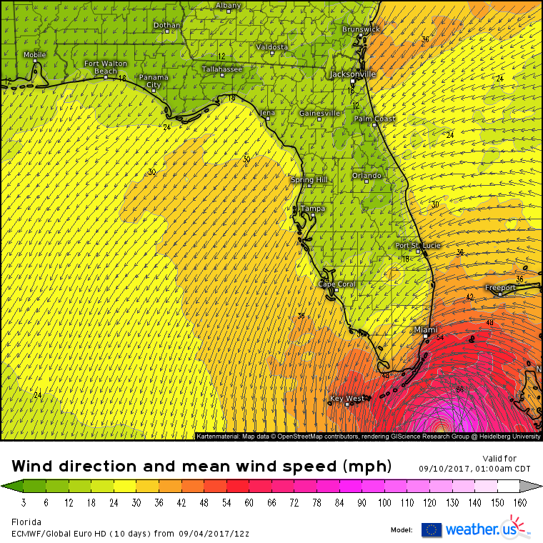
Gusty winds will begin to impact Southern Florida on Friday night. There’s currently fairly high confidence that Tropical Storm force winds will impact the southern Florida coast. The hurricane force winds will be contained in the system’s inner core and we’ve already discussed how uncertain the track of that is. However, the tropical storm force (greater than 40mph) winds will extend hundreds of miles from the center. Even if the storm moves into the eastern Gulf of Mexico (possible) or turns north slightly sooner and heads through the NE Bahamas (also possible), the Miami area is still likely to see TS force winds.
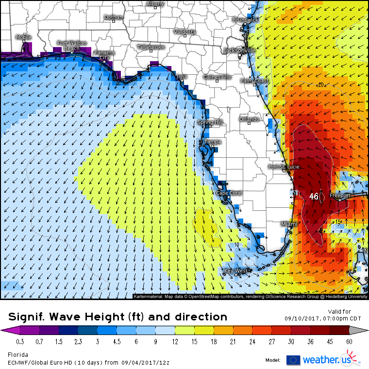
As the hurricane moves either through the Florida Straights or through the Bahamas, it will kick up some extremely large waves along the East Coast of Florida. While wave heights in excess of 40 feet shown in this model here are likely to remain offshore, breaking waves in the 20-30 foot range is not unreasonable depending on the exact track the storm takes. These waves will cause beach erosion and damage to vulnerable structures right at the water’s edge.
These three impacts (moderate rains, breezy/gusty winds, and large waves) are likely in Southern Florida despite where exactly Irma turns north. Other impacts such as flooding rains, large storm surge, and hurricane or major hurricane force winds are uncertain and will depend on the track of the center of the storm. This will become much clearer in the coming days, so stay tuned for more updates! I’ll have lots of them!
Could these lower end impacts not materialize? Where will Irma go after the South Florida area? Both of these questions can be answered using the ECMWF ensembles.
Let’s start with the first question: could Southern Florida escape with little or no impact at all? The answer is yes that’s possible, but growing increasingly unlikely. Looking at the ensemble tracks above, I count about 10 members that take the storm either too far west or too far east for South Florida to get tropical storm force winds. I count about three members with tracks that would keep the Miami area dry. Only the tracks far into the Gulf of Mexico (3) would keep the threat for beach erosion to a minimum. The EPS (Ensemble Prediction System) has 51 members, and a few simple calculations result in some pretty small probabilities for a zero impact event in each of those categories.
Now to answer the question of where Irma will head following the South Florida region. As you can see, the general trend is to the north through the weakness we discussed earlier. However you can also see that there’s a considerable amount of disagreement among ensemble members as to where the system goes. A few members (3) take Irma out to sea, east of the Outer Banks. Many favor a landfall somewhere in the Carolinas, while others move into the Gulf of Mexico. Right now, everyone from the Florida panhandle all the way up into the Mid Atlantic should be prepared for Irma to visit. In the coming days, we’ll start to nail down the track of the system and I’ll be sure to keep you updated as I know more!
-Jack





Sure is a good thing that the next system isn’t supposed to be so strong