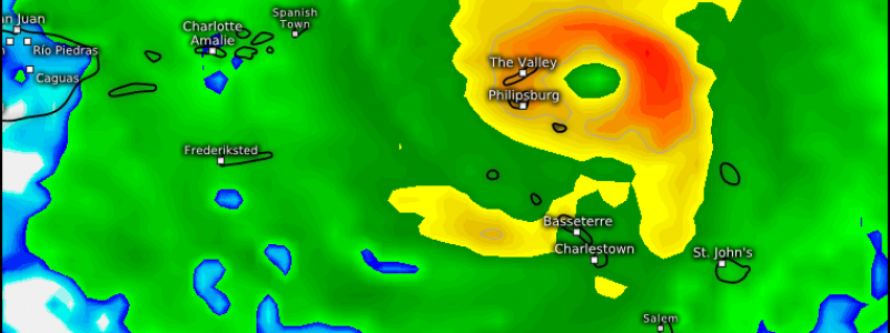
Hurricane Irma Will Bring Major Impacts To The Northeast Caribbean This Week
Hello everyone!
Just as Harvey’s remnants are finally exiting New England, closing the books on that tropical system, another is brewing in the Atlantic. The new system, named Irma, has organized much farther east than Harvey did. As a result, we have much more time to watch the system, and it also has a better chance of missing the US. However, the large scale pattern appears unfavorable for that. In this post, I’ll go over the impacts to the Caribbean and then will discuss what we know, and don’t know, about the potential for impacts here in the US.
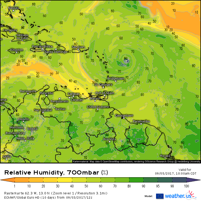
Satellite imagery from this afternoon shows that Irma is struggling a little bit today. While its outflow, spiral bands, and thunderstorm activity all look excellent, the entrainment of some drier air into the system has resulted in the eye becoming ragged and much less clearly visible today than yesterday. This could also be due to an Eyewall Replacement Cycle which occurs when a strong hurricane spins too fast for its own good, leading the innermost ring of thunderstorms to collapse. The inner eyewall is then replaced by an outer eyewall that is more stable. During EWRC’s, hurricanes often take on a more ragged appearance and can weaken as well.
Irma’s environment will improve considerably tomorrow as the system moves WSW.
Today’s dry air will be long gone tomorrow, and additionally, Irma will move over warmer waters. Because hurricanes get their energy from warm waters beneath them, the warmer the water is, the more fuel a hurricane has to strengthen. In any case, Irma will approach the Leeward Antilles Tuesday afternoon as a strong and strengthening hurricane. Any preparations on these islands should be completed tomorrow as conditions begin to deteriorate Tuesday.
While wobbles in the track of Irma’s eye will determine who, if anyone, will get the worst conditions in the islands, model guidance shows the storm at the very least making a very close pass to the islands.
This is the ECMWF, the best performing model in the world that is available for free exclusively at weather.us. It’s forecast has the eye of Irma passing directly over Antigua and Barbuda before heading WNW towards the British Virgin Islands. Again, it’s too early to predict the exact wobbles of such a strong storm, but residents of the northeast Caribbean should take Irma very seriously as she’ll approach with wind gusts approaching 150 mph.
After causing major impacts to the NE Caribbean, where will Irma go? As we head out into the day 5-7 timeframe, the forecast becomes more uncertain. There’s high confidence that Irma will end up in the SE Bahamas in about 5 days.
Past that, it’s hard to know for sure, if even at all, where the storm will track. Instead of focusing on one solution which, at this stage in the game isn’t a wise idea, I’m going to go over some of the large scale players that will impact Irma’s potential track. I’ll also go over the range of possible outcomes in terms of where the storm could go.
Let’s start with the pattern. There’s very good agreement between models on some of the large scale features that will drive Irma’s steering.
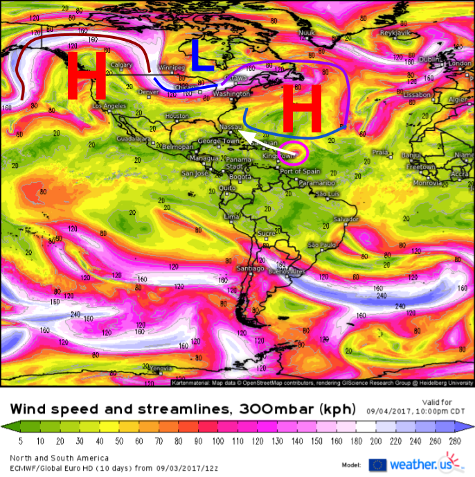
The pattern across the Northern Hemisphere is extremely volatile at the moment, due in part to Typhoon Sanvu which threw a big wrench in the circulation over the North Pacific last week. The disruption the typhoon caused is rippling downstream and is responsible for the large storm in the Gulf of Alaska as well as the large ridge currently present over the West Coast. Through a series of complex interactions, this large ridge is set to cause the development of a trough in the eastern US, which in turn will result in the strengthening of a large ridge over the Atlantic. That ridge over the Atlantic will steer Irma WNW once it finishes its current WSW jog. This is where the uncertainty begins. Once Irma moves into the Bahamas, it will interact with elements leftover from the Eastern US trough, as well as the West Atlantic Ridge (WAR for short).
Let’s break down some of those elements and their interactions a little bit.
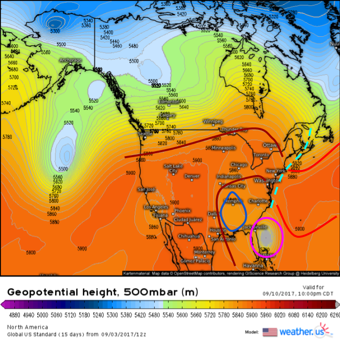
Zooming in from the Hemispheric scale, we see several key players present over North America and the adjacent Western Atlantic ocean.
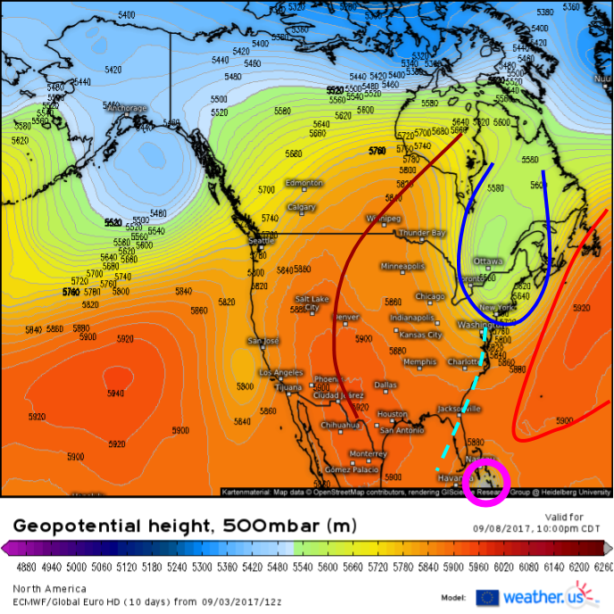
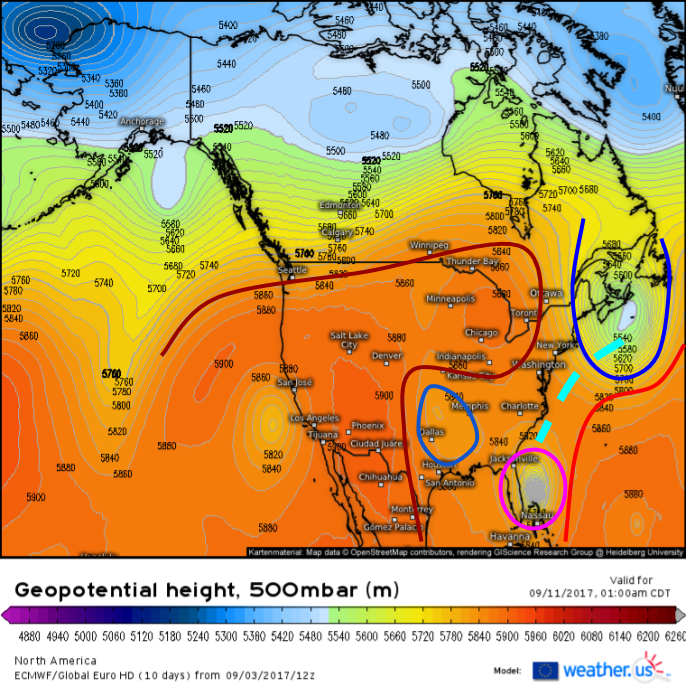
The first player to watch will be the West Atlantic Ridge (WAR) which is marked in bright red. This will steer Irma (pink) WNW towards the Bahamas. A trough will develop in the Northeast US (deep blue) and it will force southward some energy (light blue) that will break the link between the WAR and another ridge, centered over the western Plains (dark red). This will allow Irma to turn north at some point. How far west Irma is when this turn north occurs will determine where the storm will eventually track. This is where the uncertainty comes in. Subtle differences in how the models handle these features results in very large differences in how they portray the eventual outcome of the storm.
The first model we’ll look at is the ECMWF.
The ECMWF keeps the northeast US trough very strong all the way through next weekend. It never allows the WAR to dominate the Western Atlantic, steering Irma west. The ECMWF has a very strong connection form between Irma and the NE trough. This connection allows the trough to pick Irma up and sling it out to sea as the Central US ridge builds in. A an upper level low (ULL) over the lower Mississippi valley will try to pull Irma NW closer to the coast, but with such a strong trough near Nova Scotia, it won’t have much influence.
The GFS, on the other hand, paints a much different picture.
The GFS has a strong WAR that almost completely reattaches itself to the ridge over the Central US. The NE US trough is long gone and only a very weak gap is present between the two ridges. As a result, the ULL near Memphis can pull Irma northwest into the coast.
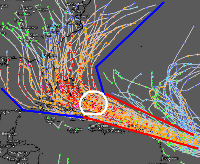
So which solution is more likely? At the moment, that’s hard to say. One tool that forecasters like me use to evaluate how much uncertainty is present is known as ensembles. Ensembles are produced when the same model is run over and over again with very slightly different initial conditions. This produces a wide range of possible outcomes. If all the ensembles agree, the forecast is high confidence. If the ensembles disagree, the forecast is low confidence. What do the ensembles say about Irma?
This is the output from the ECMWF’s ensembles. Notice how they’re tightly clustered with a WNW track (red lines) until Irma gets to the SE Bahamas in about 5 days (white circle). After that, all bets are off track wise. Some members show the storm moving into the Gulf of Mexico, some show the storm hooking into the Southeast coast, and some show the storm barely escaping out to sea. Until those ensembles agree more, it would be irresponsible for me to speculate on where Irma will go past the Bahamas.
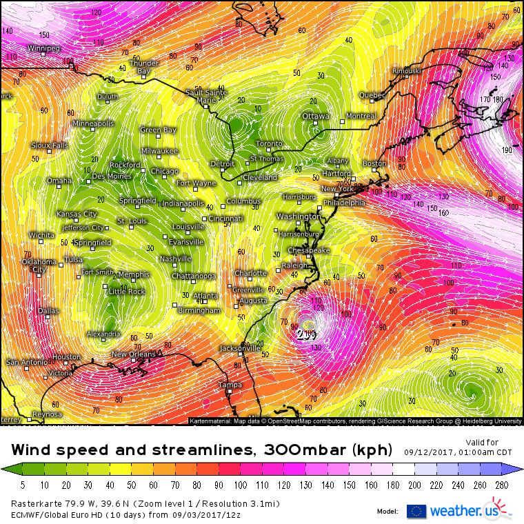
Still unsure about where the uncertainty comes from?
Each and every swirl here is a feature that could steer Irma one way or another. Expecting models to accurately and precisely forecast each and every one of these features is asking far too much. It’s always important to remember that in a chaotic, non-linear system, predicting the future is a remarkable challenge.
That’s why I’ve done what I’ve done here. I’ve outlined the pattern, given you a range of possible outcomes and how they could come to fruition, and I’ve explained not only what I know, but what I don’t know.
I know that Irma will be a strong and very dangerous hurricane as it moves close to or through the Leeward Islands. I know that after the Leeward islands, the storm will track WNW towards the Southeast Bahamas, likely as a very strong system. I don’t know where the storm will go from there. I don’t know when or where the storm will make landfall, if it even does at all. Anyone who tells you that they do know where Irma’s headed or where it will make landfall is trying to fool you. We’ll be able to start honing in on potential landfall locations tomorrow, and by midweek we should have a pretty good idea where Irma’s headed.
Regardless, it’s never too early to be prepared for a hurricane. If you live anywhere along the East Coast from Florida to Maine, I’d recommend throwing in some extra non-perishable foods, bottled water, and batteries into your shopping cart early this week. Those are essential items to have if a hurricane makes landfall, and if the forecast begins to zero in on your area, every one of your neighbors will be looking for those same goods. If you get prepared now, and the storm misses, you can breathe a sigh of relief knowing you’re better prepared for the next one. If you’re not prepared, and the storm hits, you’ll be left joining a mad dash for supplies that are likely to run out in the days and hours before the storm arrives. Better to be safe than sorry!
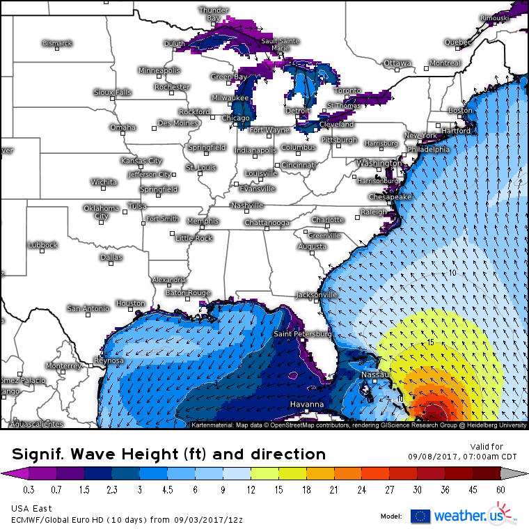
There is one impact that will be felt down the length of the East Coast, no matter where Irma tracks, and that is large swells. Swells will arrive on Tuesday and will build steadily through the week. Exactly how big those swells get will depend on the exact track of the storms, but everyone from Maine to Miami will see breaking waves big enough to cause a rip current threat. Avoid going in the water and if you do, use extreme caution! Parts of the Atlantic coast of Florida could see waves big enough to cause serious problems such as beach erosion if the storm tracks close enough.
I’ll have much more information in the days to come as Irma slowly but steadily makes her way closer to the US. My next update here will be tomorrow morning when I’ll have a brief summary of the weather across the country.
Follow weather.us on Twitter for more frequent updates during the day tomorrow.
-Jack

