TD Harvey Continues To Organize This Evening
Hello everyone!
Here’s a quick update on Harvey this evening as it continues to develop. The Hurricane Hunters have been flying through Harvey over the past couple of hours and they’ve found that the storm has not strengthened into a tropical storm yet. This means that the winds are still below 40 mph. Despite this, GOES-16 satellite imagery clearly shows an organizing system. Harvey is expected to strengthen into a tropical storm tonight.
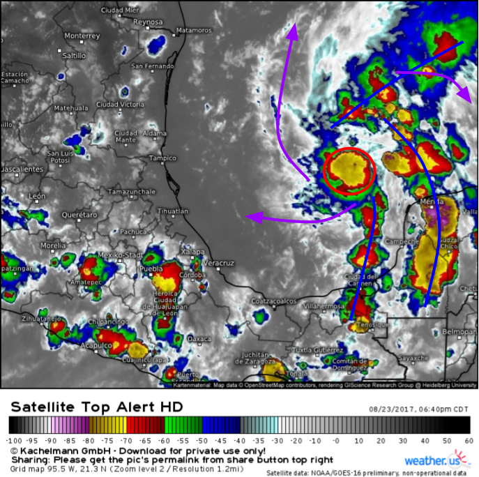
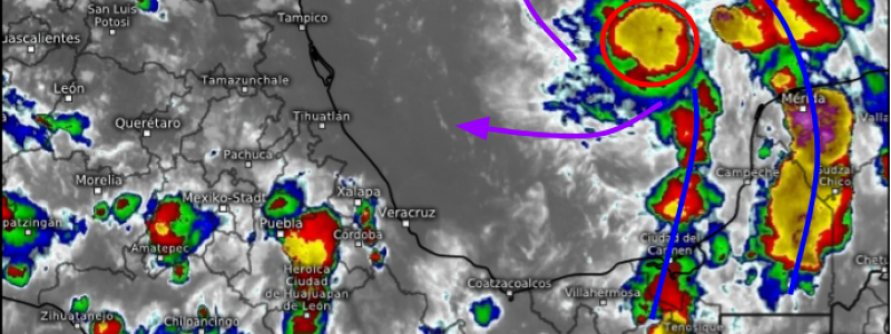
Here’s the latest GOES-16 image of the storm. Because the sun has now set over Harvey, we need to use satellite images that don’t require light from the sun. IR imagery, which works by detecting the amount of heat in the atmosphere, works quite well overnight. All of the same structures we’ve been talking about are noted this evening. A cluster of strong storms has formed over the center of Harvey (red circle) and outer bands of thunderstorms are beginning to form surrounding the system (blue lines). Meanwhile in the upper levels, cirrus clouds continue to fan away from the storm which confirms the presence of an upper level high pressure located overhead.
I went into great detail about how the upper level high pressure would help Harvey in my blog post from this afternoon. I also talked about the timing of the system and some of the impacts. I want to go through a quick summary of each of the main impacts from the system here in case you don’t have time to read through the entire post from earlier.
Flooding
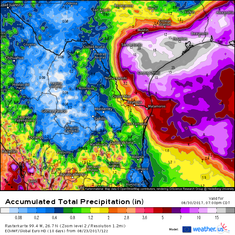
The main threat from Harvey will be inland flooding as the system stalls over Texas (I discussed the mechanics behind the stall earlier this afternoon). Rainfall amounts in excess of a foot are expected across a wide swath of SE Texas with some isolated amounts potentially reaching the 2 foot mark or even higher. Here’s the 12Z ECMWF’s total rainfall forecast.
Any time rain totals are measured in feet, it’s time to take the flooding threat very seriously. Rainfall will begin over SE Texas Friday morning and likely will continue until Monday or Tuesday when the system gets kicked back east towards Louisiana. If you live anywhere in SE Texas, now is the time to prepare for potentially devastating flooding!
Storm Surge/Coastal Impacts
Harvey will approach the Texas coast as a strong tropical storm or weak hurricane, and it will linger over the same locations for several days. This means that winds will be pushing water onshore for days on end across parts of the Texas Gulf Coast. The result? Storm surge and coastal erosion/flooding will be big concerns this weekend.
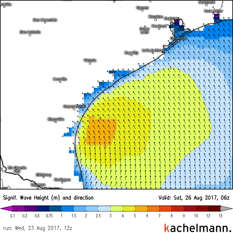
This is the ECMWF’s wave model and it shows waves in excess of 5 meters (16 feet) near the Texas Gulf Coast on Friday night as Harvey moves ashore. These waves will pound coastal dunes and unprotected structures. In addition, a storm surge of several feet is expected which will cause significant flooding in low lying coastal areas. If your area is susceptible to coastal flooding, take action now to prepare for Harvey’s surge!
Storm surge/coastal impacts will subside Monday and Tuesday as the storm moves east and winds turn offshore.
Winds
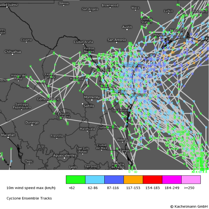
Harvey is currently forecast to make landfall as a strong tropical storm or weak hurricane. However, conditions are favorable for rapid intensification if the system can get its act together. A “spaghetti” plot of all the potential tracks of Harvey forecast by the ECMWF ensembles shows that there is still considerable uncertainty as to where exactly the core will move ashore.
Where exactly the core of the system moves inland will determine who gets the worst of the winds. Anyone along the Texas coast from Brownsville to Houston should be prepared for hurricane force winds. Not everyone will get those winds, but due to sensitive steering patterns in the upper levels, it’s impossible to pin down exactly where the storm will come ashore. While current forecasts only call for low-end Category 1 winds, as mentioned earlier, there is the potential for rapid intensification of the storm. If the system came ashore with Category 2 (~100mph) winds, I wouldn’t be surprised. It’s always better to be over prepared than under prepared!
While hurricane force winds will cause damage where they come ashore, do remember that the primary threat with this system is not the winds, it’s the flooding!
I’ll have another update tomorrow morning that discusses any changes to the forecast brought on by overnight model guidance (including the ECMWF) as well as overnight satellite trends. In the meantime, you can access all the data yourself at weather.us! Click the links above to monitor the storm 24/7! Some things I’ll be looking for in the satellite imagery will include the continued organization of thunderstorms into banded structures, the continued development of deep convection (thunderstorm activity) over the center of the storm, and increasing thunderstorm intensity/coverage overall. You can look for these features too!
-Jack Sillin
