Harvey Set To Bring Dangerous Flooding To Texas This Weekend
Hello everyone!
Harvey has officially regenerated into a Tropical Depression as of 10 AM CDT. It’s expected to strengthen into a tropical storm as it moves north towards the Texas coast. It could even become a hurricane before it makes landfall this weekend. Below is a full breakdown of expected impacts, timing, and of course some of the factors going on under the hood that will drive the forecast for Harvey.
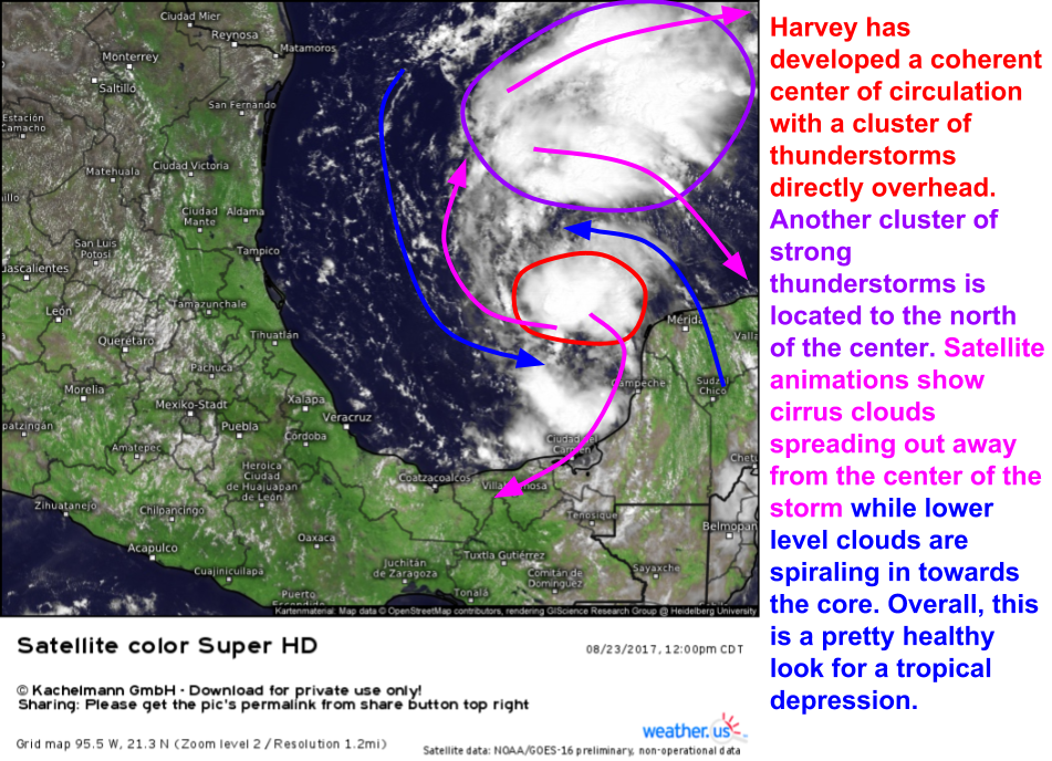
GOES-16 satellite imagery is showing a fairly healthy system considering how disorganized it looked yesterday. Clusters of strong thunderstorms are noted both over and to the north of the center. Most importantly, satellite animations show cirrus clouds spreading out clockwise away from the center of the storm. This helps to vent the air from the top of the system out away so that it can sink away from the center of the storm. Remember that sinking air suppresses thunderstorm development; if air rapidly rising in the center of the storm had nowhere to go but straight back down, the tropical system wouldn’t have long to live. With an upper level anticyclone venting the system, air can continue to rapidly rise in the center of the storm, where it can be quickly whisked away when it reaches the stratosphere. The bottom line? With an upper level anticyclone overhead, Harvey is likely to have no trouble quickly organizing and intensifying as it moves north tonight and tomorrow.
So where’s Harvey headed?
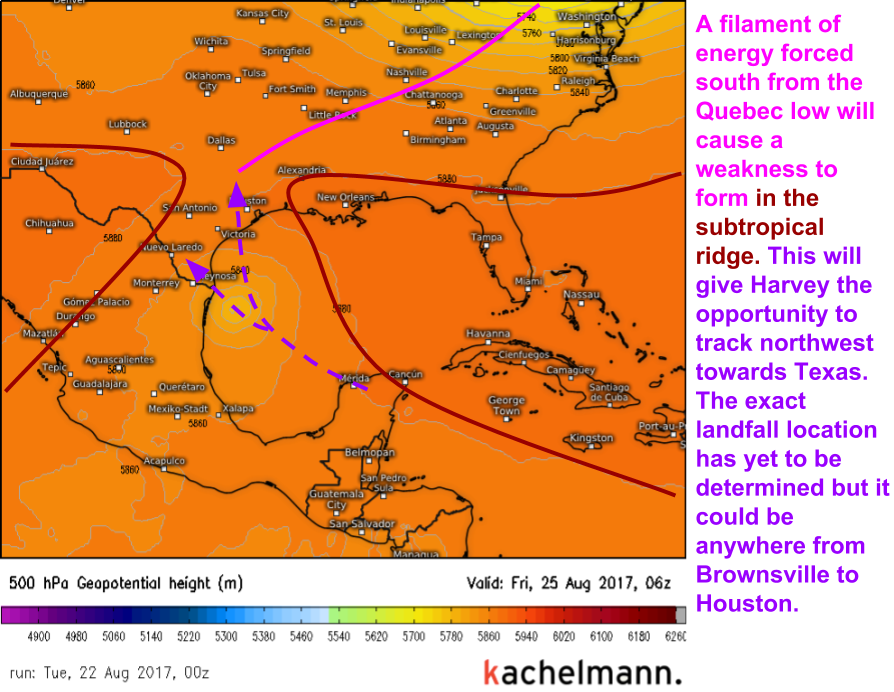
The strong low pressure system moving through Quebec today will play an important part in Harvey’s future. It will drive southward some upper level energy, which will play an important part in where Harvey will track. How will this happen? The upper level energy from the Quebec storm will cause a weakness to form in the strong subtropical ridge that usually keeps tropical systems on a westerly track into Central America. Those storms would love to move north, but are blocked by the ridge. Harvey, however, won’t have that problem thanks to that weakness. Therefore, it will track NW as opposed to W. This means Harvey is headed straight to the Lone Star State.
The biggest impact from Harvey, far and away, will be torrential rains. There will be some wind/surge damage along the coast, but torrential, flooding rains will spread hundreds of miles inland as the storm stalls. It’s hard for me to overstate how bad the flooding could get for some parts of southeast Texas. While there’s still some uncertainty as to exactly which areas see the worst flooding, model guidance is fairly confident that there’s the potential for 1-2 feet of rain across parts of SE Texas. Some places could exceed 2 feet of rain depending on exactly how long the storm stalls out for.
This is a snapshot of our Forecast XL product for Houston Texas. Notice how almost all the available computer model guidance (ignore the crazy outliers, such as the 35″ forecast and the 1″ forecast) suggests between 1 and 2 feet of rain will fall over the coming week, and there’s some support for amounts over 30″. This is an incredible amount of rain! So why will it rain so much?
The answer to this question boils down to two main things. First, tropical storms have LOTS of moisture associated with them, and second, this tropical storm is expected to hit the breaks once it moves ashore in Texas. This means that the torrential rains from Harvey will fall over the same places over and over and over again.
This map is of the “Precipitable Water” forecast by the ECMWF model as Harvey is making landfall Friday night. Precipitable water (PWAT for short) is a measure of the total amount of moisture in the atmosphere. It’s arrived at by “pausing” the atmosphere and condensing all the water in it at a given point. Note that rainfall totals can be much lower than the PWAT values if not all the moisture in the atmosphere is condensed into rain. Alternately, if moisture is continuously transported into an area as it’s raining to replentish the atmosphere’s supply of precipitable water, total rainfall can be much higher than the PWAT value. The bottom line is that we can use PWAT forecasts to help get a sense of how much moisture is present in the atmosphere, and there’s going to be a LOT of moisture in the atmosphere over Texas as Harvey moves ashore.
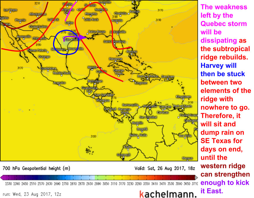
So why is Harvey going to stall? It will be the unfortunate pawn in a tug-of-war between two pieces of the subtropical ridge.
The Quebec storm that we discussed yesterday (the one that brought the cool, dry weather to the northeast) has cut a hole in the subtropical ridge. This is allowing Harvey to move north towards Texas. Once it makes landfall, that hole will be closed as the subtropical ridge rebuilds. One part of the ridge will be located over Florida and the Eastern Gulf of Mexico while the other part will be located over the Desert Southwest. The tug of war between the two highs will mean that Harvey will stall out over SE Texas for several days, dumping heavy rains continuously over the same areas. Eventually, the high over the Desert Southwest will strengthen and kick Harvey slowly east, potentially back into the Gulf of Mexico where it could restrengthen before setting its sights on Louisiana. That part of the forecast is quite uncertain at this point, however as any restrengthening wouldn’t be for another 6-7 days.
So what’s the timeline for all of this?
Tomorrow looks like a typical summer day across Texas. Use tomorrow to prepare for Harvey. Execute your tropical storm preparedness plan if you live along the Gulf Coast, especially if you live in the Brownsville/Corpus Christi area. The trend today has been for landfall to be slightly farther to the west as the eastern high over Florida looks to temporarily become stronger than the high over the Desert Southwest. Pay attention to local media and heed the instructions of local officials. Evacuate if you’re told to! Very subtle shifts in the strength of our two highs could mean wide swings in the potential landfall locations anywhere from Brownsville to Houston could see Harvey’s core come ashore.
By Friday morning, Harvey’s outer rain bands will be moving ashore in SE TX. Winds will begin to pick up as well, especially in the areas where the core of the storm is headed. All your preparedness actions should be complete by Friday morning. Assemble food, water, fuel, cash, and medical supplies tomorrow. Don’t wait until the rain and wind begin!
Harvey’s center will make landfall Friday evening, somewhere between Brownsville and Houston. Due to the sensitive nature of the steering environment, very subtle changes in the atmosphere anywhere across the entire southern half of the US could have ramifications for where Harvey actually hits. Regardless, heavy rains will sweep ashore across southeast Texas and parts of the Gulf Coast will see high winds and storm surge.
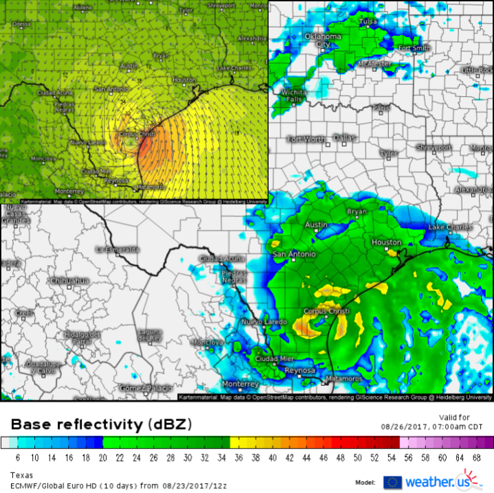
Harvey will slowly move north Friday night and heavy rains/high winds will continue into Saturday. On Saturday morning, the Gulf Coast will continue to experience storm surge and high winds while heavy rains will continue to spread inland reaching Austin and San Antonio. This is a good time to remind everyone that tropical systems are not points on a map. Their impacts spread hundreds of miles from the center of the storm and Harvey will be no exception. The greatest threat from Harvey will be inland flooding which will occur as the storm dumps feet of rain well inland from wherever it makes landfall. Even if you’re not in the “cone of uncertainty” put out by the NHC or if you live hundreds of miles from the nearest Gulf Coast beach, you still could see extremely dangerous flooding!
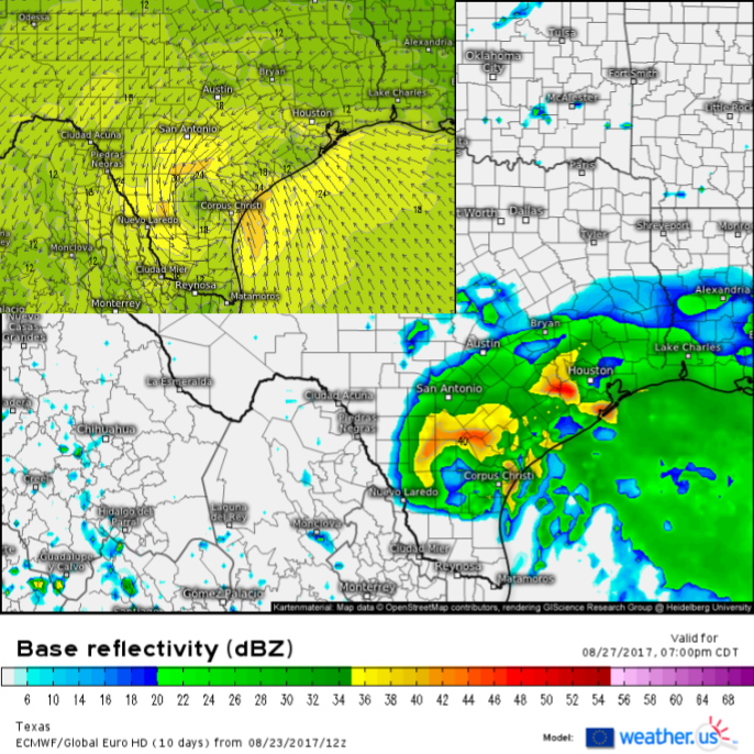
By Sunday evening, the situation will not have changed much over SE Texas. This is what will make Harvey such a prolific rainfall producer. Notice that the same areas forecast to get torrential rains on Saturday morning are still getting poured on by Sunday evening. High winds along the Gulf Coast will slowly subside as the system weakens over land, but the flooding threat will only be getting worse. It likely won’t be until some time on Monday or Tuesday that the storm finally kicks East back out over the Gulf of Mexico.
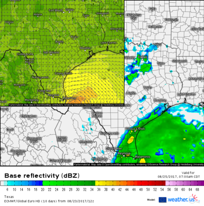
All of the images I’ve used to outline the timing are available for you to see on weather.us! Check out the ECMWF simulated radar, and the forecast wind speed, and use the menus to the left of the image to adjust the parameter, time, and zoom of the map.
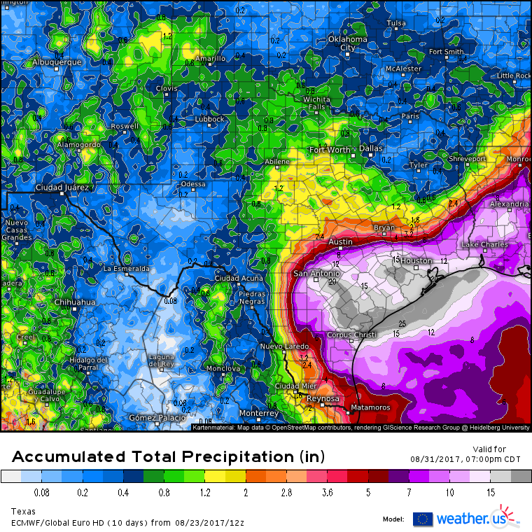
Current model indications are that one to two feet of rain will fall over a “jackpot” area from Corpus Christi to San Antonio to Houston. This is clearly seen above. While other areas outside this region will see hefty rainfall totals, it’s this area where potentially catastrophic flooding will occur. It’s hard to overstate the impact that two feet of rain will have on these areas.
As Harvey bears down on Texas, weather.us will be your one stop shop for information about the storm. Here are a few links to bookmark so that you can follow the storm’s every move.
Gulf of Mexico GOES-16 visible satellite – you can click the image to zoom in, and you can use the menus to the left of the image to adjust the satellite view. Note that the visible satellite won’t be available at night so you’ll have to use one of the day/night options.
ECMWF Model forecast maps – change parameters, zoom in, and adjust the time using the menus to the left of the image.
Corpus Christi HD radar imagery
Forecast XL for Houston – enter your town name to get specific information for your location
I’ll have another quick update tomorrow morning if anything substantial changes!
-Jack Sillin
