Cooler Weather Set To Arrive Over The Eastern US This Week
Hello everyone!
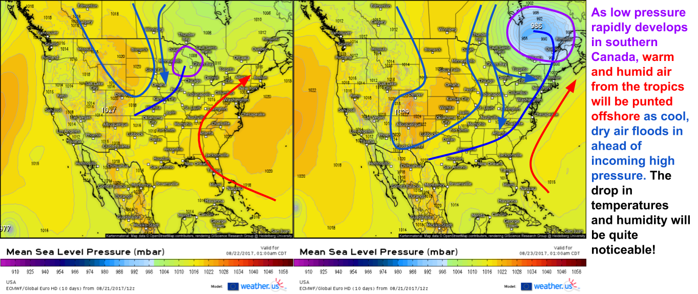
With the eclipse now behind us, it’s time to look ahead to the upcoming week of weather. The main weather feature in North America will actually develop over southern Canada, but nevertheless will impact much of the US east of the Mississippi.
That feature in Southern Canada will be a rapidly intensifying low pressure system. Its pressure will drop 22mb in 24 hours according to ECMWF data, putting it nearly in the category of rapid intensification known as ‘bombogenesis’, where a storm’s central pressure deepens (lowers) 24mb in 24hrs or less. These rapidly intensifying cyclones can bring a variety of harsh weather conditions, especially in the wintertime. For this go around, severe weather and a respite from the heat will be the two main side effects across the northeastern quadrant of the US. The southeast may see the front help to facilitate tropical development, depending on how things shake out. More on that below.
Before we can enjoy the beautiful cool breezes that will sweep through behind the front, we need to worry about a little bit of severe weather. As I’ve discussed frequently before, both here and on twitter, there are three main things you need for organized severe weather: Instability, Shear, Trigger. Let’s run down the list for tomorrow as our cold front works east.
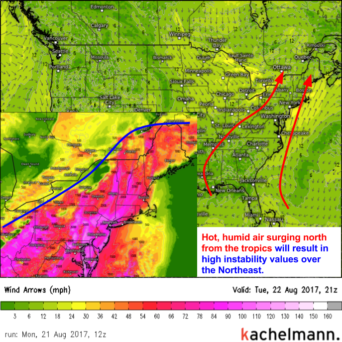
High pressure will be located near Bermuda tomorrow and clockwise flow around it will result in the northward transport of hot, humid air. Temperatures will climb above 90 across much of the East Coast tomorrow. While hot, humid air is terrible for working out or enjoying time outdoors, it’s great for fueling thunderstorms because it’s extremely unstable. Instability is one of the 3 ingredients needed for severe thunderstorms, and it won’t be lacking across the northeast tomorrow.
The second important ingredient is shear. A strong upper level disturbance will be rotating through the Great Lakes tomorrow. Out ahead of it, strong southwesterly winds aloft will sit atop much weaker southerly flow at the surface. This change in wind speed and direction with height is known as wind shear. Shear is the second main ingredient you need for severe storms, and it too will be found in abundance across the Northeast tomorrow.
The final ingredient is the trigger, and we’ve already talked about a frontal boundary moving through the region. The incoming cold front will help to touch off severe thunderstorm development tomorrow across the Ohio Valley and storms will quickly move into the Northeast. Damaging winds will be the main threat from tomorrow’s storms, which will be strongest across inland areas. By the time the storms reach the coast, the sun will have set well below the horizon and temps will be cooling, thus limiting the instability. Without instability, the storms will simply run out of gas and die off as they approach the coast early Wednesday morning. The front will sweep through before daytime heating can really get going on Wednesday, thus securing a storm free day for the coast.
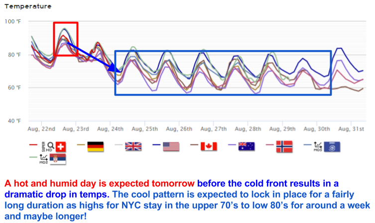
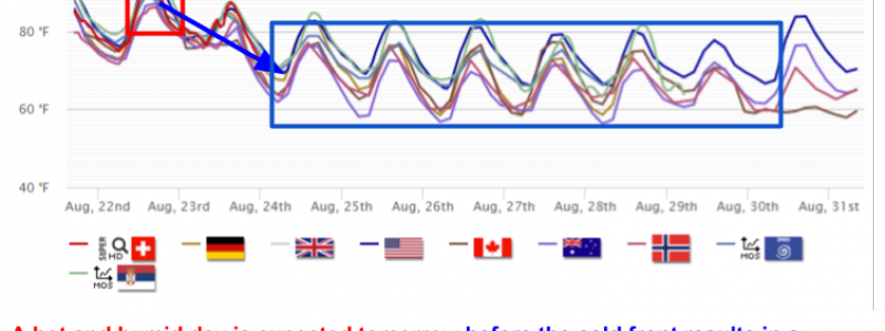
The effects of the cold front are clearly seen in our Forecast XL product for NYC. After one more day in the upper 80’s to low 90’s, the cold front will sweep through on Wednesday morning resulting in a much more comfortable pattern through the rest of the week and into the upcoming weekend. The same thing will be true all across the northeast as Canadian air rushes in on NW breezes.
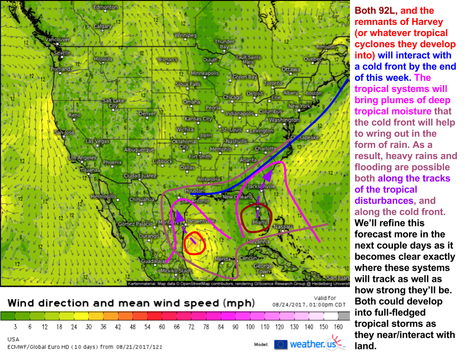
What about the rest of the country? The impacts of our cold front won’t stop in the northeast. The front is expected to sag south towards the Gulf Coast by Thursday where it will stall out. Remember the last time we had a cold front stall out along the Gulf Coast? Tropical Storm Emily formed from a setup not unlike this. We’ll be keeping a very close eye on the tropics as the remnants of TS Harvey move into the Gulf of Mexico near this front. It’s too early to pin down any specifics, but heavy rain could be a big issue across parts of Texas if current model guidance is any indication.
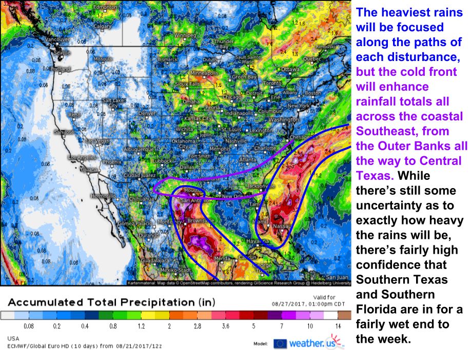
Both Harvey and 92L will be factors in the Gulf Coast’s weather by the end of this week. Both could develop into full-fledged tropical storms before they make landfall. While redevelopment into formal tropical systems is still in question, more so for 92L than for Harvey, the threat of heavy rain is fairly certain. This is especially the case given the presence of a cold front that will drop into the region behind the low pressure system we talked about above. The cold front will help provide additional lift to wring out some of the deep, tropical moisture brought into the region by 92L and Harvey. While a landfalling hurricane is currently not in the forecast, torrential rains could cause no shortage of problems especially across parts of Texas and Florida where the disturbances themselves will track.
Here’s the European model’s idea of how much rain will fall in the next 6 days. Don’t take it too literally, there’s still some uncertainty as to exactly how much rain will fall, but it does do a good job of showing us where the general bullseye regions will be- Southern Texas and Southern Florida. If you live in those areas, it’s a good idea to start thinking about the prospect for some excess water.
How about the rest of the country? The West Coast will remain seasonably tranquil as high pressure continues to dominate the region. The Southwest monsoon will continue on in its seasonably expected fashion. Up in the northern Plains, more severe weather is possible as another low pressure system develops in the lee of the Rockies. the specifics on that will continue to be nailed down in the coming days. If you’re looking for more details regarding the forecast for your location, you can always find information specific to your town at weather.us.
-Jack Sillin
