TD8 Recurves East Of The US, 91L May Pose A Larger Threat Long Term
Hello everyone!
We’re rapidly approaching the climatological peak of hurricane season and we’re starting to see signs of life in the Atlantic. Last time we talked tropics, Invest 99L was a wave out in the middle of the Atlantic and Invest 90L was drifting through the Caribbean. Since then, 90L developed into Hurricane Franklin which made landfall in Mexico several days ago. 99L has developed into Tropical Depression 8 which should strengthen into TS Gert this afternoon.

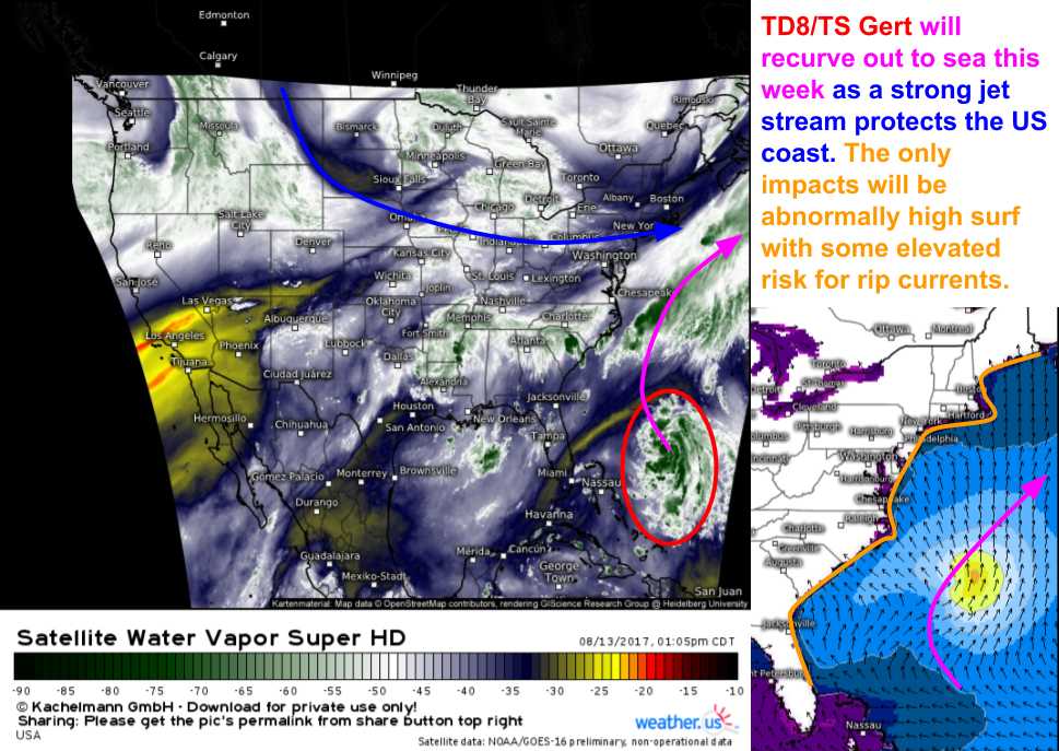
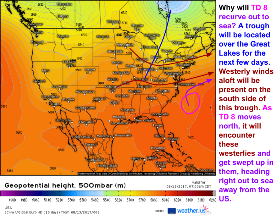
TD8, which will likely strengthen into TS Gert this afternoon or evening, will recurve harmlessly out to sea this week. The only impacts expected in the US will be in the form of swells that the storm will generate while at sea. So why is the storm recurving away from the coast as opposed to heading towards Florida or North Carolina?
The answer lies in a trough associated with the jet stream over North America. A trough is a dip in the jet stream, which blows from west to east around the Northern Hemisphere. There will be a trough over the Great Lakes this week which will push the jet stream a little bit south. As a result the jet stream’s westerly winds will be able to pick up TD8 and slingshot it out into the North Atlantic where it will eventually be absorbed by an extratropical system by next weekend.
As one tropical system zooms out of sight and out of mind this week, another will be brewing deep in the tropical Atlantic.
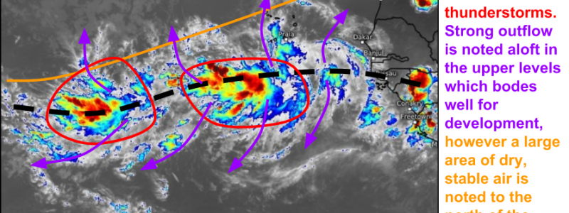
This is the next system to watch over the next couple of days, currently dubbed Invest 91L by the NHC. The “Invest” designation is given to systems that haven’t developed yet, but could in the future. Some things to note about the current state of the system include its broad and spread out nature, it’s disorganized thunderstorm activity, its solid outflow channels both to the north and to the south, and the dry air lurking just to the north. I always like to start my forecasts with observations before I go to the models, so that’s why I’ve started with the current satellite imagery for the system. What clues lurk in the satellite image with regards to the future of the system?
The broad, spread out structure of the system tells me that any development will be slow to occur. Large and broad systems need to “convince” many more factions of thunderstorms to unite under the same roof. This takes time. The presence of two distinct clusters of thunderstorms tells me to watch for a split in the system, where we end up getting two disturbances as opposed to one. The presence of strong outflow channels tells me that the system isn’t being hampered by wind shear at the moment. This will help the thunderstorms organize and develop. Finally, the presence of dry air so close to the system tells me that the storm will face at least one prominent obstacle when trying to develop this week.
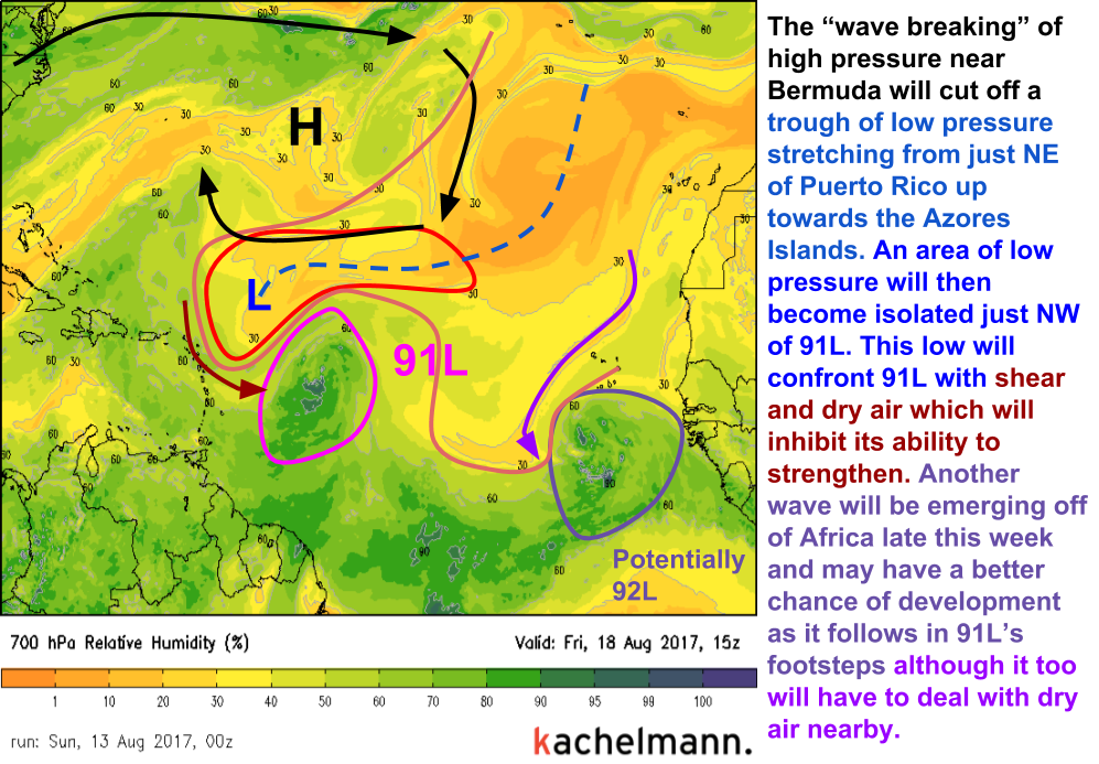
While many models are bullish on development chances for 91L, I remain skeptical. This is in part due to the dry air north of the system I mentioned earlier, and it is in part due to a phenomenon known as “Anticyclonic Wave Breaking”. This happens when an atmospheric wave breaks over itself, just like an ocean wave breaking on the beach. In this case, the wave is made up of higher pressure and warmer air. It’s breaking will isolate a pocket of lower pressure and cooler air that will occupy the space just NW of 91L or whatever tropical cyclone it happens to be at the time (it would be TD8 and if it earns a name, TS Harvey). This low pressure system will begin to generate wind shear which will force dry air towards/into 91L. This means its chances for development will be hampered a bit as it approaches the Windward Islands. If the system can develop a reasonably well defined structure before it interacts with the upper level low, it may be able to fend off the shear and dry air. If not, development will be put on hold for a few days until the ULL spins out.
So where will 91L and any potential future tropical systems track? For that we turn to the large scale pattern across the whole Hemisphere.
So why are stronger storms more likely to break through the ridge as opposed to weaker storms? All tropical cyclones “want” to move towards the poles. However, a subtropical ridge often stands in the way. These ridges extend all the way from the surface to the top of the troposphere, but often they weaken as you go up in height. As a tropical storm strengthens, it extends further up into the atmosphere where it can take advantages of high level weaknesses in the subtropical ridge. Weaker storms don’t extend very far up into the atmosphere and thus tend to track on a more westerly course, under the influence of the strong low level subtropical ridge. Where 91L and any storms that follow it will track depends largely on their strength. We’ll be watching closely to see if any threaten the US, I’ll be sure to let you know if one does!
In the meantime, continue to monitor 91L with our high resolution satellite imagery. I’ll be watching to see if the system can consolidate, if it can begin spinning, and if the two thunderstorm clusters will split apart. You can watch for all of these things too, even when I’m not posting!
Also be sure to follow our twitter account @WeatherdotUS where I post forecasts and analysis of various weather events throughout the day.
As always, more information on the forecast specifically for your location can be found over at weather.us.
-Jack Sillin


