Active Tropical Pattern Setting Up
Hello everyone!
It’s that time of year again, summer is beginning to slowly wind down and fall-like storm systems are beginning to develop up here in the US. Down to our south, though, the arrival of August means the beginning of the peak hurricane season. While the Atlantic hurricane season technically began on June 1st, there’s typically little to no hurricane activity until we get to August. Why is that? There are a number of factors that go into determining hurricane climatology but the most important factors are cooler waters (hurricanes need warm waters to form), higher wind shear (hurricanes don’t like wind shear), and lots of dry air from the Sahara (dry air shuts down thunderstorms, therefore preventing hurricane formation). By the time we get to August, those inhibiting factors begin to relax, allowing for an uptick in activity. This is shown well with a plot of hurricane activity over the course of the season from the National Hurricane Center.
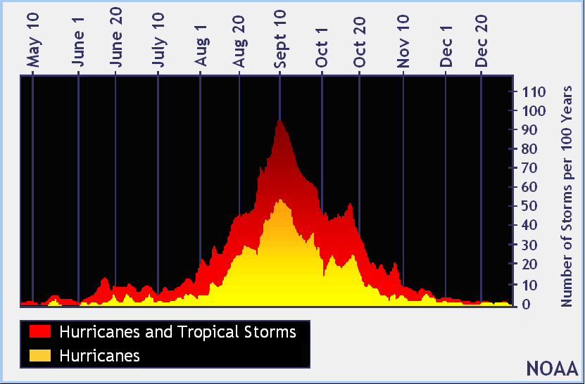
Notice how there are relatively few hurricanes in June and July, but a rapid ramp up typically begins in August. We’re starting to see this ramp up begin for the year this week with several disturbances to watch in the coming days. The first and perhaps most important disturbance has just moved off the coast of Africa. The system is currently fairly disorganized but a couple of pattern scale phenomenon make this storm one to watch closely in the coming days. I’ll go over the large scale features first, then I’ll dive into the two specific disturbances to watch.
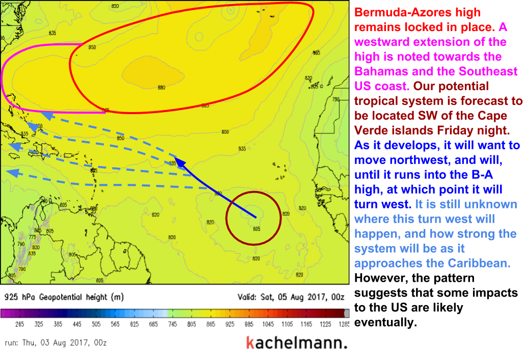
The most important large scale feature is the steering pattern. It’s set up so that any storms that form in the so-called Main Development Region (the tropical Atlantic between Africa and the Antilles islands) will move towards the US. This is due to a strong Bermuda-Azores high pressure system that will act as a “lid” of sorts keeping tropical systems that would otherwise recurve out to sea on a westward course towards land.
Of course, the steering pattern means nothing if there’s nothing to steer towards the US. There’s another large scale pattern that will help assist tropical waves in developing into tropical storms and potentially hurricanes.
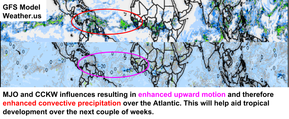
A combination of two atmospheric phenomenon, a change in the Madden Julian Oscillation and a Convectively Coupled Kelvin Wave, is resulting in enhanced upward motion over the tropical Atlantic currently. The enhanced upward motion is helping to boost convection (thunderstorm activity). Because tropical storms and hurricanes form from clusters of thunderstorms, having extra storms around is helpful for tropical waves trying to develop into stronger tropical systems.
So we have enhanced thunderstorm activity that will be beneficial to tropical waves trying to develop into tropical storms, and we have a pattern that would favor steering those tropical systems towards the US. It’s not hard to see why there’s some concern about this setup. However, even the most favorable pattern makes no difference if there isn’t an actual “seed” system to provide the trigger for tropical development. For better or for worse, we have that too.
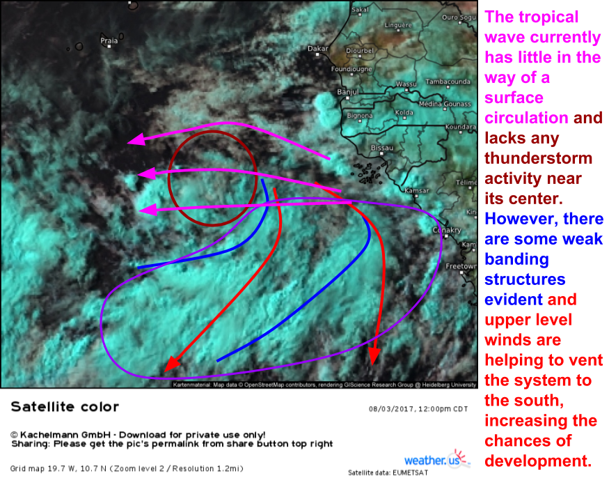
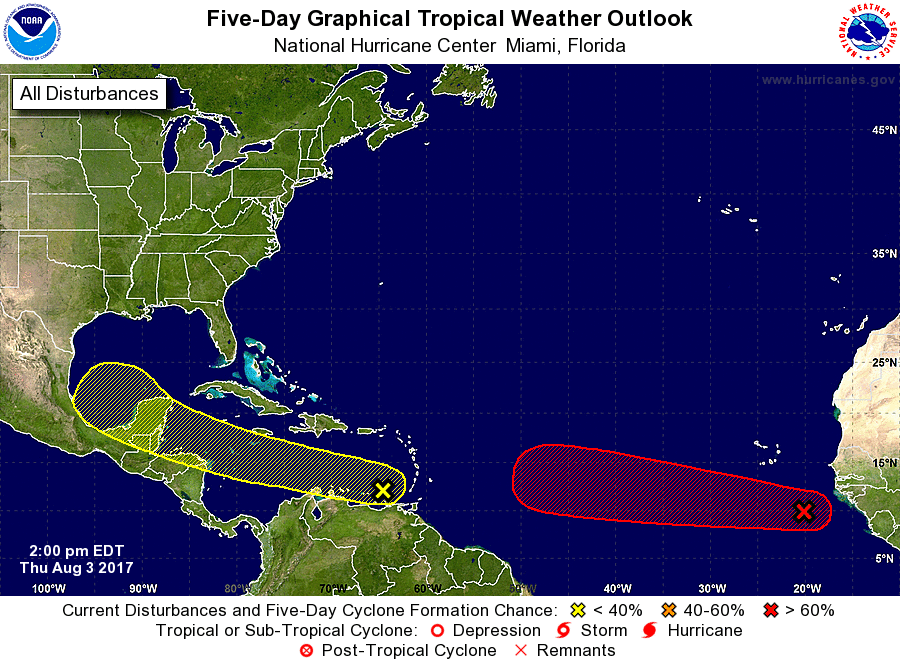
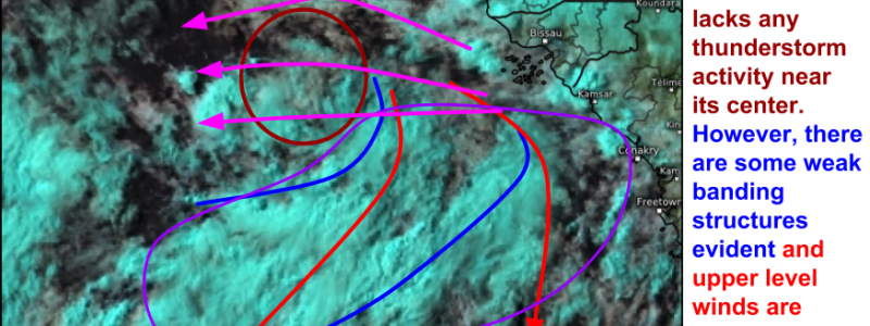
A tropical wave has moved off the coast of Africa and is now moving west across the Eastern Atlantic. Satellite imagery shows that this system still has a long way to go before it poses much of a threat to anything but, as I discussed above, the large scale pattern is favorable for development. If this wave is to develop into anything of significance, it will need to develop deep convection (thunderstorms) around its center, and it will need to develop a circulation at the surface. We can watch satellite animations to see if either or both of these things occurs. If the low level (white) clouds begin spinning around a single point, we know a low level circulation is developing. If more deep blue clouds develop over the center, we know there’s deep thunderstorm activity developing.
So what do the models do with this storm? The short answer is, name a potential outcome and I bet I could find a model that shows it.
There’s currently considerable uncertainty in terms of how strong the storm will be as it moves west-northwest. Potential solutions range from a major hurricane to a disorganized cluster of thunderstorms. We’ll have to keep a close eye on this system to see how it evolves over the next few days.
That’s not the only tropical threat though.
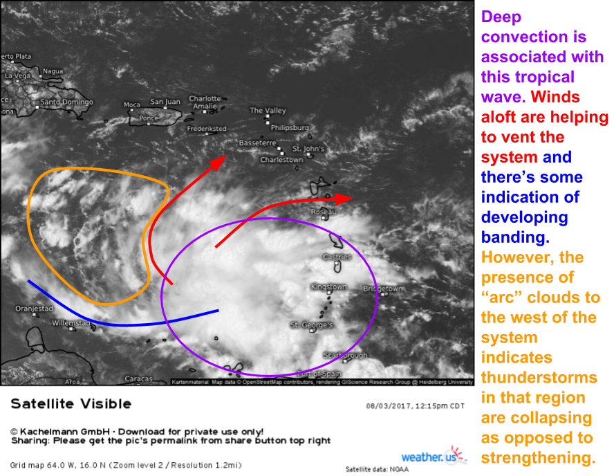
A strong tropical wave is moving into the Eastern Caribbean. Intense thunderstorms are noted with this system, something the Eastern Atlantic wave has yet to develop. However, low level “arc” clouds are noted to the west of the system, indicating that thunderstorms are collapsing. In order for tropical systems to develop, they need thunderstorms to be intensifying, not collapsing. We’ll have to watch closely to see if this trend reverses in the coming days. This wave has decent model support, and may develop by the time it reaches the southern Gulf of Mexico.
Any impacts that the US may feel as a result of these two systems would be about 10-14 days from now. Right now, potential impacts range from a hurricane to mere showers. As these systems continue to develop, we’ll be sure to keep you updated. Despite the uncertainty in the forecast this week, it’s never a bad time to think about hurricane preparedness, especially as the peak of hurricane season approaches. Having a plan for what you’d do if a hurricane were to approach your area will make things go much more smoothly when one does arrive at your doorstep, be it a week or a decade from now.
Here’s the NHC’s thinking regarding the two disturbances. Their general tracks are shown along with their probability of development. I see no reason to disagree with their thoughts.
For more information on the forecast for your location over the next few days, check out the tools we have over at weather.us.
-Jack Sillin
