Coastal Storm Set To Bring Heavy Rainfall To The Mid Atlantic Friday Night
Hello everyone!
The main weather story today will once again be the unusually powerful coastal storm set to develop tomorrow over the Mid Atlantic. Yesterday, we talked about how much uncertainty there was in the forecast. Today, the details are coming into focus. As I always do, I hope to use this space to provide a little bit of the ‘why behind the what’ in terms of the forecast. If you’re just looking to know the ‘what’ (i.e. when is it going to rain at my house? How much? etc.), there’s a wide variety of information available at weather.us to help you. This post will aim to peel back some of the layers of this forecast so you’ll hopefully have a deeper understanding of not only what’s going to happen, but why. With that out of the way, let’s dig into what’s shaping up to be a fascinating event!
In yesterday’s blog post, I emphasized how this storm was likely to slide quickly offshore, limiting impacts both in areal extent and also in intensity. Today’s blog post will be all about explaining why that was dead wrong. This will be an impactful storm across parts of Northern Virginia, Maryland, and Southern New Jersey, among other areas. However, a sharp NW cutoff is still forecast and upstate NY, Northern/Central New England, and interior PA are still forecast to remain mostly dry. So what changed and what will drive the extremely heavy rains?
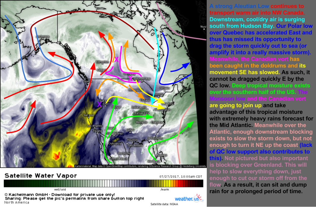
This water vapor satellite map holds all the keys to why the forecast changed. I’ve explained each element a little bit in the sidebar to the right but I’ll elaborate a little bit on the more important parts here. The two biggest developments last night were that the Canadian energy we were watching over Alberta got caught in a bit of an atmospheric no man’s land between several storm systems. The southerly flow ahead of the Aleutian low was trying to pull it northwest (and indeed, a small portion of it is moving northwest). Westerly flow at the base of the Western Canadian ridge was trying to pull it west as well. Meanwhile, northeasterly flow around the monsoon low was trying to pull it south west. Finally, the incoming cold air over Canada was trying to pull it southeast. It’s finally getting caught up in the NW flow and is moving SE but this process took much longer than expected. Therefore, that energy will be late to the party. Because of that, the polar energy that was supposed to drag it out to sea is going to have nothing to pick up. It will exit the scene before the Canadian energy enters. This is the key change from 24 hours ago. Because of this, the storm will have room to slow down and grow before it eventually slides east.
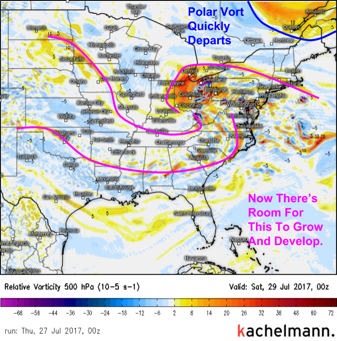
Here’s a much less cluttered map showing why our storm won’t zoom quickly out to sea. It has room to grow and develop now that it missed the train east with the Quebec energy. So what’s the implication of this change? A quickly departing rainfall event has turned into a full fledged Nor’easter. How unusual it is for this to happen in July is hard to overstate.
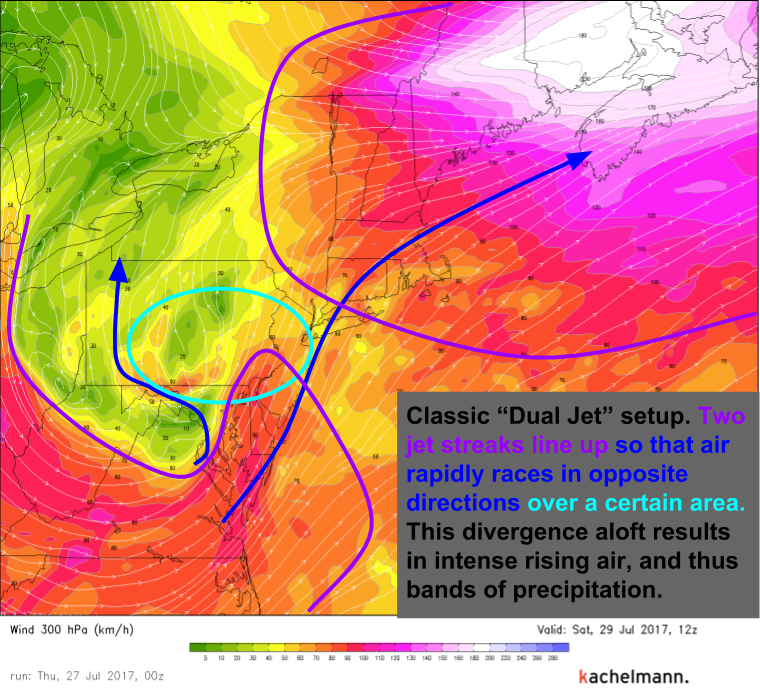
The upper level dynamics for this storm are straight out of a winter storm. Two jet streaks (pockets of unusually strong winds embedded within the jet stream) are aligning just right so that winds aloft over NJ, N MD, N VA, and SE PA will be blowing in opposite directions (dark blue arrows). This creates a vacuum aloft over these areas and air from the low levels must rise to fill the void. This rising motion results in heavy precipitation where divergence aloft is maximized. On Saturday morning, that will be the aforementioned NJ-SE PA-N MD-N DE areas. The DC area will get in on the action Friday night.
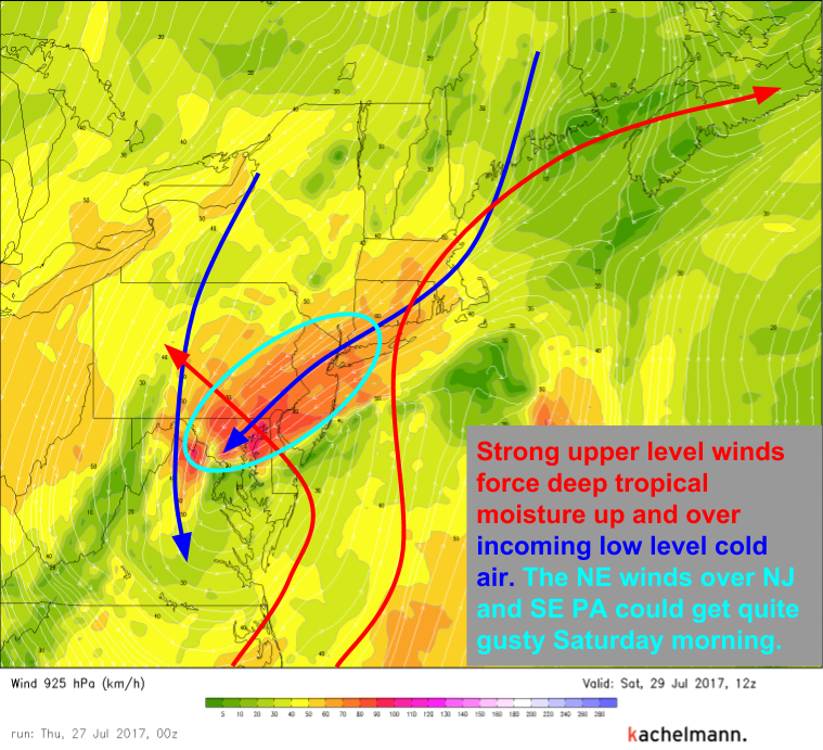
In the lower levels, dynamics are just as impressive. NE winds will intensify as the low offshore does on Saturday morning. Winds are likely to gust over 45 mph along the NJ coast. That’s tropical storm strength!. Meanwhile, the contrast between the incoming low level cold air and the incoming upper level warm/moist air will help to fuel extremely heavy rains.
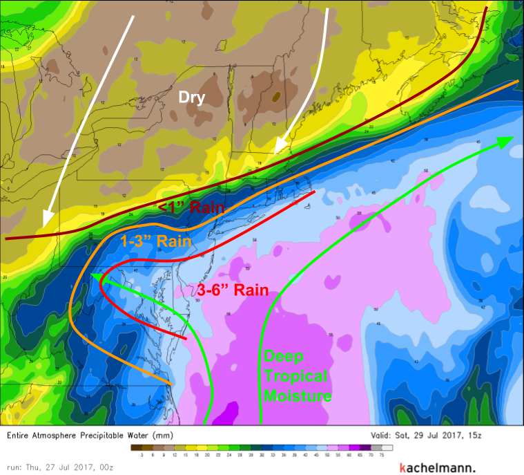
This map shows well the overall distribution of moisture during the event. Cool dry air will be surging south out of Canada while deep tropical moisture will be moving north from the tropical Atlantic. The result will be a very sharp cutoff between rainfall amounts over 3″ and hardly a drop at all.
Because the storm is missing the train east, and there is a ridge of high pressure near Bermuda that’s helping to keep the storm stuck in place, everything will move very slowly on Saturday. The storm will move slowly, as will its bands of heavy rain. With the deep tropical moisture and incoming cold air (both discussed above), it’s hard to overstate how hard it will pour over S NJ, SE PA, and N VA/MD/DE on Saturday morning. A band of torrential rain is likely to set up over these areas late Friday night and it’s not going anywhere until Saturday morning. Swiss model forecasts indicate rain rates under this band will be on the order of 1-1.5″ per hour. In the sequence above, we see that band lingering over the same areas for at least 4 hours. Lighter rain will impact these areas for much more than 4 hours. In these areas, isolated reports of 6″ rainfall totals would not surprise me. This is a very large flooding risk!
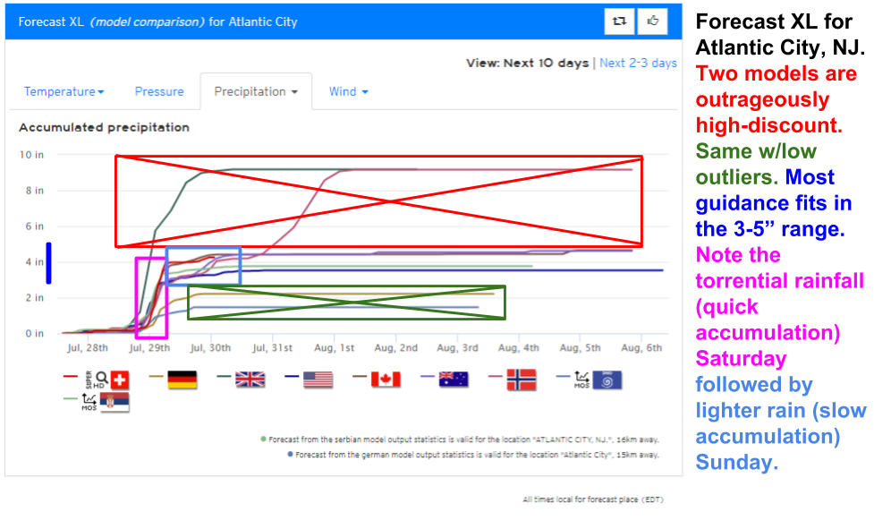
Rain will slowly depart the coast on Saturday night, but it could linger over parts of the Jersey shore and the Delmarva region through parts of Sunday. Here’s the forecast XL product for Atlantic City showing the evolution of the storm in terms of rain rates.
The storm will be safely offshore by Monday and the rest of the week looks mainly quiet for this area to dry out/clean up. If you live in S NJ, SE PA, N VA, N MD, or N DE, and your location is prone to flooding, now is the time to prepare! Move valuable items up to the second floor, check your sump pumps, etc. There’s going to be a lot of water falling in these areas in a fairly short period of time Saturday morning with light/moderate rain continuing through Sunday. Gusty NE winds will also push water up along the coast and a 1-2 foot storm surge is forecast along the Jersey shore and along the E/NE facing portions of the Delmarva area. Thankfully, tidal cycles are at their monthly minimum but splashover/inundation of low lying areas is certainly possible during high tides Saturday night and Sunday morning.
Quiet weather continues across much of the rest of the country with only scattered showers and storms expected this afternoon. For more details on your local forecast, go on over to weather.us.
-Jack Sillin
