Rare July East Coast Coastal Storm To Develop This Weekend
Hello everyone!
Today’s weather is fairly quiet across the country so I’m going to focus on the weather for the weekend, seeing as it is quite fascinating. If you’re looking for today’s forecast, the tools and information on weather.us have you covered!
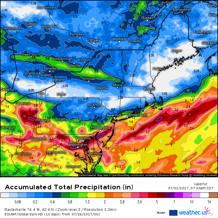
Low pressure is forecast to develop off the Mid Atlantic coast on Saturday as a cold front moves south and east. This setup is highly unusual for July, we typically don’t see coastal storm development kick in until late September or October. The pressure in the developing low is forecast to drop below 1000mb, a sign of a reasonably strong storm, especially for this time of year.
As with any developing coastal storm, bands of heavy precipitation are forecast to develop NW of the low’s center. However, these heavy rain bands will have to fight an impressive surge of very dry air coming south out of Canada. I’ll talk more about this surge of dry air in a moment, because it’s extremely impressive, but for now, just know that the dry air will limit how far northwest the heavy rain can get. DC is locked in for a heavy rainfall event, as is Nantucket. NYC is right on the edge and it could go either way. Boston, meanwhile, has a decent shot at remaining mostly dry. However, there is a fair amount of model disagreement. Some data suggests that the jackpot lies somewhere around NYC while Boston sits at the edge of the heaviest precipitation.
There’s a fair amount of uncertainty regarding the low’s exact track, and thus the placement of the heaviest precipitation. To resolve the differences, we look at the large scale pattern. Believe it or not, the weather over Northern Canada can have a big impact on our weather here in the US!
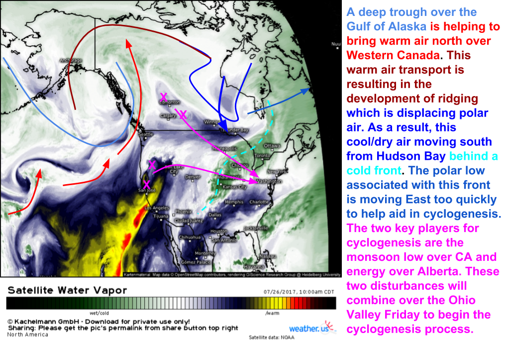
Here’s a graphic I made depicting all of the ingredients for our storm to form in their current state (as of 11 AM EDT). The most important features to note are the large ridge building across Western Canada and the low near James Bay. The ridge is important because the heat transported north through it displaces polar air southward (what goes up, must come down). This southerly push of polar air is very important to our cyclogenesis process (in case you don’t know what cyclogenesis means, it translates literally to the beginning (genesis) of a storm (cyclone)). The other feature is the low over Quebec/Ontario. This low is helping to drive the cold air south behind a cold front that is moving through the Midwest.
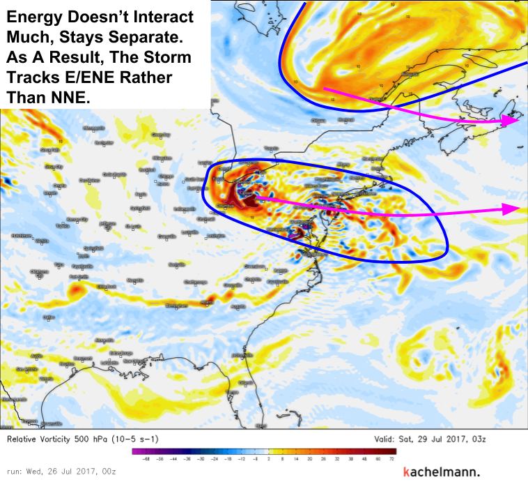
The key to me is this map right here. This shows upper level energy at about 20,000 feet. The low currently over James Bay shows up on Friday night over Eastern Quebec. The energy now in Alberta shows up here over the Ohio Valley and Mid Atlantic. Notice how the two stay separate. If we were going to see a big, wintertime nor’easter type system, we’d need to see that energy over Quebec dig southwest and interact with the Mid Atlantic energy. This interaction would help to pull the storm NW closer to the coast. However, this interaction is not forecast to occur on Friday night. As a result, our storm is forecast to track ENE away from the coast, with impacts limited to the shorelines and adjacent coastal plain areas as opposed to a more “typical” nor’easter which would feature impacts all the way up the Appalachian mountain chain.
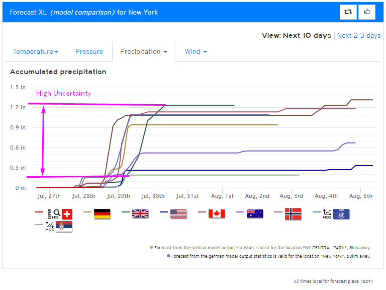
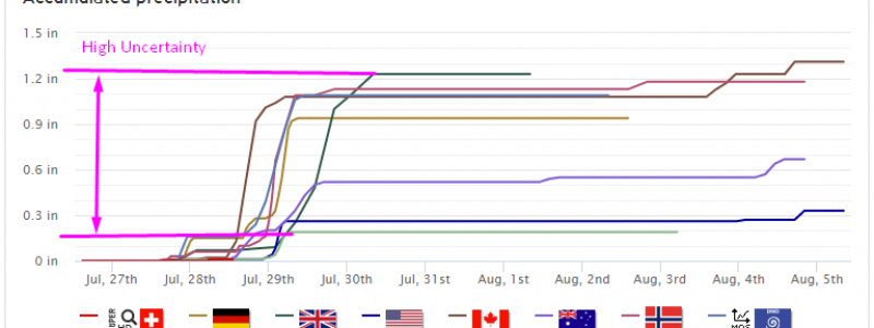
A look at our Forecast XL product for NYC shows exactly the uncertainty I’m talking about. Notice how some models forecast over an inch of rain while other models suggest barely .25″ is possible. Exactly where the sharp cutoff sets up has yet to be determined.
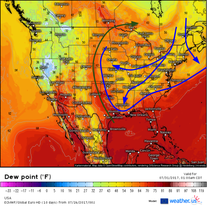
Behind the storm, the bigger story will become the unusually cool and dry air that floods south. Dew points will drop into the 50’s and low 60’s as far south as the Gulf Coast!
As Canadian high pressure builds into the Eastern half of the country, relief from the typical summertime heat and humidity is expected. Temps will drop into territory comfortably below seasonal norms and dew points will feel extremely refreshing as north winds beat back the moisture from the Gulf of Mexico. Meanwhile to the west, the Gulf of Mexico moisture will be surging north just East of the Rockies to set up yet another chance for severe storms next week. More on that as we get closer. Our late Summer pattern continues to roll along.
-Jack Sillin

