Widespread Severe Weather Expected As A MCS Rolls East Tonight
Hello everyone!
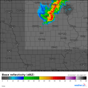
Active weather is once again in the forecast as our Northwest Flow pattern powers on. A strong disturbance that moved onshore in California last night has caused very strong thunderstorms to develop across South Dakota which have now moved into far SE parts of Minnesota. This Mesoscale Convective System (MCS) will produce a swath of damaging winds as it moves towards the Great Lakes this evening. Eventually, its impacts will be felt all the way to the Atlantic coast.
Everything about this line of storms and its environment are extremely impressive. Without going into all the nitty gritty technical details (that could take a really long time!), just know that these storms are intense and are producing a wall of 50-65 mph winds as they move east-southeast. A few of the little kinks in the line could produce tornadoes and as of 5:30 PM, CDT, several tornado warnings were in effect.
Thankfully, the storms are moving quite quickly and their fast motion will limit the potential for large scale flooding but a quick inch or two of rain could cause quick flash flooding issues in areas with poor drainage.
There is also an incredible amount of lightning associated with these storms including at least one strike that was observed dozens of miles away from any precipitation. If you’re close enough to a storm to hear thunder, you’re close enough to be struck by lightning!
So what’s next for these storms, and what impact will they have on the weather in places like NYC?
The disturbance aloft that formed these storms is getting a bit of a kickback for its efforts in that the storms are pumping massive amounts of energy into the upper atmosphere, allowing for this disturbance to strengthen. A couple different storm complexes (Mesoscale Convective Systems) are expected to form and die as this disturbance rolls southeast.
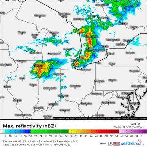
By tomorrow morning, it’s a good bet that one or two fairly strong storm complexes will be ongoing across the Great Lakes. It’s hard to tell exactly where these will set up but one in the Chicago area and one farther northeast is probably not a bad guess. The HRRR model illustrates this thought well, in my opinion.
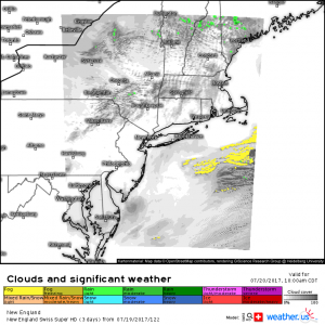
Meanwhile in the northeast, the Swiss HD model is likely to be correct in its prediction of sunny skies tomorrow morning. A few pop up showers are possible across the high terrain of the Catskills, the Adirondacks, and the White/Green mountains of Northern New England, but otherwise sunny skies are expected. The marine layer is also expected to be kept more or less at bay as a very weak front leftover from today drifts offshore.
The sunny skies are important because they allow for temps to rise during the morning hours, becoming hot by the early afternoon. Hot and humid air is great fuel for thunderstorms so when the strong upper level disturbance enters the area tomorrow afternoon, there will be a powder keg awaiting. For more on why hot and humid air is fuel for thunderstorms, check out my explanation here.
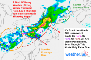
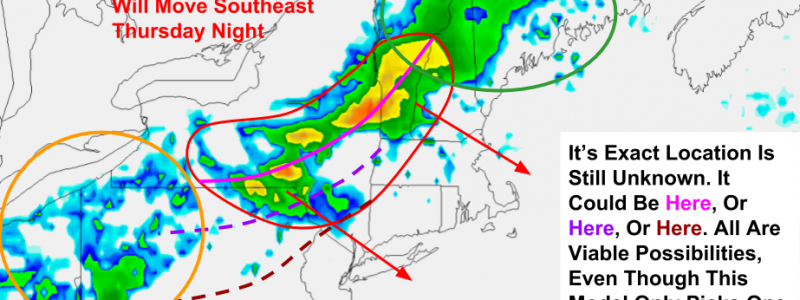
Here are my general thoughts in terms of impacts for the northeast. There will likely be a “core” of strong to possibly severe storms that moves SE across some area including parts of NY and northern PA. The exact location is still to be determined but potential options are shown on the image. There’s only so much room for variance given the wind patterns aloft. It could extend as far north as Albany NY-Manchester NH (would be if bright pink line verified) or as far south as Southern PA-Central NJ (if dark red line verified). Along the line of heaviest storms, gusty winds will be the main threat along with lightning and heavy rains. Overall, this is not a huge event, but it is unusual due to its nighttime nature. The image shown is valid for 11 PM Thursday night and shown is the approximate location of the line of storms. It will move offshore by the wee hours of Friday morning. Areas away from the “core” will experience much lighter impacts with steadier rains across parts of Northern New England and spottier/weaker thunderstorms across Ohio, Southern Pennsylvania, and points east. Right now, it’s pretty likely that NYC itself sees part of the “core” (not really a true core like the one we’re seeing right now across Iowa, but still the area of strongest impacts relative to other areas) around or a little after midnight.
I will likely have another post tomorrow morning updating everyone on what to expect but thankfully, with weather.us, you don’t need to wait for me to know what’s coming! All through the day, watch our high resolution model guidance, our HD Radar products, our GOES-16 satellite data, as well as countless other tools that we have available.
Have a great evening and be sure to stay ahead of the weather if you live in the expected path of the storms tonight and tomorrow!
-Jack Sillin
