Severe Storms In The Ohio Valley This Afternoon And Evening
Hello everyone!
As of 3:30 this afternoon, the most active weather is located across the northeast quadrant of the country with torrential rains and severe thunderstorms both ongoing. A developing coastal low pressure system and the cold front that brought yesterday’s Wisconsin severe weather are both contributing to the active situation. From west to east, our first focus will be on severe weather.
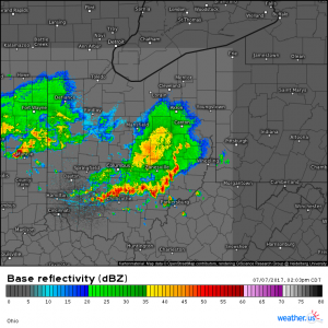
A pair of Mesoscale Convective Systems (MCS’s) are moving across Indiana and Ohio at the moment and some of the leading cells have pockets of strong winds and potentially large hail. These MCS’s are drifting east-southeast and will move into parts of Southern Ohio, Southeastern Indiana, Northwestern West Virginia, and Western Pennsylvania in the coming hours.
As the clusters continue to evolve, damaging winds will likely become more widespread along the leading edge. The storms will diminish in strength as they head towards the Appalachian mountains this evening. Locally heavy rain that could result in flash flooding is also expected with these storms so take care if you have to travel in these areas.
Track the heavy rain with our high resolution radar as well as the lightning with our lightning analysis tool.
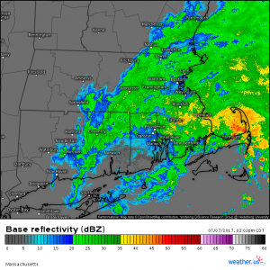
Farther east, torrential rains are continuing across Eastern Massachusetts as a coastal storm moves offshore. Deep tropical moisture is in place across the area as the storm moves through and torrential rains are falling as a result. Radar loops and wind direction observations indicate that the center of the storm is located just west of the western tip of Martha’s vineyard as of 3:15 PM EDT. Street flooding is being reported at numerous locations both in Rhode Island as well as Southeast Massachusetts so avoid traveling in these areas if possible. Rain will continue for another few hours before tapering off tonight. The latest Swiss Super-HD model data suggests that most of the rain will be offshore by 6 PM EDT.
In between these two features, there are scattered showers and storms developing along a weak surface trough that is located across parts of upstate New York. No severe weather is currently present with these storms but they are embedded within an airmass similar to the one over SE MA. This is resulting in very heavy rain with several flash flood warnings in effect. Track the storms with our high resolution radar as well as with GOES-16 satellite imagery to see if anything is headed your way.
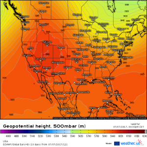
The rest of the nation is reporting generally calm weather at the moment as a large ridge of high pressure dominates the Western two thirds of the country. This ridge of high pressure is expected to remain firmly in control through much of next week and possibly beyond while troughing in the northeast (cooler colors on the map) keeps active weather in the mix for the Great Lakes and Northeast.
I’ll have more info on future weather stories in the coming days.
Stay safe if storms are headed in your direction this evening!
-Jack Sillin


