92L Slowly Organizing Over The Deep Tropical Atlantic, Medium-Range Forecast Remains Highly Uncertain
Hello everyone!
Since Hanna has moved onshore in Texas and is currently dissipating over Mexico, our attention has shifted to a tropical wave in the central tropical Atlantic (dubbed 92L by the NHC). 92L is currently producing disorganized shower and thunderstorm activity but is expected to become tropical depression 9 this week. If you’re reading this as a resident of the US East Coast concerned about the potential for a tropical cyclone threat in the next 10 days, the most important message at the moment is that there’s no direct threat to you from 92L as of now. That might change down the line, but speculating about US impacts over a week before the system would arrive at our shores doesn’t do anyone any good. I’d encourage you to get in the habit of briefly checking the tropical weather forecast once each day to make sure you’re up-to-date with 92L in case it does become more of an issue. Otherwise, there’s plenty of other problems in the world more deserving of your time and attention at the moment. This post is mostly geared towards those who have an interest in tropical meteorology. If you want a look “under the hood” at how forecasters are thinking about uncertainties related to 92L, you’ve found a post that hopes to do just that.
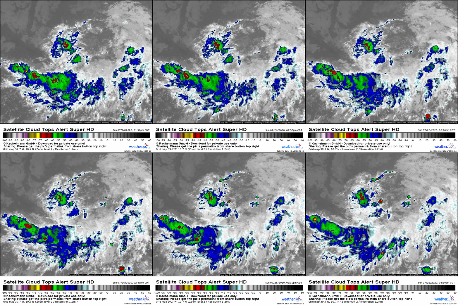
Satellite imagery of 92L is hardly show-stopping this afternoon. The system has very sparse convective activity that has mostly been focused in a poorly-organized band south of the incipient center. That said, satellite imagery does show hints of a favorable upper-level environment (note the upper-level cirrus clouds spiraling away from the system in a clockwise pattern). Given that late afternoon is the diurnal convective minimum in the tropics, modestly warm sea surface temperatures under 92L at the moment, and the climatologically-supported stability of this part of the Atlantic in late July, I’m not surprised to see this. The system is also dealing with a little bit of dry air to the north which I suspect is also helping inhibit convective activity.
92L won’t develop into TD9 until it is able to maintain intense thunderstorm activity (deep convection) over its center for a prolonged period of time. So when might that happen?
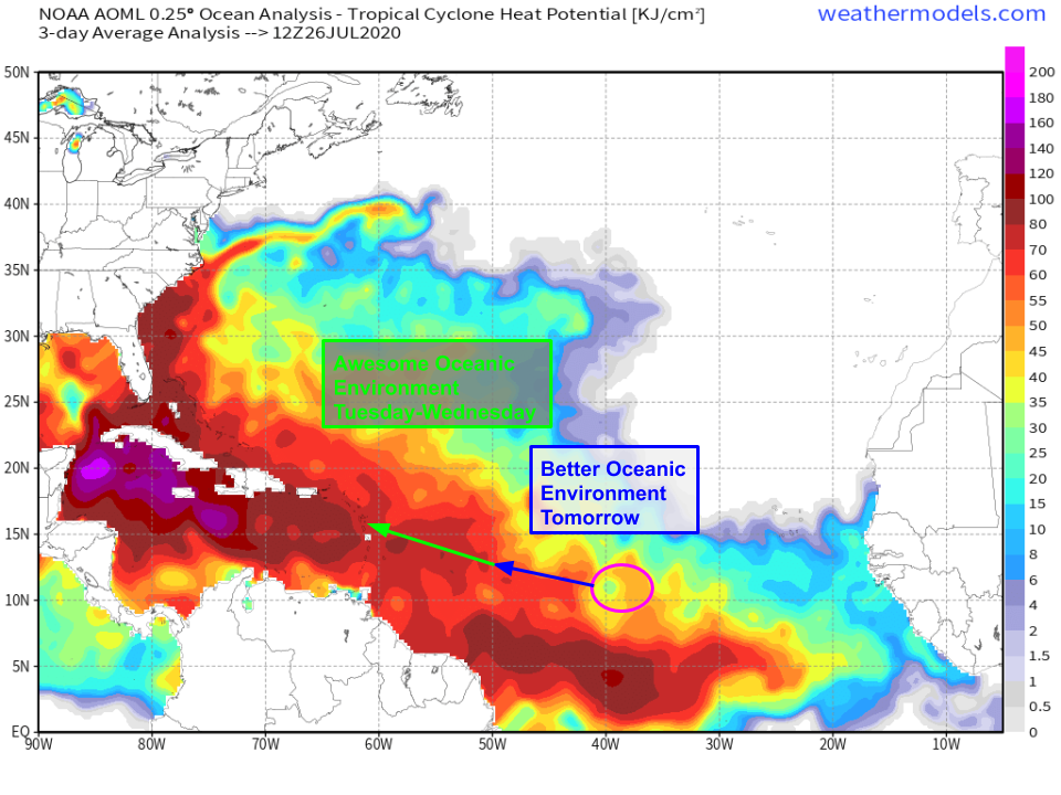 One clue can be found in the oceanic environment over which 92L will be traversing. The system is currently located in a region of modestly warm waters that are supportive of tropical cyclone development, but not overwhelmingly so. Given the climatological tendency towards stability (air parcels unable to remain warmer than their environment), the threshold for what counts as favorable for tropical cyclone development are a bit higher than they otherwise might be. So where you usually need 26-27C SSTs to support tropical cyclone development, in this case, 92L will significantly benefit from the presence of 28-29C SSTs (dark red colors on this map of oceanic heat content) west of 50W. So I’d expect to see a bit more convective activity tomorrow before a more substantial ramp-up on Tuesday and Wednesday.
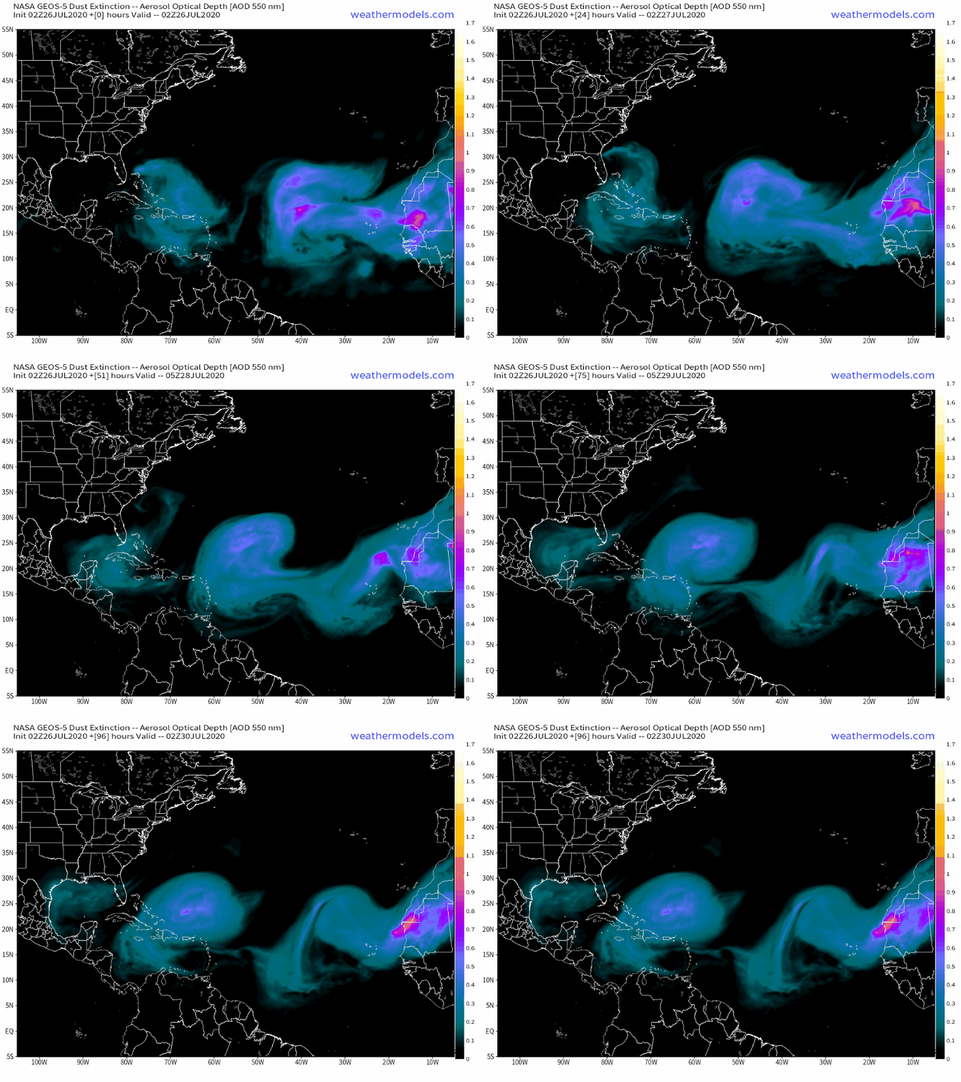 By Tuesday and Wednesday, guidance also suggests that 92L will break free of the Saharan Air Layer currently located to the north of the system. When SAL air gets ingested into tropical cyclones, it interferes with thunderstorm activity and is quite good at snuffing out tropical cyclones as they’re developing. I don’t think the SAL will be a huge issue for 92L, but shaking (some/most of) its influence will certainly help give convective activity a boost by Wednesday.
Of course there is some uncertainty regarding how quickly this process unfolds. Some guidance suggests that convection could develop and persist tonight with a tropical depression forming by tomorrow night. Other guidance struggles to develop the system at all, taking it into the Caribbean as an open wave.
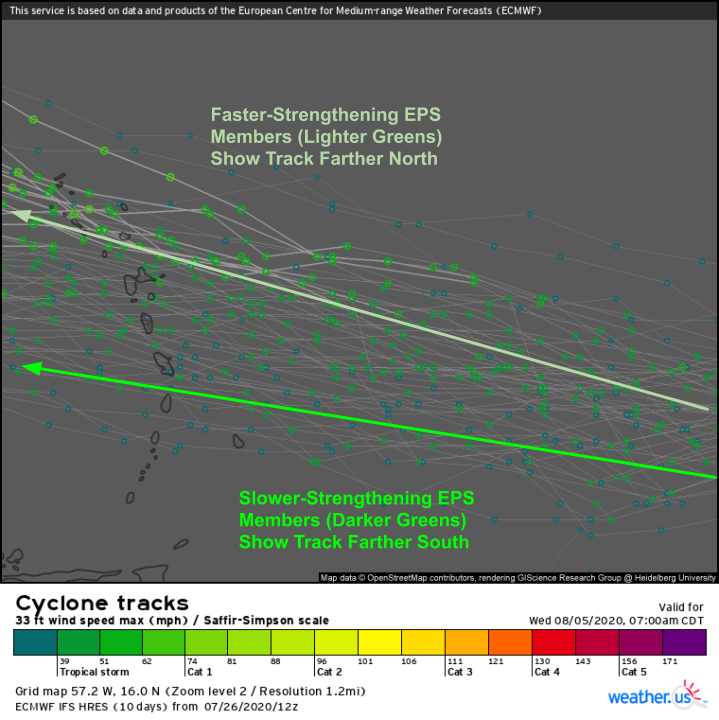
Here’s a look at 12z EPS data which shows the range of possible track and intensity solutions for 92L as it approaches the Lesser Antilles. Note that there is some dependence of the forecast track on the forecast intensity. Members showing more strengthening of 92L take the system farther north while members showing a weaker 92L keep the system farther south. This is because a weaker system will be steered exclusively by the strong Bermuda-Azores high dominating the central Atlantic while a stronger storm will “feel” other features higher in the atmosphere that are shifting flow a little more towards the southeast rather than due east.
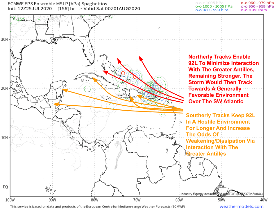 None of this is new information today. I included this graphic in yesterday’s update and it’s still applicable now. 92L will find a fork in the road on Wednesday, at which point it will either be a coherent system moving west-northwest (or northwest) on a course north of the Greater Antilles or it will be a disorganized tropical wave drifting east into the Greater Antilles or eastern Caribbean. If the latter scenario ends up coming to pass, US impacts from 92L would be quite unlikely. The system would have to wait until the western Caribbean to develop before turning north into the Gulf for that to happen, and the odds of that happening at this time of year are quite long. The northern track would leave a wider door open for US impacts, though an impactful solution would not be guaranteed even if we had a hurricane moving north of Puerto Rico by next weekend.
What might lead 92L to struggle even if it avoids fizzling out over Hispaniola or in the Caribbean?
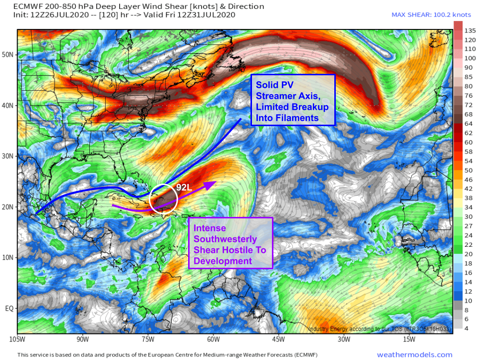
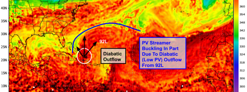
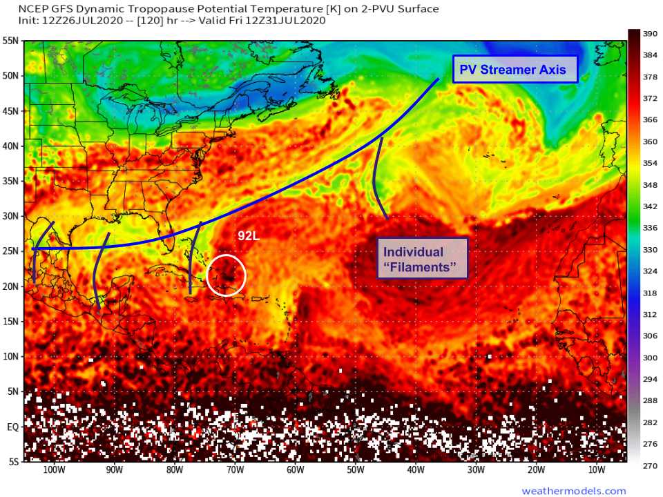 The answer lies in a Potential Vorticity Streamer (PVS) that is developing now in response to an anticyclonic wavebreaking event over the East Coast. What’s a PVS? In simple terms, it is a pool of stratospheric air that has made a downward intrusion into the upper troposphere. Where you see PVS features, you also typically see conditions that resemble mid-latitude upper-level lows: dry air, wind shear, and baroclinic cyclones. Recall that these conditions are hostile to the development and maintenance of tropical cyclones. So even if 92L emerges into the SW Atlantic as a coherent tropical storm, it may struggle as it runs headlong into this PVS feature.
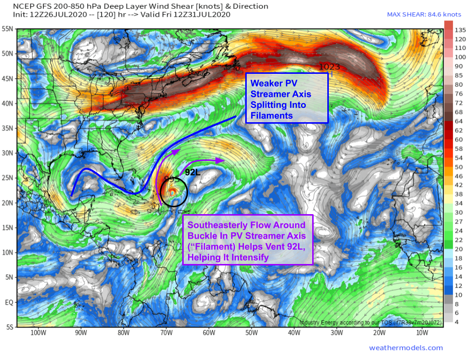
The upside for 92L is that this PVS will be splintering into a bunch of different “filaments” or individual upper-level lows as this interaction draws near. This fragmentation is a normal part of the PVS lifecycle, but there is some uncertainty regarding how quickly it will occur.
The ECMWF model sees the PVS fragmentation happening a bit more slowly. This would put 92L (if it were to be north of Hispaniola) under a swath of extremely intense southwesterly wind shear. Even if 92L were a hurricane at this point, it would be ripped to shreds by shear in excess of 60 kts. A tropical cyclone simply cannot survive in conditions like that.
Meanwhile, the GFS model suggests that the PVS will fragment a bit sooner. This would mean that 92L would actually be assisted by its proximity to the PVS because southeasterly diffluent upper-level winds to the east of the ULL over the Bahamas would help vent the system. The difference between a PVS ripping a tropical cyclone to shreds and helping it rapidly intensify is surprisingly subtle, and it’s definitely not clear which scenario is more likely in this situation.
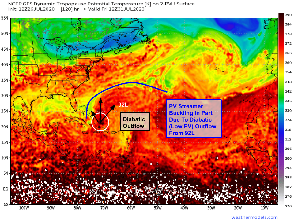 Interestingly (and frustratingly for forecasters), the source of this discrepancy between the ECMWF and GFS handling of this PVS may in part be attributable to the uncertainty in 92L’s pace of development. The GFS is faster to develop 92L into a strong tropical storm as it approaches the Lesser Antilles. As a result, it is expecting 92L to release much more latent heat into the upper atmosphere as it approaches the PVS (which, remember, is a region of cool and dry air aloft). This surge of warm air venting away from 92L’s center is actually one of the reasons that the GFS is expecting the PVS to fragment more quickly. So we might not know the extent to which 92L will weaken as it approaches the Bahamas until we know how strong it is as it approaches the Lesser Antilles, even if guidance otherwise has a good handle on this PVS (the fragmentation of which will be driven in part by processes external to 92L).
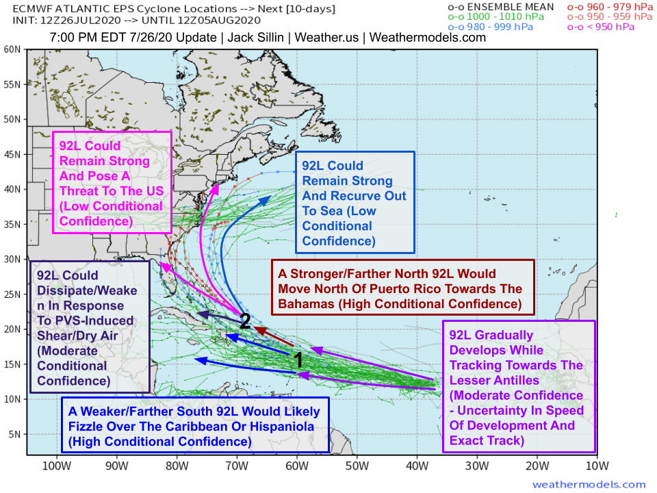 So where does all that leave us? With a very uncertain forecast even as soon as Wednesday/Thursday. The annotated EPS graphic above spells out the various sources of uncertainty. I’ve labeled two cutoff points (1 and 2) where the storm will clearly be moving in one particular direction or another. These can be thought of as forks in the flow chart of where 92L ends up. At point 1 (NE Antilles), it will either follow the southern path into the tropical cyclone graveyard of the NE Caribbean/Hispaniola or it will follow the northern path towards the SW Atlantic. If it’s on the northern path, then we’ll have to start thinking about the PVS and its uncertainties. If the storm survives the PVS or is enhanced by interaction with it, then we’ll have to have a discussion about tracking nuances that would push the system either towards an impactful outcome along the East Coast or towards a less-impactful outcome recurving out to sea. As you can see, the solution where substantial impacts are felt in the US is just one of many, and far from the most likely at the moment. A majority of EPS members take 92L along the southern track at inflection point one. Of those that don’t, a majority either dissipate the system in the Bahamas or sent it out to sea. Just 5/51 members keep the storm strong enough and close enough to the US East Coast to produce substantial impacts. Could it happen? Yes. Is it something to worry about now? Not as of now.
-Jack
