92L Likely To Develop This Week, May Pose A Long-Term Threat To The US
Hello everyone!
With Hurricane Hanna now headed inland over southern Texas, it’s time to begin keeping an eye on the next tropical disturbance that could become a threat to the US in the long term. It’s important to remember that any impacts in the US would occur in 7-10 (+) days, so we still have plenty of time to watch this. If you live along the East Coast or Gulf Coast, at this point there’s no reason to be concerned about 92L. One thing I hope to do in this post is show you the range of possible outcomes from this system which includes many low-impact scenarios (never develops, weak TS drifting through the Caribbean, recurve well off the East Coast) in addition to those that would cause more problems.
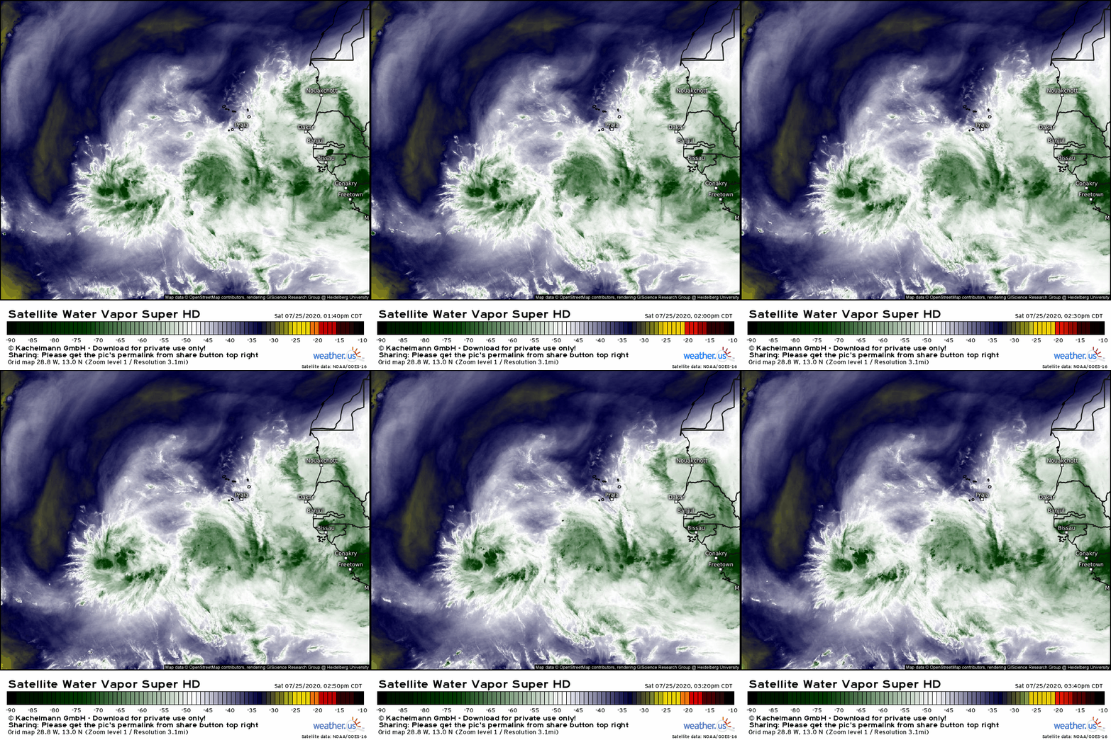
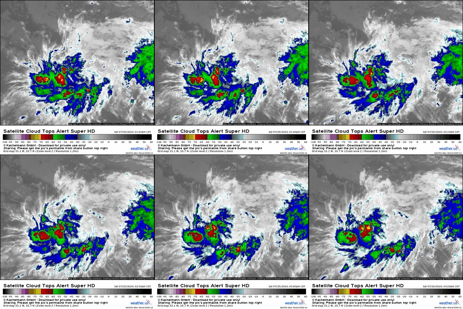 Satellite imagery shows 92L drifting west over the central tropical Atlantic. The system doesn’t currently have a ton of deep thunderstorm activity associated with it, but that’s somewhat expected this time of day and doesn’t present a big red flag as of now. Even during the “diurnal minimum”, the system is still firing off several updrafts with cloud tops below -70C. In the upper levels, the system has the benefit of an anticyclone as seen by the cirrus clouds blowing off to the southwest on the southern flank of the system and off to the north on the northern flank of the system. As of now, 92L doesn’t need to worry about any shear-related disruptions.
WV imagery shows a bit of dry air to the west and northwest of the storm, but there’s no hint of dry air near the center. While we’ll have to keep an eye on possible dry air intrusions as the system continues moving west (rather briskly), 92L doesn’t appear to face a major fight with the Saharan Air Layer like Gonzalo. This is one of the key reasons why this wave is much more likely to develop than most we’ve seen so far this season.
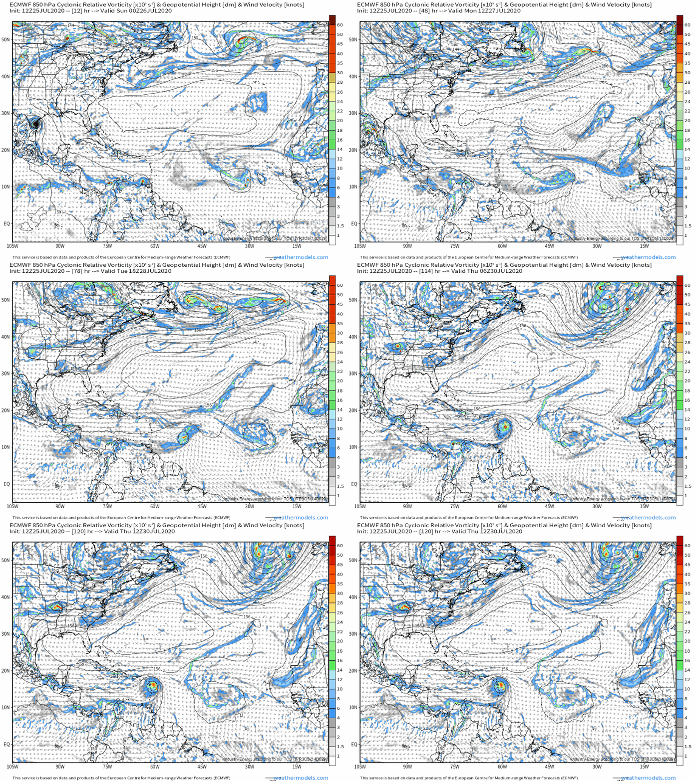
92L will continue moving quickly to the west over the next couple days before drifting a bit more towards the northwest by Tuesday/Wednesday as it approaches the Lesser Antilles. This motion is the result of a straightforward steering pattern on the southern edge of the Bermuda-Azores high which is quite strong and extends from Portugal to Mexico. As it cruises westward, 92L should acquire a closed center of circulation and become TD 9. Exactly when this happens is still unknown, and is a source of uncertainty in the medium/long-range timeframe. The stronger 92L gets, the less it will be pushed around by the Bermuda-Azores high, and the more it will be able to drift northward.
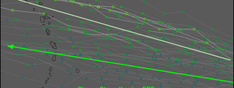
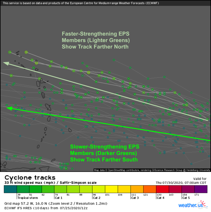 This pattern emerges clearly when you look at EPS forecasts for the system. The EPS members that forecast faster development of 92L show the system tracking farther north, while the members that are slower to develop the system initially keep it farther south. This sensitivity of the medium-term track forecast to the near-term intensity forecast is one reason why medium and long-range forecasts for 92L are so uncertain. We don’t know where the storm will go later this coming week until we know how quickly it develops. Figuring out how quickly it develops is a matter of predicting small-scale convective interactions (when a cluster of thunderstorms can pop up in the right place and persist for a long enough time to form a circulation) that are nearly random. Hence the question marks popping up with the day 4-5 track forecast (which of course is crucially important to the longer-term track and intensity forecasts).
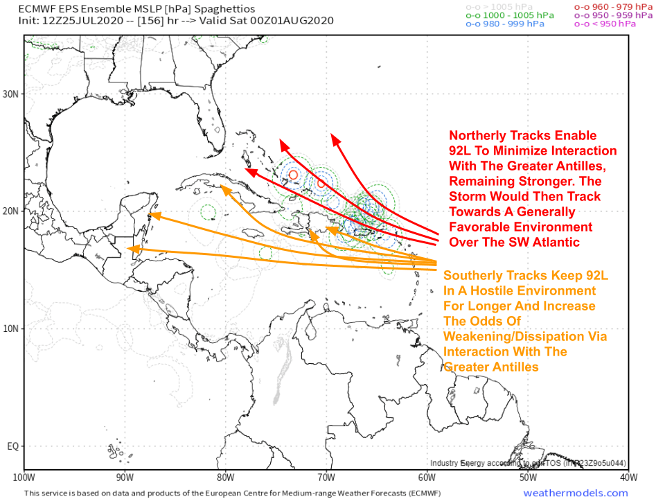 By the end of the week, 92L (or TD 9 or Isaias depending on its strength) will either be fading over the Caribbean (where conditions will be hostile for tropical cyclones), dissipating over the mountains of the Greater Antilles, or intensifying to the north of Puerto Rico/Hispaniola where much more favorable conditions will likely be present. Remember: which of these outcomes actually occurs will depend on how the storm behaves over the next few days. It’s just too early to lean in one direction or the other. We should have a better idea by Tuesday or Wednesday.
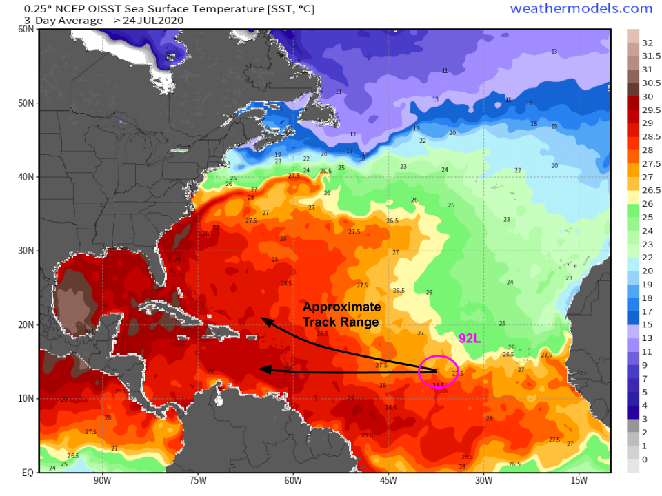
92L is currently sitting over moderately warm waters (26.5-27.5C) and will continue moving over waters of roughly that temperature for the next 24-36 hours. After the system passes 50-55W, it will enjoy much warmer water temps (28-29C). While that might not seem like a huge increase, it makes a huge difference for developing tropical cyclones because increasing the water temperature by a little bit increases its available energy by a lot. It also makes the atmosphere more unstable (assuming conditions higher up in the atmosphere don’t change drastically) which enables easier “access” of that thermal energy by our developing storm. So if I had to pin down a formation window, I’d guess it would be just after 92L crosses into that region of warmer waters sometime on Monday or Tuesday.
What happens if 92L does clear the Greater Antilles with minimal disruption? There’s no way of providing a definitive (or even semi-definitive, or even somewhat useful) answer at this point. We’d have to go through the whole process of figuring out which features are responsible for its steering, how strong those features are, where they’ll be, and so on. If you want a look at what that process looks like, read back to last year’s discussion of Dorian when it was located in the southwestern Atlantic. I’m not going to entertain much discussion of the system’s future past Hispaniola until it’s clear that it will survive past Hispaniola. Until then, we’re in “watch and wait” mode across the entire US coastline from Texas to Maine.
Many more details to come as 92L’s future becomes clearer.
-Jack
