4/26 Weekend Outlook: Steady Rain And The Threat Of Snow Return
Hello everyone!
This weekend, our focus will shift from severe thunderstorms to two systems that will bring more widespread steady rain, and even a little bit of snow. The video below will be a quick synopsis of the major systems forecast to impact the US from tomorrow through Sunday. I’ll explain in a little more detail the snowy setup in a longer discussion section below the video.
General Discussion Video
Northern Plains Snow Extended Discussion
A cooler airmass will be moving south across the northeastern part of the country on Friday night in the wake of the stronger storm developing in New England. This will strengthen the thermal gradient between the hot Desert Southwest and the now-colder Northern Plains. A disturbance will move along this gradient on Saturday, tapping into a robust supply of baroclinic energy (that’s the energy that’s stored up in a strong atmospheric thermal gradient) to produce a band of heavy precipitation. The cool airmass to the north of this disturbance, combined with the dynamics of the band will result in much of that precipitation falling as snow, despite the fact that it’s almost May.
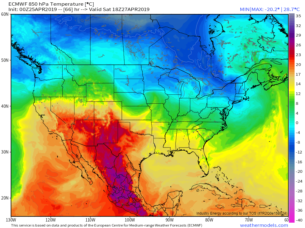
Featured Product: ECMWF 850mb Temperature, available with any weathermodels.com subscription
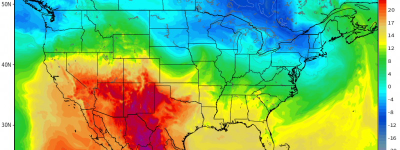
This process can be visualized many ways, but one of the best comes with this map that just shows the temperature at about 5,000 feet above sea level. The storm over New England is clearly visible with warm air moving north ahead of it, and cold air moving south behind it. That cold air moving south can be seen splitting into two branches after it moves out of Hudson Bay in Canada. The first branch continues southeast towards New York and New England, and will contribute to some higher elevation snows in that region. The second branch can be seen making a left near the UP of Michigan, before heading towards our disturbance in SD. The disturbance itself can be found along the SD/NE state line at the center of the developing swirl of warm and cold air. It’s right along the leading edge of the warm air that we’ll look for our band of heavy snow across S MN, N IA, and S WI.
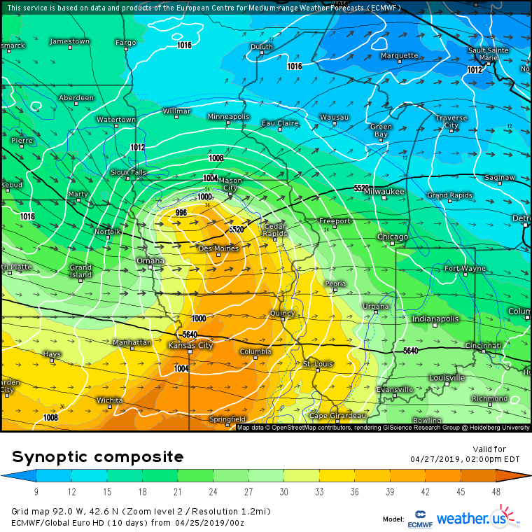
Featured Product: ECMWF Synoptic Composite, free from weather.us (tutorial video here)
The ECMWF’s Synoptic Composite map does a good job highlighting the dynamics going on “under the hood” of this event. If you look at the shading, that’s your measure of warmth/moisture, and the plume of warm moist air is easy to spot running into the cooler/drier airmass between Sioux Falls and Mason City. The black arrows represent 300mb (upper level) winds, and a jet streak can be seen moving from Pierre SD down towards Omaha NE and eventually over towards Cedar Rapids. This jet streak is cyclonically curved, meaning it turns to the left as you move down its long axis. In a cyclonically curved jet, we look to the left exit region for enhanced upward motion, which happens to be located in the same area we’re seeing the warm moist air run into the cold dry air (N IA/S MN). The black lines represent 500mb heights, which give a good sense of where our disturbance is (located just ESE of Sioux Falls). The upward motion ahead of the disturbance will give another boost to the dynamic lifting mentioned above. Finally, the white lines represent sea level pressure isobars so you can spot the low pressure system near Des Moines which is merely the surface reflection of the upper level dynamics discussed above.
Featured Product: Hourly ECMWF Precip Type, available with any weathermodels.com subscription
The net result of all those dynamical processes is visualized nicely by the ECMWF’s hourly MSLP/Precip Type forecast shown here. As the disturbance emerges out of the Rockies, low pressure develops in eastern Wyoming. That low quickly moves east, producing a band of heavy precipitation on its northern edge. In the heaviest parts of that band, rain changes over to snow which is briefly quite heavy before the storm moves away to the southeast. This will be a very fast-moving storm, with snow only lasting 3-4 hours in any given location.
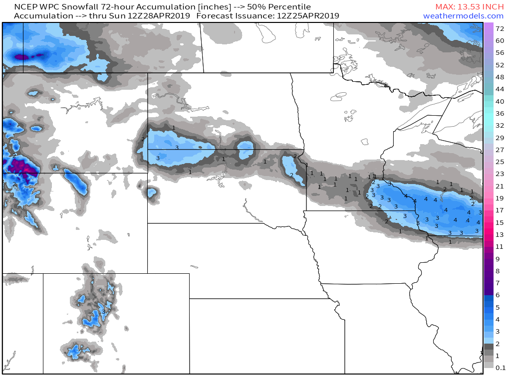
Featured Product: WPC Percentile Snowfall, available with any weathermodels.com subscription
Here’s the WPC’s middle of the road (50th percentile) snowfall forecast through Sunday morning. The general pattern will be higher totals where the snow falls at night, and lower totals where snow falls during the day (within the heavy band of course). Friday night, snow will be focused in SW ND and NW SD, where 2-4″ is expected. As the storm moves east on Saturday, less snow will fall over NE SD and SW MN as the snow will be fighting strong heating from the sun. Therefore only 1-3″ is expected. By the time you head east into SE MN, NE IA, and S WI, you’ll be seeing heavy snow during Saturday night, and thus totals will go back to the 2-4″ range. For snowfall forecasts specific to your town, head on over to weather.us and type your town into the search box.
My next update here will be on Monday where I’ll take a look at next week’s weather. In the meantime, follow us on twitter @WeatherdotUS, @RyanMaue, and @JackSillin for more frequent updates.
-Jack


