Wintry Weather Sets Its Sights on Texas For the Weekend
With our southern Appalachian snow event well underway this morning, we can now turn our eyes to the next weather-maker set to impact the south central US this weekend. Let’s take a look at what we know so far.
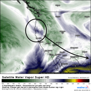
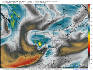
This area of vorticity currently coming ashore in the Pacific Northwest will dig south and east today and tomorrow. It, combined with a surface low that will form in the western Gulf, then brings the threat of snow to Texas (yes, Texas) Saturday and Sunday.
As we know from today’s event, any southern snow requires a few ingredients. Not having all three of those ingredients makes for a low confidence, high bust potential forecast. I write that with disappointment as I stare out my window and see cold rain instead of the forecast snow all because we are literally one degree warmer than we needed to be. But I digress…
Let’s see what ingredients we have for the upcoming weekend event.
Cold Air
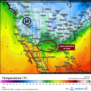
We have a strong high feeding air south. Unfortunately, there is no true arctic air attached to it. Temperatures near it are cold, mostly below freezing, but they are not frigid. The high is a decent distance away from the area in question as well so, once again, the air has a ways to travel and will modify as it moves south. Another problem: the antecedent air mass is warm. The mid 40s and low 50s in the areas we are watching for snow are going to require a lot of cooling to make that snow possible. We can always hope for some help in the form of dynamic cooling with a little assistance from rising air.
Moisture
As is usually the case with systems near the the Gulf, moisture won’t really be an issue. The system gets an assist from a surface low that forms in the western Gulf and funnels moisture north and west. Dry air on the southwest side may try to mix in a bit on the southern edge of the precip shield but, overall, plenty of moisture.
Weak Low
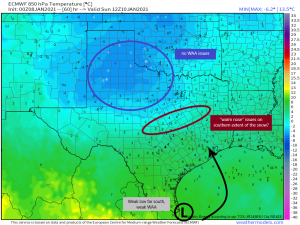
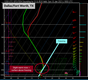
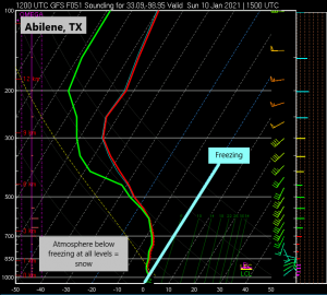
We will see a weak surface low form in the southwestern Gulf. This is key. First: the fact that it is so far south allows for the cold air to be pulled into Texas. Second: the weak nature of the low means that we won’t see strong warm air advection on the eastern side of the low. Any cold air coming into the area should be able to remain cold. It’s possible to see a brief warm nose in the areas on the southern extent of the rain/snow line that could allow for some mixing at first. In fact, let’s look at that.
So, for areas further north and west, such as Abilene, after initial mixing at the onset, the entire atmosphere cools below freezing, making the primary mode of precipitation snow. This is one of the areas where the highest totals will be seen.
However, for areas like Dallas and Fort Worth, temperatures will remain above, though just slightly, freezing. That, along with a slight warm nose thanks to weak WAA, means that mixed precip or just plan cold rain will fall here. Any real snow will likely come on the back side of the system as the moderately cold air rushes in.
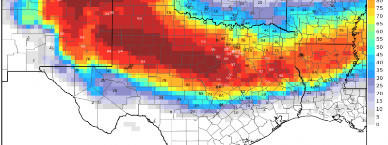
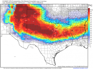
Probabilities reflect what we discussed above with the greatest likelihood of accumulating snow far northwest of the surface low, where the air will be colder. Accumulations further south will come on the back side as long as there is adequate moisture and cooling, hence the lesser chances.
Now, all that said, understand that since this is a southern event and there is no true arctic air incoming, temperatures will be borderline in many places throughout the duration. A little wiggle either way could dramatically change the outcome for any location. I’m speaking from experience this morning as we were expecting 2 to 5 inches here in the foothills of the Smokies. Unfortunately, thanks to a persistent warm layer a few hundred feet aloft and surface temperatures that are also just a hair too warm, we ended up with a cold rain. Such is the nature of southern snow storms. Unless the forecast is a slam dunk (meaning ALL THREE ingredients exist at the same time), there is a high bust potential. Keep that in mind and don’t go after your local meteorologist on social media if their forecast doesn’t pan out. These are often extremely difficult events to nail a forecast for.
We will keep you updated as the forecast changes throughout today and tomorrow.
Have a wonderful weekend!!


Thanks Meghan – great analysis