What To Expect When You’re Expecting Hurricane Ian
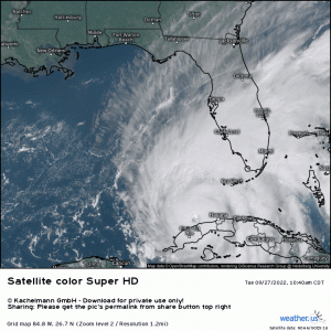
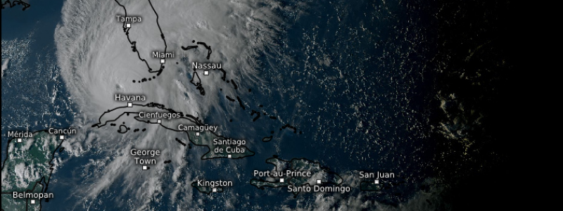
After trekking over the western part of Cuba earlier this morning, Hurricane Ian emerged into the Gulf relatively unscathed. Since then it has only deepened.
Ian is (as of 8 PM Eastern) a Category 3 hurricane with maximum sustained winds of 120 mph and a central pressure of 947 mb. It is expected to reach Category 4 status sometime soon.
Hurricane categories are good attention-grabbers. I mean, if you say you survived a category 5 hurricane, that would be pretty impressive, right? Sure, but the Saffir-Simpson scale measures wind speeds only. And these maximum wind speeds are only found within the (sometimes small) eyewall of the hurricane. It completely overlooks the severity of other hazards – such as the water component of a hurricane.
This blog will focus on the impacts expected as Ian nears western Florida. This includes rainfall, storm surge, and, yes, wind. Let’s see what we’re dealing with.
Rainfall
Tropical cyclones obviously have access to deep moisture and almost always bring heavy, sometimes flooding, rains to the region they track over. Ian will be no different, however, a change in forward speed as Ian approaches land, along with interaction with a cold front draped over the southeast, will allow for a serious freshwater flooding threat.
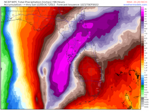
Ian’s forward speed will slow significantly on approach to Florida. So, instead of landfall-and-gone, it will crawl toward the coast over a period of at least 24 hours, inundating the peninsula as it goes.
This map suggests the heaviest rain will be found along and north of the center. Exact location of that rainfall will depend on where the eye comes ashore – something we’ll discuss shortly. But as the forecast stands now, there’s a very real possibility that places like the Tampa Bay area, Orlando, and across the peninsula to St. Augustine could see nearly 20 inches of rainfall before it’s all said and done.
This forecast screams significant freshwater flooding. Rivers will flood, roads may become impassable.
Unlike places like New Orleans, most if not all of Florida is above sea level. This means that rainfall will seek to “run off” and return to the sea. That’s a problem if storm surge is occurring. It could potentially enhance storm surge heights.
If you live in a location in line for the heaviest rains, plan ahead. Sandbag your home, or, if you’re particularly prone to flash flooding not related to storm surge, consider evacuating. If these forecasted totals verify, we will see some very serious flooding issues.
Surge
The other water component of a hurricane, one that is arguably the most dangerous, is storm surge.
Storm surge occurs when wind pushes the water from an ocean, bay, or lake toward the shore, forcing it out of its banks and flooding the surrounding area. As if the power of moving water isn’t enough, surge is often accompanied by large, destructive waves – especially in stronger hurricanes.
Storm surge is always at its worst to the right of the eye, where the onshore flow is strongest. The onshore push can be enhanced by the underwater topography of the continental shelf and the shape of any bays or inlets.
Unfortunately, the continental shelf leading up to Florida’s west coast is long and gently sloping, allowing water to pile up easily. In addition, Florida features many bays and inlets.
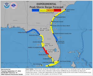
The location of the highest surge will be highly dependent on where the eye tracks and comes ashore. Little wiggles in track now, while still at sea, can have big effects later on. A small wiggle to the east or west may mean the difference between the highest surge being experienced in the Cape Coral/Punta Gorda area versus the Tampa Bay area.
For now, the eye seems poised to come ashore south of Tampa Bay, leaving them on the side with offshore flow and less surge. In this case, Cape Coral/Punta Gorda will receive the strongest onshore flow and the highest surge.
As mentioned above, wiggles in track can cause this to change. It is very important to stay up to date with the most current forecast. In addition, if you’re near the coast and told to evacuate and you are able to go, please go. Could the worst surge move away from your location? Sure, but what if it doesn’t?
Wind
Ian is currently forecast to come ashore as a category 3 hurricane. In that case, winds of up to 125 mph with higher gusts will be possible in the eyewall. How large the wind field becomes as Ian slows and whether or not Ian undergoes an eyewall replacement cycle (which also expands the wind field) will determine how far out tropical storm force/lower-grade hurricane force winds extend.
There is evidence that Ian may in fact be undergoing an eyewall replacement cycle this evening. While that will temporarily halt intensification, it will, as stated above, expand the wind field. That’s not great news in terms of damaging winds and the extent of maximum storm surge.
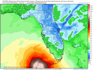
Here is an idea of potential maximum gusts based on the current track/intensity forecast from the ECMWF. Use it as a guideline only, not gospel truth. And keep in mind that other models show a larger wind field while others maintain a smaller wind field.
In this model, the stronger winds begin arriving Wednesday morning, increase through the day, and finally exit on Thursday. It’s a reasonable timeline and fits with what we talked about: Ian’s forward speed will slow, resulting in prolonged exposure to it’s impacts.
Now, add any of these wind speeds to the rainfall I mentioned above. Soggy ground plus gusty winds equals widespread power outages. Be prepared to go days without power if you are not evacuating.
Severe Weather
It’s not uncommon to see tornadoes spin up along the eastern/northeastern quadrant of Hurricanes as some research has been shown, and hurricanes add favorable “ingredients” to the atmospheric environment. It basically “primes” the environment via moisture and instability, not to mention the kinematic profile (i.e. forces of the winds).
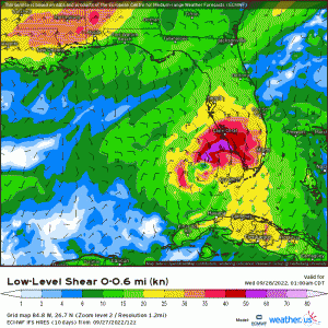
The eastern side of Ian will provide strong deep vertical wind shear, on top of an already moisture-rich environment with instability (CAPE), making it favorable for tornadoes. What’s more, supercells coming off the ocean via Ian will rotate toward land already having favorable dynamics to work with, and once friction becomes a factor as storms interact with land, tornadoes can spawn quickly.
Below displays 0-6km vertical wind shear, which again shear organizes storms and plays a critical role in tornadogenesis. Verbatim, the hi-res ECMWF shows values exceeding 40 knots easily, and typically supercells are much more likely with values between 30-40 knots. As you can see, there will be no shortage of wind shear values as we can see greater than 50 knots given the added “boost” from Ian.
On top of already life-threatening hazards, concerns regarding severe weather aspect exacerbate the compounding effects of what Ian will bring. It’s why evacuations and proactive preparations are an absolute must!
Stay tuned to our Twitter feeds as we’ll be keeping information flowing throughout the day tomorrow as we lead up to landfall!
Stay safe, folks.
