Two Disturbances, Two Severe Threats
The return of spring-like temperatures this week has been fast and furious. The sudden warmth, blue skies, and blooming flowers no doubt set the spring mood – and may have some longing for thunderstorms.
If you’re one of them, this weekend is for you. But beware, those thunderstorms could become severe.
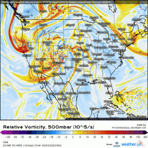
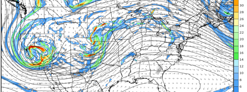
Two separate shortwaves will eject northeastward across the Plains states along the western periphery of a ridge. The first is expected Saturday while the second is expected late Sunday. Each will affect a different area.
Saturday
This particular threat is perhaps a bit further north than you might expect, at least when you think of the average spring-time severe event. And that fact may hinder its potential just a bit.
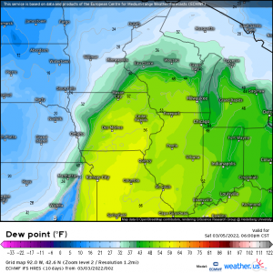
A deepening low will pull moisture northward into Iowa, Missouri, Illinois, and even Wisconsin. The resulting dewpoints should be enough to facilitate a severe threat – though perhaps just barely.
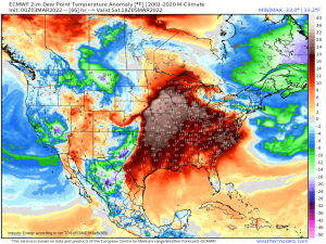
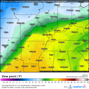
I mentioned the strangeness of the location for this event relative to the time of year. Using the map above, we see why. Dewpoints, though marginal for severe weather, are forecast to be well (25 to 30 degrees +) above what is “normal” at this time.
Due to the limited moisture/instability, this event could struggle to produce and will likely rely heavily on the lifting provided by the front.
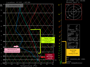
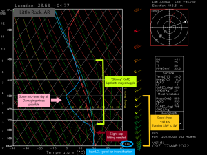
By checking out a forecasted sounding, we can determine a few things.
- There is adequate shear. Should storms be able to strengthen in the first place, there is enough shear to sustain supercells and/or produce a tornado or two.
- “Skinny” CAPE (lack of instability) means updrafts may struggle to accelerate, keeping storms from strengthening much.
- There is a low level inversion, or cap. Temperature increases with height here and we will need a lifting mechanism (the front) or increased instability to break it.
- There is a decent amount of mid-level dry air. This assists in the formation of downdrafts and presents a damaging wind threat. Winds in this “dry layer” are ~55 kts. These are the speeds that can translate to the surface in a downburst.
Based on what the sounding tells us, we certainly have potential for severe storms, but the limited moisture and therefore limited instability may mean that this event struggles to produce. We are still over 48 hours out, so things can change – either in favor of a stronger event or a weaker one. We’ll monitor the trends and revisit it Saturday morning.
Sunday
Simply by looking at the location (closer to the Gulf) for Sunday’s event, we can assume conditions should be a little more favorable for severe weather, at least in terms of thermodynamics.
And it’s true, we are expecting more moisture/instability in the form of higher dewpoints, however, this will be a nighttime event. Without the possibility of added instability through daytime heating, we’ll rely on lifting and shear to get things going, so to speak.
This then becomes a High Shear, Low CAPE (HSLC) event. These events can be tricky. Sometimes they don’t produce much. Sometimes they produce more than expected. Let’s look at a forecasted sounding:
We have:
- Good shear on the order of roughly 45 knots. Enough to sustain supercells. Winds also turn decently with height, allowing for tornadoes.
- “Skinny” CAPE could hinder strengthening as updrafts struggle to accelerate.
- Slight cap. Some extra lift or added instability will be needed to break it.
- Decent dry air in the mid-levels can facilitate a damaging wind threat
- Something we didn’t see for Saturday – Low LCLs. Parcels won’t have to be lifted very far before being accelerated into the atmosphere. Low LCLs are common in the moisture-rich environment closer to the Gulf
- Unlike Saturday’s event, there is a lack of cold air aloft and therefore lapse rates aren’t the best. Updrafts may struggle to strengthen.
Overall, this isn’t a perfect set up for severe weather. Far from it, really. However, a lot of shear can overcome a lack of instability.
We are also still roughly 3 days out. If the moisture increases in forecasts going forward, that can change the available instability. The same can be said if it decreases. We’ll revisit this set-up on Saturday as well.
Since a lot can change in 2 to 3 days, especially as more mesoscale details come into focus, for now just know that there is the threat of severe weather Saturday and Sunday. Sunday’s is expected to be overnight, continuing into Monday morning so start preparing if you’re in the risk area.
As I said above, we’ll revisit these threats in a blog on Saturday morning and see what has changed, if anything, and what we’re expecting.
