Tropical Depression 7: It’s Complicated
Our sluggish hurricane season limps onward as we now have Tropical Depression 7 in the Central Atlantic.
TD7 managed to pull enough convection together during the diurnal maximum, despite being nearly bare of convection yesterday, to be classified as a depression earlier this morning.
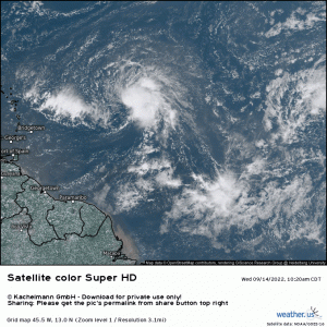
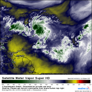
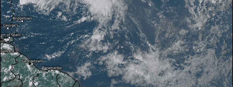
Looking at the satellite imagery, a few things should grab our attention immediately.
- The environment around TD7 is exceedingly dry. If dry air intrudes into the circulation, TD7 is going to struggle. Seems to be the theme this year.
- TD7 is fighting some northwesterly shear. The low level circulation is clearly visible, but all the convection is blown to the ESE side of the depression.
- Due to the factors mentioned above, TD7 has been unable to wrap convection around the entire circulation. It needs to do this to strengthen.
Based on the above factors, we get the idea that this forecast is certainly not a slam dunk. And, we haven’t even talked about problems with the track yet.
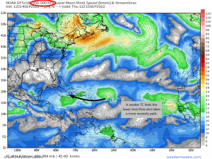
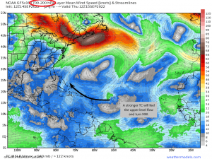
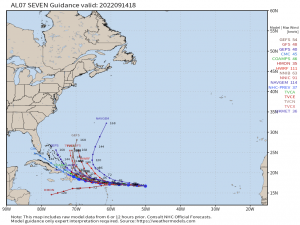
As mentioned, TD7 will be fighting shear and dry air in the short term while it attempts to intensify. The extent of its future intensity will have an important impact on the track. Why? Because storms of different intensities (i.e.: weak vs stronger) “feel” the flow from different levels.
A weaker TC will feel the mid/lower level flow better, causing it to take a more westerly path into the islands of the Caribbean. A stronger TC would feel the mid to upper level flow better, causing it to turn northwest, potentially avoiding some of the eastern Caribbean islands.
The official forecast from the NHC suggests a more westerly path for now. That would mean a weaker storm which, based on the shear and dry air present, is a likely scenario. Still, its not set in stone.
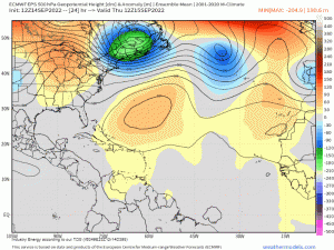
Also, steering winds aren’t the only thing we need to factor in here. We also need to look at the synoptic-scale features that will influence the position of our TC-to-be.
You might want to run that loop a few times. There’s quite a bit in play here.
Let me tell you what I see:
- The Bermuda High is currently in control in the Central Atlantic, keeping TD7 on a westerly course as it can literally go nowhere else. However, that high is forecast to retreat eastward.
- Questions we need to ask:
- How quickly does it retreat?
- How far will it retreat?
- Is whatever TD7 becomes moving too fast or too slow to take advantage of the high retreating?
- Questions we need to ask:
- As the Bermuda High gets ready to retreat eastward, it weakens. At the same time, a ridge builds over the Eastern US.
- Will TD7 “feel” this weakness and turn, slipping between the gap in the ridges? A stronger TC probably would, hence the northwest turn on the maps above. A weaker TC may not.
- How will the East Coast ridge affect TD7’s path down the line? This depends greatly on the answer to the questions above, but also on one more thing: TD7 surviving that long.
Let’s say TD7 remains weak and takes the forecast westerly path.
At some point, it will likely have to interact with the mountainous terrain of Hispaniola. This particular island has a maximum elevation of 10,164 ft (Pico Duarte). Elevations like that can really do a number on tropical cyclones. In fact, Hispaniola has a long history of shredding TCs.
It’s completely possible that TD7 survives the dry air and the shear just to be gutted over the island.
So, as you can see, there are many, many unknowns and factors at play in this forecast. Anyone who claims to know the final destination of TD7 and whether or not it will impact the US in any way needs to re-examine their forecasting skills. This will be a changing forecast in the coming days, but it is most certainly one to monitor. We’ll watch the trends and keep you updated here and on Twitter.
For now, the Leeward Islands are up first in the way of impacts. Heavy rain and gusty winds can be expected at the very least. The islands west-northwest should monitor the forecast in the next few days.
