The Month of August: What Can We Expect Pattern-Wise?
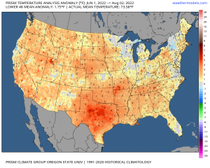
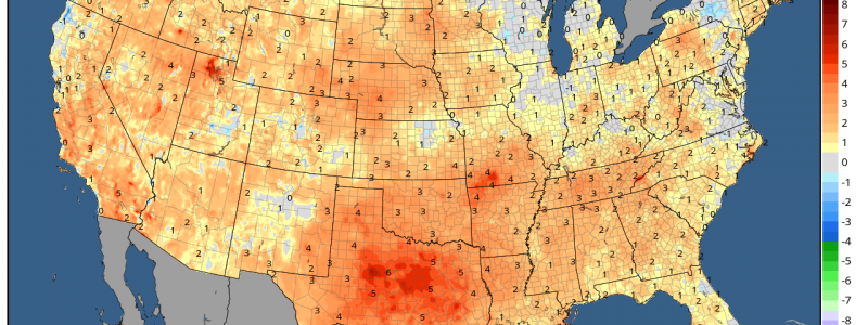
Summer is flying by; I mean, meteorological fall is less than a month away and the astronomical season of fall is literally next month. It’s been a rather warm and hot summer for the Central part of the U.S., covering the majority of the Northwest, Great Plains, and the Deep South while seeping into the Southeastern states. Since June 1st, above average temperatures have covered these aforementioned places with the mean average temperature several degrees above climatology for general areas with the notable exception across the Great Lakes and interior Northeast.
For those that live in those regions, it probably has felt like months that this pattern has just remained stagnate. You’d certainly be correct because that’s actually been reality since the beginning of summer. What can we expect going forward through the rest of August?
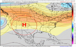
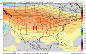
Take a look at both the ECMWF EPS and GEPS (Canadian Ensembles) that average every five days of the upper-level, 500mb height pattern. Utilizing the mid-levels of the atmosphere helps give a sense of what the sensible weather will be down below in the lower part of the troposphere. Ensembles, unlike deterministic models, essentially are used to help give us a range of possible outcomes and likelihood of their occurrence because ensembles are made up of single individual members that are “perturbed”. This means that each member takes initial conditions and perturbs those conditions to see how future outcomes may pan out. If we see a majority of these members, when taken collectively, agree on a certain pattern that looks the same, this implies greater confidence. However, just because a model in particular or an ensemble shows higher confidence doesn’t necessarily mean it’ll be 100% correct. That’s where we can use analogs or other “signals” in the atmosphere that can help supplement model forecasts and approach it from a different angle! I’ve annotated to point out the progression in five-day increments:
- The Sonoran ridge (gets its name from forming across the Desert Southwest during the summer months) will likely retrograde slightly toward the Intermountain west and along the Rockies, after meandering across the Central U.S. and Midwest.
- By mid-month, lower-than average 500mb heights, or a trough, will impose across the Great Lakes and Northeast. This sets up a more active pattern since shortwaves and disturbances can “ride the ridge” in a Northwest flow, and clash with the moisture and higher humidity induced by the Bermuda Ridge along the Eastern Seaboard.
- By the end of the month, there is a solid consensus that we see this subtropical ridge pull back even further west and set up across the Pacific Northwest, with troughing allocating into the Midwest and bleeding into the Mid-Atlantic. Upper-level heights via the Bermuda ridge may usher above average temperatures across the Northeast and east of the Appalachian Mountains.
Predicability and skillful forecasts trend down pretty significantly past about two weeks, but at least we can garner a sense of what the pattern may be like at longer lead times thanks to reasons mentioned above, and also it does help that we’re still in the season of summer meaning forecasts are statistically better. This makes sense just because we have less instability between the poles and the equator, where the changes in seasons “fight” as one season is being replaced by another. In summer, we mainly see quasi-stationary patterns as these large sub-tropical ridges circumnavigate the Northern Hemisphere during the summer, making it relatively easier to forecast.
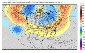
Here is the CFSv2 (a climate model used for medium to long range forecasting) displaying what is a weekly 500mb prognostication. If you compare the CFSv2 and the ensembles mentioned, we see solid agreement on the evolution of the mid-level pattern through the month.
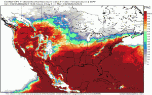
We can also infer where the mean mid-level ridging, or sub-tropical ridge, will stagnate for a bit heading deeper into August through temperature probabilities. This shows where there is a greater probability of seeing surface temperatures greater than 80*F. Notice how you can outline where the ridge will be, in which that’s exactly what I did. On the contrary, notice the lack of higher probability east of the Appalachians – especially the Northeast.
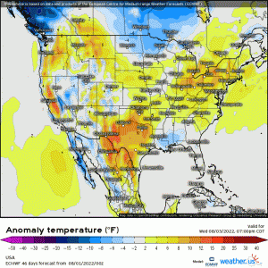
Using the EPS temperature anomaly, we can also see where above average temperatures are likely to prevail and with no surprise, we see where the majority of those warmer than normal conditions will take place. Some more heatwaves are likely to manifest across these areas that have continuously seen them.
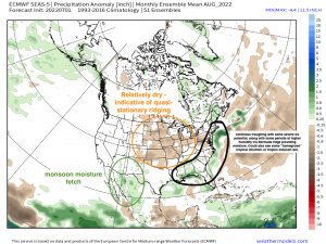
Lastly, I’ve annotated the ECMWF seasonal model that displays a precipitation anomaly “snapshot” for the month of August. Few things I’ve pointed out that’d be seen with what type of pattern progression is expected during the next few weeks:
- Quasi-stationary ridging across the Great Plains and along the Rockies supports relatively dry conditions, consistent with dynamic subsidence, or sinking motion, associated with the mid-level ridge that’ll meander across the Central U.S. through mid-month and slowly retrogress westward.
- Monsoon-induced moisture fetch emanating from the Gulf of California providing continuous thunderstorms and heavy rainfall for the desert Southwestern states.
- East coast activity – from the Gulf up to Maine will see periods of below-average temperatures, but active storm patterns induced by the troughiness that’ll settle across the Northeast and Great Lakes this month. I also would like to add that this total precipitation forecast implies potentially “homegrown” and tropical-induced precipitation that’ll bear watching as we trek deeper into Hurricane season, annotated in black outline.
So if you’re a fan of summer-time convection, heat, and humidity; enjoy it while it lasts because we still have several weeks left for summer activities and enjoyment (like me!). On the flip side, soon enough we’ll be seeing those strong late summer and early fall cold fronts, reminding us that fall isn’t to far away, and is approaching our horizon swiftly!
