The Latest on The Impending Impactful Pre-Christmas System
A strong, dynamic system will begin to impact the Midwest and into the Great Lakes, before spreading eastward regarding multi-faceted impacts and hazards. Updating from Meghan’s blog, this is what we’re looking at from a general standpoint, and then will zero in on each region that’ll see large impacts from this cyclone.
Over the next 24 – 30 hours, as our longwave trough digs and strengthens with cold air advection upstream with warm air advection downstream – increasing baroclinicity and the surface pressure gradient – will undergo rapid cyclogenesis. A drop in over 24 millibars in (25 – 30mb) in 24 hours qualifies for “bombogenesis”, with rapidly evolving dynamics involved as our trough tilts into a negative position (i.e. tilt axis oriented NW to SE), and downstream is where we see upper-level divergence and diffluence are maximized. We can visualize this through mid-level z500mb relative vorticity, as our trough digs, tilts into a negative position, and “bowls” its way into the Northeast. As it does so, several meteorological processes manifest:
- DCVA (differential cyclonic vorticity advection) increases with height downstream the trough axis.
- Differential thermal advection with height (warm air) increases as cold air advection increases also with height upstream, therefore, generating a strengthening trough
- Large scale surface response through ageostrophic processes (i.e. imbalance in wind, therefore causes an acceleration to compensate for mass loss at the surface) yields strong surface convergence.
- Upper level divergence through the left-exit of the jet streak enhances surface convergence, and yields a strong latent heat response causing further deepening of the surface low. We also as a result, see diffluence (winds spreading apart indicative of mass upper level divergence).
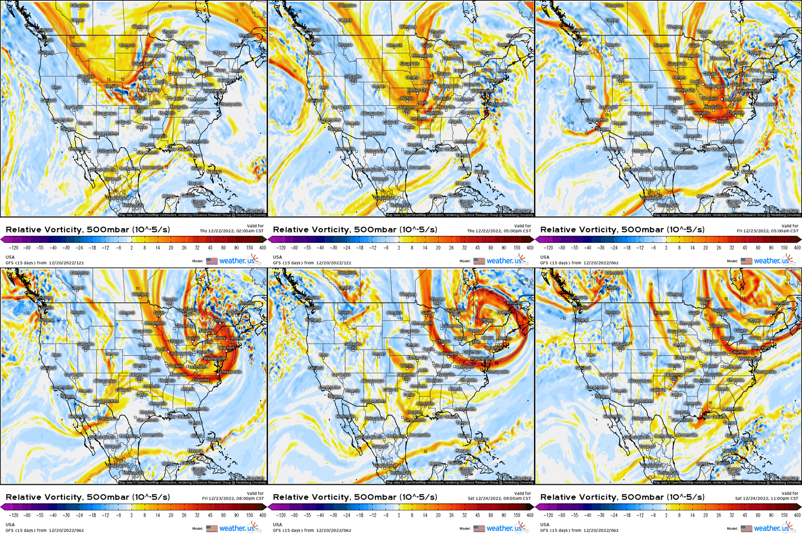
At the surface, a ~1008mb low will track from southeast MO, southern IL, into IN, and into MI by tomorrow before we may even see a new low try to develop along the arctic front along the NY/CA border! That’s how dynamic this system is. The main surface low, however, will venture across the upper Midwest and into Michigan, strengthening to a sub 978mb low by tomorrow afternoon, which again, undergoes rapid intensification with blizzard conditions on the north and west side of the low with heavy rain out ahead, south, and east of the low’s track.
Midwest/Great Lakes Impacts:
- 2 – 5’’+ (, locally 6-12”+ with areas seeing over a foot) swath of snow from central-northern IL (Chicago metro), central-eastern IA, southeast MN, WI, and into northwestern-central MI.
- 1-3’+ across the UP of Michigan into northwestern MI, and upstate NY surrounding the Buffalo area (all lake effect).
- 2-4’’+ swath of snow across central-western IN, with over an inch further along I-70 into Ohio.
- Damaging wind gusts of 35 – 50 mph+ starting later today and into tonight from IA, southeastern MN, MO into IL & IN, before shifting eastward by tomorrow across the Ohio Valley. This is going to be the most dangerous part of this entire cyclone since it’ll cause significant blowing & drifting of the snow!
- Dangerous blowing and drifting conditions making for significant reduced visibilities, especially with 1-2′ per hour rates.
- Infrastructure issues with the combination of heavy snowfall & strong winds, along with widespread power outages! This will make for an even more dangerous setup given the dangerous arctic air moving in behind the system!
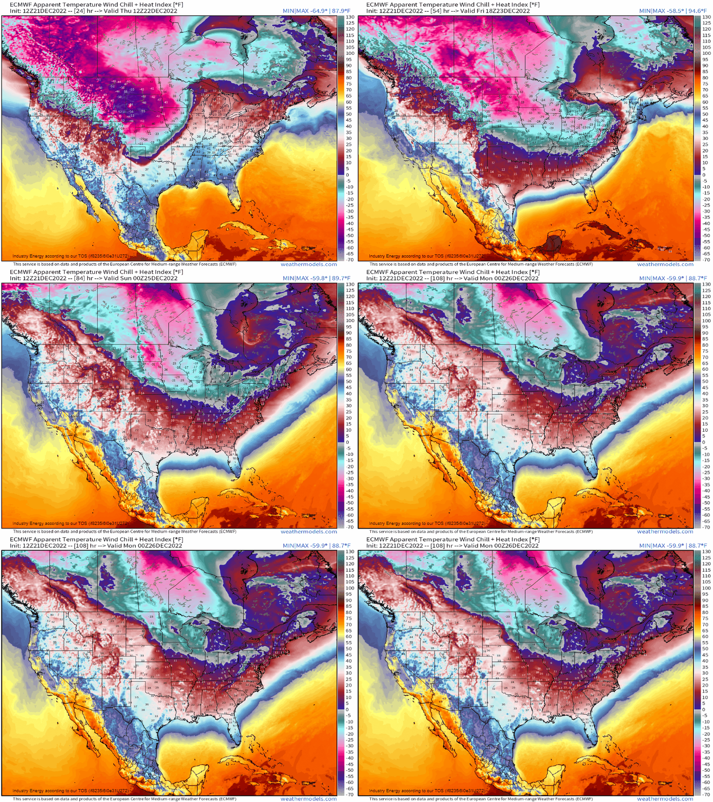
- Dangerously sharp drop in temperatures with subzero lows and wind chills into the teens, 20’s, and even 30’s through Sunday! This calls for winter weather preparations as pipes are highly subjective to freezing, as well as any other prone wet areas subjective to flash-freezing with temperatures dropping over 20 – 30 degrees in a matter of several hours later tonight and into tomorrow. Also keep in mind pets & plants!
- Steady winds abate by Saturday; however, bitterly cold temperatures remain through Christmas weekend with average temperatures in the single digits and teens, especially where there is snow cover. Subzero low’s expected through Monday morning, with the coldest nights being tomorrow night and Saturday night.
Northeast:
- 3’’+ for the Blue ridge & Allegheny mountains on the front end, with some sleet and potential ice; however, this quickly goes over to rain. Some snow will make it up into western-northern PA this afternoon producing possibly a few inches, before quickly getting washed away.
- Widespread heavy rainfall of 0.5’’ – 2’’+ across the Mid-Atlantic and Northeast through Saturday with the heaviest transpiring tonight and into tomorrow night from southwest to northeast (up entire I-95 corridor).
- Flooding issues with heavy rainfall over antecedent snowpack. Rivers and streams most especially prone, along with poor-drainage areas (urban especially).
- Coastal flooding along from the Delmarva up to the NJ coast, especially if coincides around peak high tide and with the new full moon.
- A 20 – 30 degree drop in the matter of a few hours post arctic front tomorrow into Saturday, bringing about bitterly cold temperatures into the teens (interior) to 20’s for highs through Sunday with lows in the single digits and teens. Sub-zero wind chills following the front, which will clear the east coast by midnight tomorrow.
- Flash-freeze potential with any wet surfaces becoming frozen, although the one silver-lining is that because of the strong pressure gradient, winds help to maintain a mixed boundary layer therefore helping with evaporation. Still, any pipes or any sensitive materials subject to freezing will definitely experience issues given the anomalous drop-off In temperatures. Also don’t forget any pets & any outdoor plants exposed need proper care accordingly!
- Wind gusts in excess of 30 mph+, and gradually easing into Sunday.
- Likely power outages from the sustained wind gusts, especially over 40-50mph+ and the concern for no power amidst stretch of very cold days – especially around a major holiday!
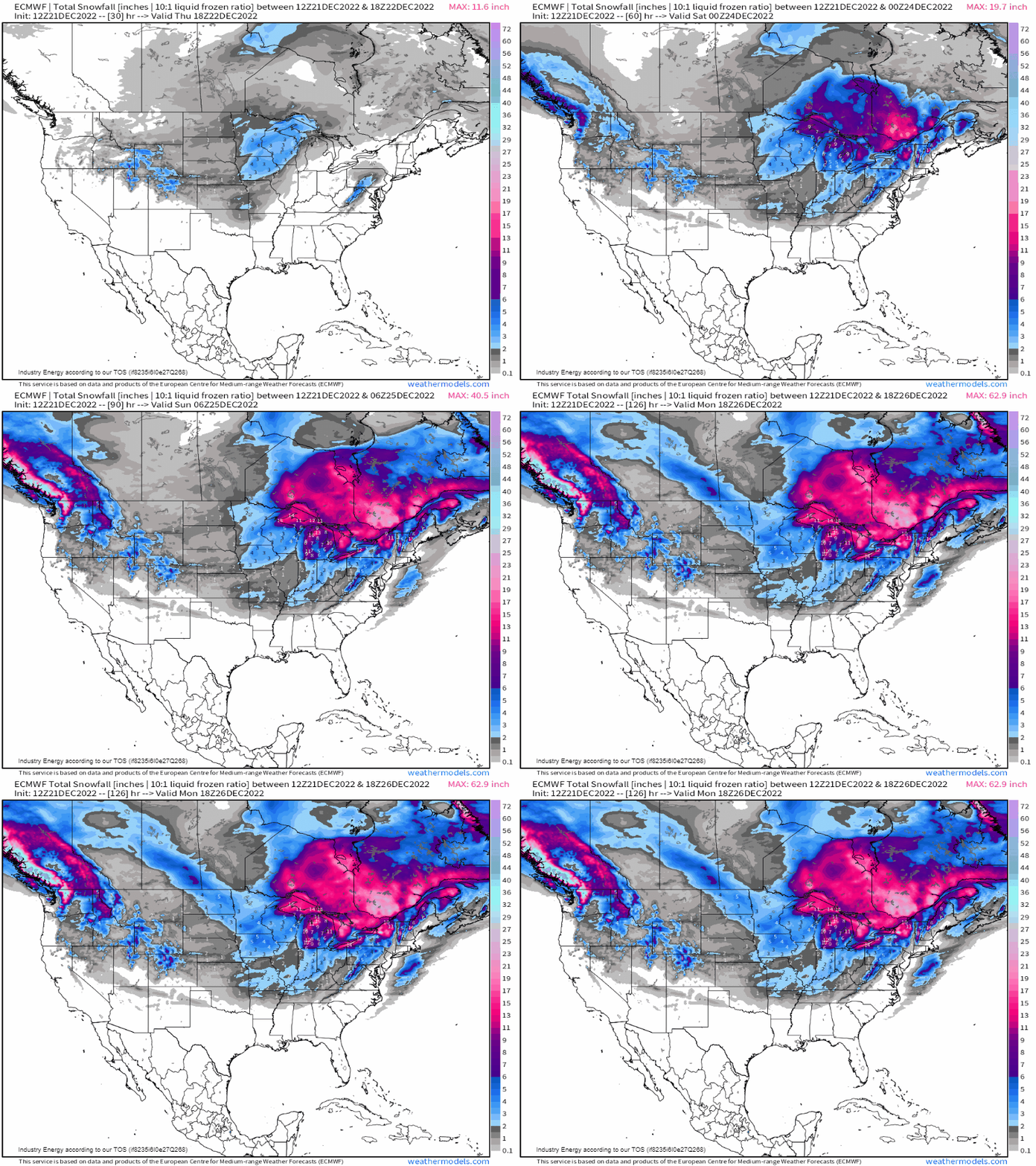
Snow totals through early next week, along with more significant snowfall for the Pacific NW including Washington where a significant ice storm will look to occur tomorrow! Other areas, we can see the general corridors of snow fall, with the heaviest zeroing in on the Great Lakes as the Lake-Effect goes into full swing!
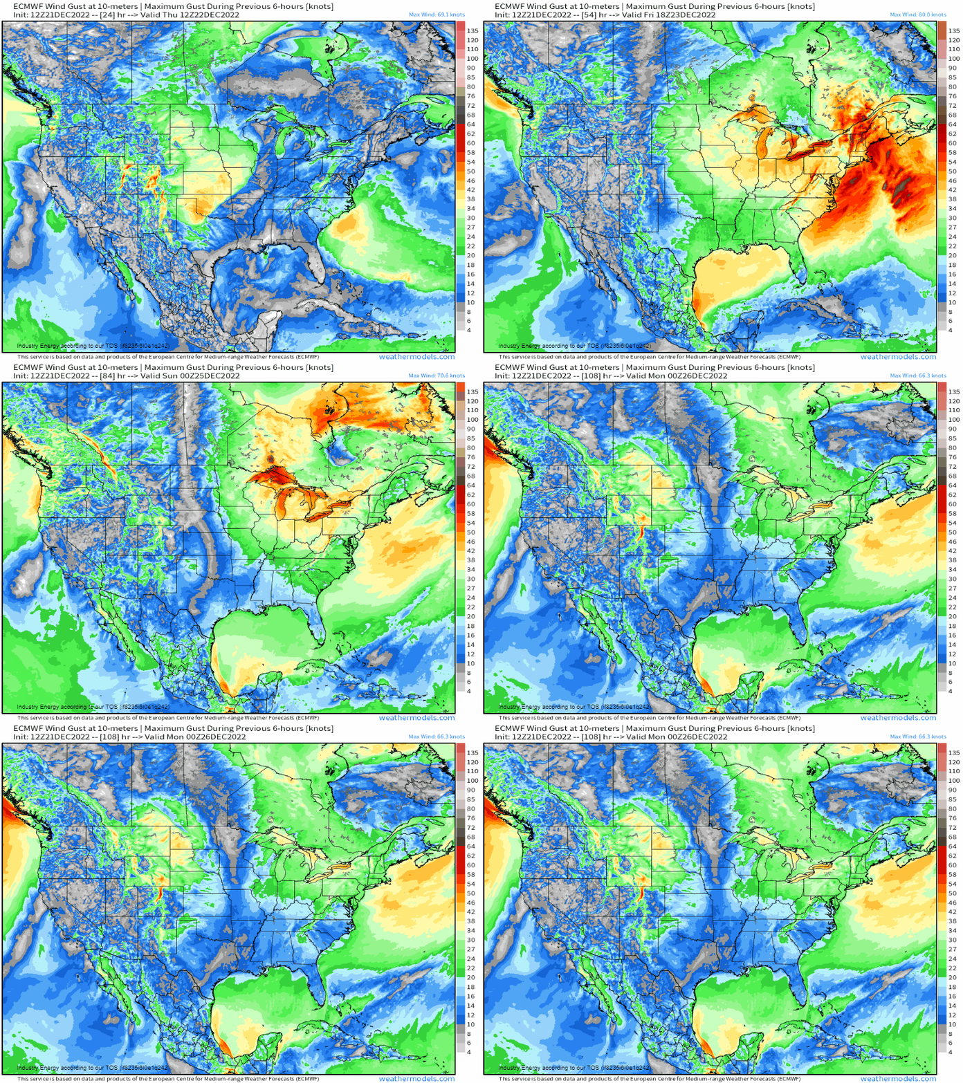
Then we see the widespread very strong to damaging wind gusts in the wake of the powerful arctic front and strong system as it wraps up and heads into southern Canada.
Lastly, lets not forget the incredible declining temperatures behind this powerful arctic front, as wind chills will be 30 to even near 50 degrees below zero across the northern Plains and upper Midwest, while 5 – 15 degrees below zero further southeast across the Great Lakes and Northeast. Elsewhere, wind chills will get to near or below freezing through the holiday weekend, and this includes along the entire South from TX to FL.
Prepare for major travel delays and disruptions across these regions as this highly dynamic system spins for a few days, while it’ll bring about the most disruptive impacts initially. It’ll also still linger through early next week with snow showers and winds before it finally ejects further away, so the pressure gradient will abate as we head into next week. If traveling, hopefully you’ve found an alternate route into this part of the country. Regardless, prepare for heavy snow, very strong winds, and dramatic temperature swings with dangerous arctic air moving in just in time for Christmas weekend!
Stay safe!


