The Big Chill
Good afternoon! I hope everyone had a relaxing, tasty, and safe Thanksgiving.
Well, meteorological winter officially begins on December 1st and the atmosphere has decided to celebrate in a big way this year.
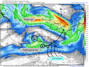
Over the weekend, a cut-off low currently over the desert southwest will merge with a low coming out of the Gulf to bring a system to the eastern third of the United States.
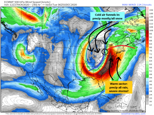
A split jet stream with a relatively strong southern branch (subtropical jet) will provide plenty of moisture for a mixed bag of precipitation as the system slides northeast early next week. Initially, the precipitation will come in the form of rain. As the system gains latitude, it will merge with the polar jet. The upper level low will then funnel some truly frigid air into the cold sector of the system.
Thanks to the assist from the subtropical jet, this system will have plenty of moisture to work with and a rather large precipitation shield which sets the stage for snow (yes! snow!) behind the cold front. I also need to mention the chance for severe storms in the warm sector of the system if day time heating allows for enough instability to develop. The current hazard is mainly damaging winds but a few tornadoes can’t be ruled out if enough instability is present. Jacob will keep you up to date on the developing situation in his blogs over the weekend as we get closer to the event.
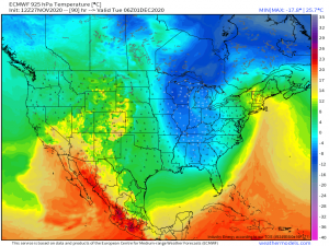
As the super cold air aloft sinks, we change over to snow from north to south. Higher latitudes will see the change faster so most of the accumulating snow will be concentrated across the Ohio Valley. The Appalachians, especially the high elevations, also stand to see some accumulating snow. Higher elevations = colder temperatures.
The map above is the temperatures (in Celsius) for the 925 mb pressure level. If you recall from my blog on inversions, 925 mb = around 2500 ft. Temperatures at that height will be a good bit below freezing in the southern Appalachians (the Smokies, even the mountains of West Virginia) so the change over to snow will happen faster there than at the surface and therefore offer a better chance of accumulation.
Temperatures in the valleys will plummet as well but perhaps not fast enough to allow snow to pile up.
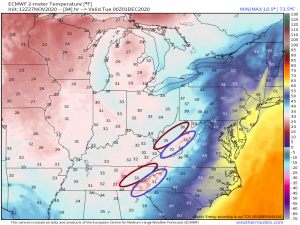
The above map is forecasted temperatures for Monday night. While the temperature is obviously falling, it’s falling much faster in the mountains (blue circles) than the valleys (red circles). The valleys will likely see rain change over to a wet snow at some point but, as I said earlier, not fast enough for accumulation.
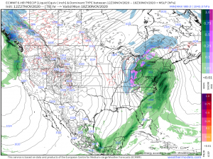
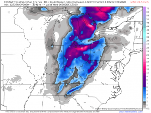
A quick look at the current accumulation forecast…
…more or less reinforces what I’ve written so far. Heavier totals will be north over the Ohio Valley. Places like western New York and northwestern PA could see some enhanced totals as well as the winds change to a northwest flow behind the front and trigger lake effect snow. Totals diminish the further south we go with the exception of the WV mountains and the Smokies which could each pick up a few inches in the highest elevations. The plateau area in middle Tennessee could also see comparably higher accumulation than the rest of the state due to it’s elevation.
Personally, I’m really hoping the mountain snow pans out. I may actually be mentally planning my photography route as I write this.
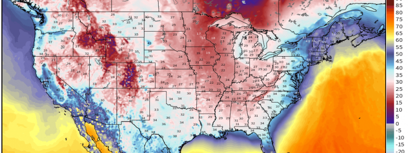
Beyond all this talk of snow, the bigger story here will be the cold.
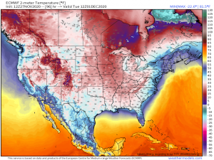
By Tuesday morning, we will be seeing lows in the 20s all the way down into the deep south. Even most of Florida (except the Keys) dips into at least the 50s. It looks like the entire eastern half of the country will feel this one. The extreme cold won’t be very long-lived. Temperatures will rebound a bit by the latter half of the week. However, there looks to be a couple more shots of arctic air in our future in the long range forecast. We’ll have to see if it pans out.
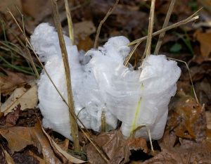
The cold weather won’t bring snow for everyone, as we talked about earlier. But if you’re feeling left out, places that haven’t previously seen a freeze may still find some beauty in the cold weather in the form of a frost flower.
“What’s a frost flower?” you may be wondering.
First of all, for a frost flower to form, the ground must not yet be frozen or have experienced any sort of deep freeze. As the moisture inside the stems of the plants freezes, it expands, which splits the stems open in long, thin cracks. Capillary action then draws the water through the cracks which freezes upon contact with the air. More water is drawn through the stem and exits the plant in long, very thin, very delicate “petals,” creating the illusion of a semi-translucent flower. Sunshine causes them to sublimate (turn from ice to vapor) so if you’re interested in seeing one, get out nice and early and take a walk. Frost flowers most commonly form on ironweed and crownbeard (frostweed) but have also been seen on fallen branches of conifers.
Now everyone in the south that won’t see snow has something new to look forward to finding early on Tuesday morning, assuming you enjoy the cold weather. Please share photos with us if you happen to find one! I would love to see them.
Stay tuned to our blog and Twitter for updates on the incoming system and other weather tidbits.
Have a great weekend, everyone!!
***Special thanks to Meteorologist Ben Cathey of WVLT in Knoxville for the idea for the Frost Flower feature!!
