
Subtropical Storm Nicole: What To Expect
When you think of November weather, I’d be willing to bet that tropical cyclones aren’t normally on the top of your “most likely to occur” list. Nevertheless, hurricane season runs through the end of November and we are, in fact, eyeing a disturbance.
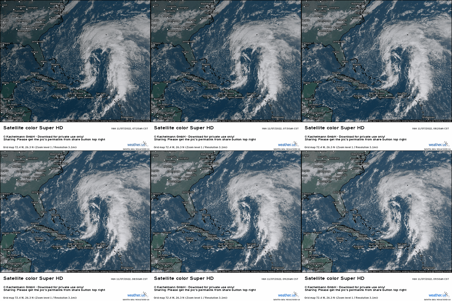
I know what you’re thinking because I thought it too: That looks like an absolute mess.
It’s a sub-tropical storm. Sub-tropical storms are cold-core systems that have tropical characteristics. Despite the mess, we can clearly see a defined center a couple hundred miles east of Nassau.
Quick intensification is not favored for what is now STS Nicole. Its sprawling nature isn’t conducive to intensification.
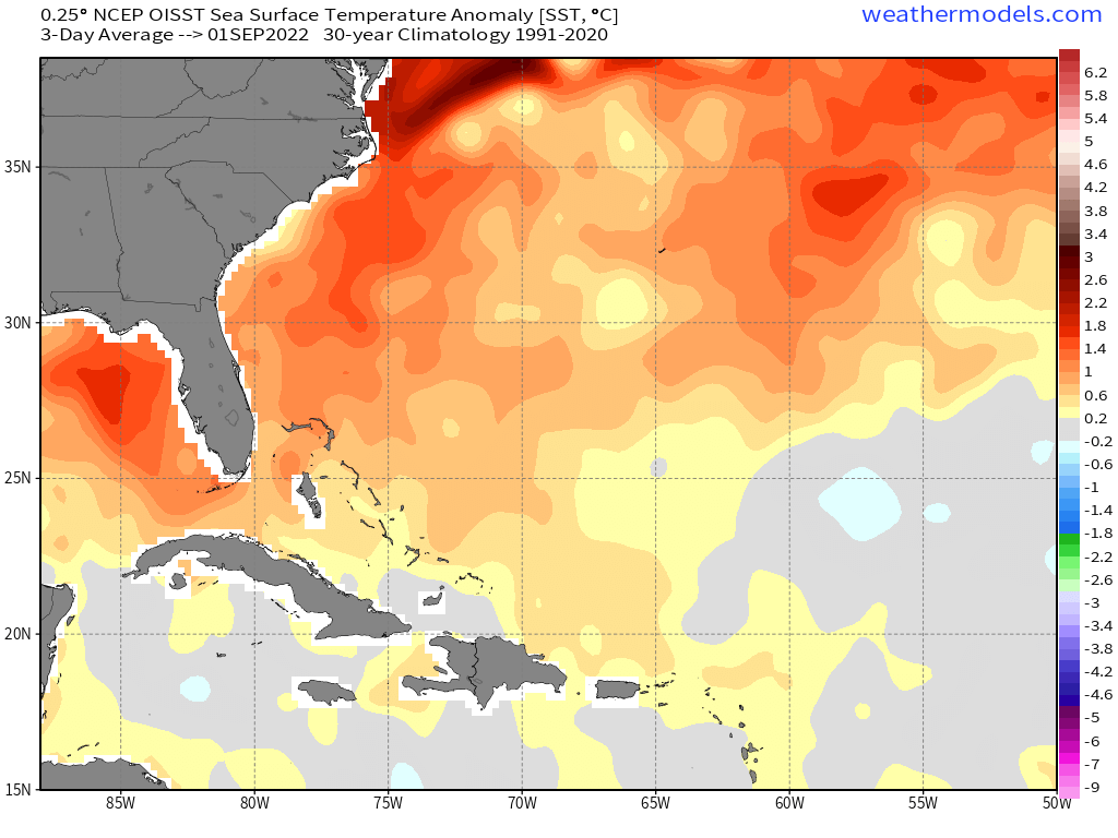
However, as it tracks north and west over waters much warmer than average for this time of year, it is possible that it could increase its central thunderstorm activity and develop into a warm-core system – or a purely tropical cyclone. If this occurs, further intensification is possible. In fact, Nicole is now forecast to become a low-end hurricane before landfall.
But lets forget intensification for a moment and look at expected track and the synoptic-scale factors influencing it.
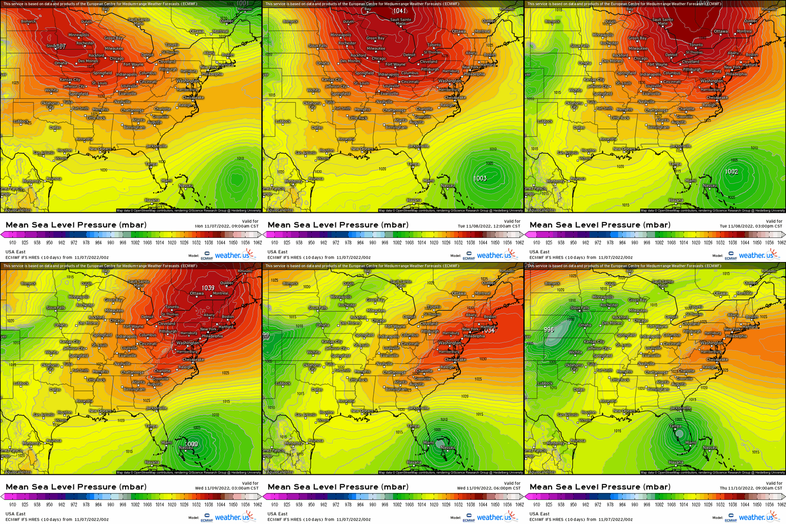
Nicole’s motion is currently NNW, toward a weakness in the subtropical high. That will change soon, however.
As the week wears on, a cold front will approach from the west. This will force the ridge over the Eastern US to slide out to sea. The relocation of the ridge then forces Nicole to take on a more westerly track through the Bahamas and toward the Florida Peninsula.
How quickly the ridge relocates east will determine just where Nicole makes its westerly turn.
Additionally, the speed of the incoming trough will have impacts too. For example: a faster trough will force the ridge out to sea faster, resulting in Nicole taking a quicker turn west. A faster trough would also potentially capture Nicole and sweep it out to sea before land interaction. A slower trough would allow for landfall.
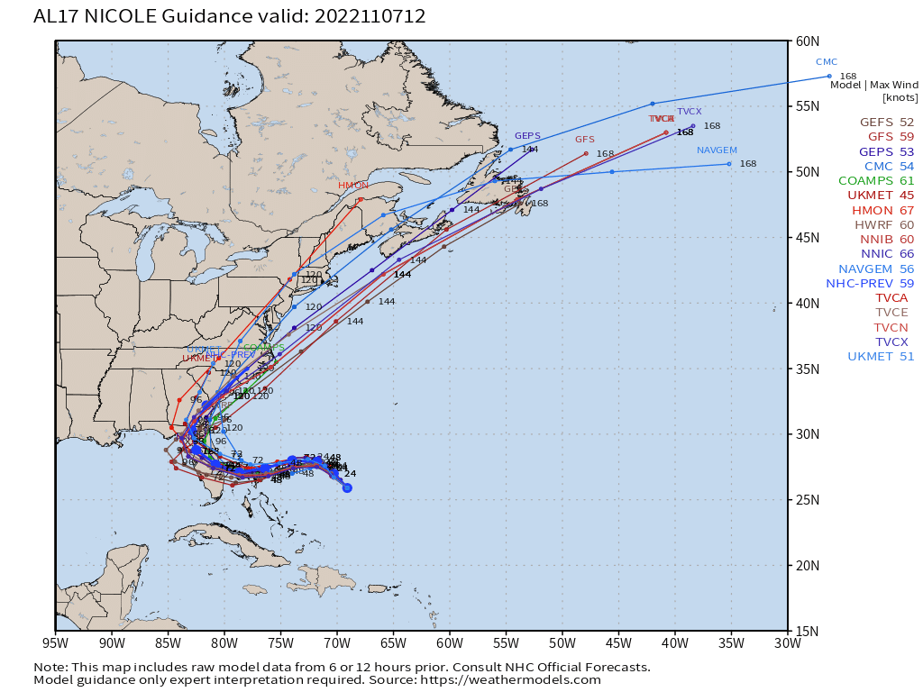
The current forecast is for the trough to be a bit too slow to sweep Nicole out to sea. Landfall on the eastern side of the Florida Peninsula is expected later this week – at least as the forecast stands now. Remember that these things can (and probably will) change some, so monitor the evolution of the forecast daily, especially if you’re in this area.
Now let’s talk about impacts.
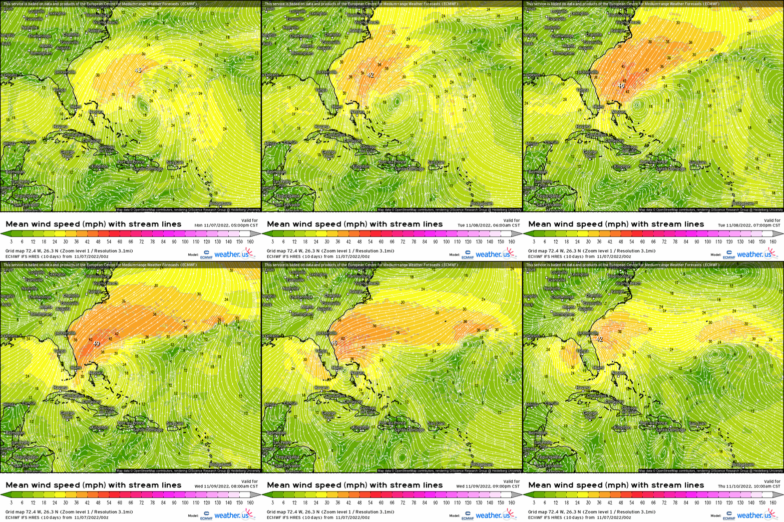
Nicole is currently a subtropical storm. The wind fields on subtropical storms are much larger than we typically see on a purely tropical cyclone. This means that the more intense winds will extend much further from the center.
Before anyone goes and gets worried about significant wind damage: This is not Hurricane Ian. The current forecast is for Nicole to perhaps attain low-end hurricane status. A category 1 hurricane typically has maximum sustained winds of 74-95 mph, with the upper end being attributed to a stronger cat 1. And that’s over open water. Once friction comes into play over land, sustained winds usually end up being substantially less. Higher gusts are, of course, possible as they mix down from aloft, but even if Nicole does manage to attain weak hurricane status, we don’t need to worry about hours and hours of intense winds.
The prolonged exposure to the large wind field Nicole is forecast to have does bring a problem, however.
Take a look at that loop above again. Notice how onshore flow begins for the eastern Florida Peninsula late Tuesday and does not let up through Thursday. Additionally, it doesn’t stay confined to Florida, but will eventually impact most of the southeastern coast. This is bad news – not in terms of sustained winds, but in terms of water.
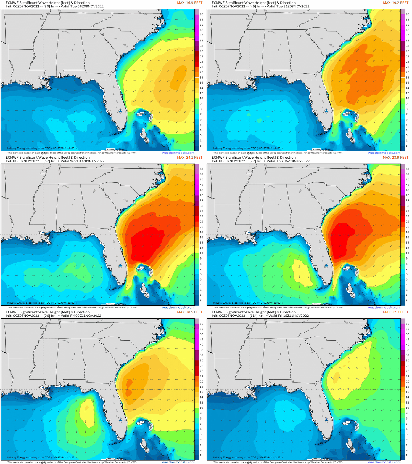
Large waves and an extended period of that onshore push of water will result in coastal flooding. Worse, this onshore push will coincide with predicted King Tides. For those not in the know, King Tides are higher than average high tides that occur seasonally.
If your location is prone to flooding during King Tides, prepare now as the influx of water from STS Nicole’s prolonged onshore flow will likely add to maximum water heights.
If water woes in the form of coastal flooding wasn’t enough, heavy rain leading to freshwater flooding is also a concern.

Some waterways, like the St. John’s River northeast of Orlando, are still in flood from Hurricane Ian. More rainfall will no doubt add to that, and additionally may push other rivers/creeks currently near flood stage back into flood.
As with many tropical cyclones, Nicole’s water component will be the most dangerous part. As I mentioned before, if your location is vulnerable either to coastal flooding or freshwater flooding, prepare now.
What you need to know:
- Nicole is currently forecast to turn west as early as Tuesday and move toward the Bahamas/Eastern Florida.
- Nicole is forecast to potentially strengthen into a hurricane late on Wednesday.
- Water, not wind, will be the main concern. Nicole’s large wind field will allow for prolonged onshore flow on top of King Tides, leading to coastal flooding. Effects will be felt far from the center due to its size.
- Additionally, heavy rain is expected. Rivers/creeks near or at flood stage already will likely flood once again in addition to urban flooding/other freshwater flooding due to heavy rain.
- Monitor the forecast as impacts can change over the next couple of days.
- Focus on IMPACTS not exact track of the center. Due to the size of this storm, impacts will be felt far from the center.
We’ll keep you updated here and on Twitter as the forecast evolves.


