Snow, Heavy Rain, Damaging Wind as Midlevel Low Cranks Over Eastern US
An impressive, slow-moving southern stream midlevel low has already brought significant sensible weather impacts to the US this week, from SoCal fire weather to Gulf Coast severe thunderstorms. As this system phases with a powerful northern stream trough today, significant cyclogenesis along the spine of the Appalachians will lead to yet another chapter of significant atmospheric impacts, this time in the form of heavy precipitation (snow and rain) and potentially damaging wind gusts in the northeastern quarter of the United States.
A surface low will consolidate over the Gulf states through this afternoon as divergence intensifies over the southeast ahead of our developing midlevel bowling ball. 
As usual, the warm and cold sectors of this low will see dramatically different sensible weather. And, with a system this intense, both could end up with reasonably significant impacts.
We’ve already discussed one of tomorrow’s warm sector threats: severe thunderstorms over the Carolinas, which is still looking like a messy mode mix with both damaging wind and tornadoes possible, likely isolated.
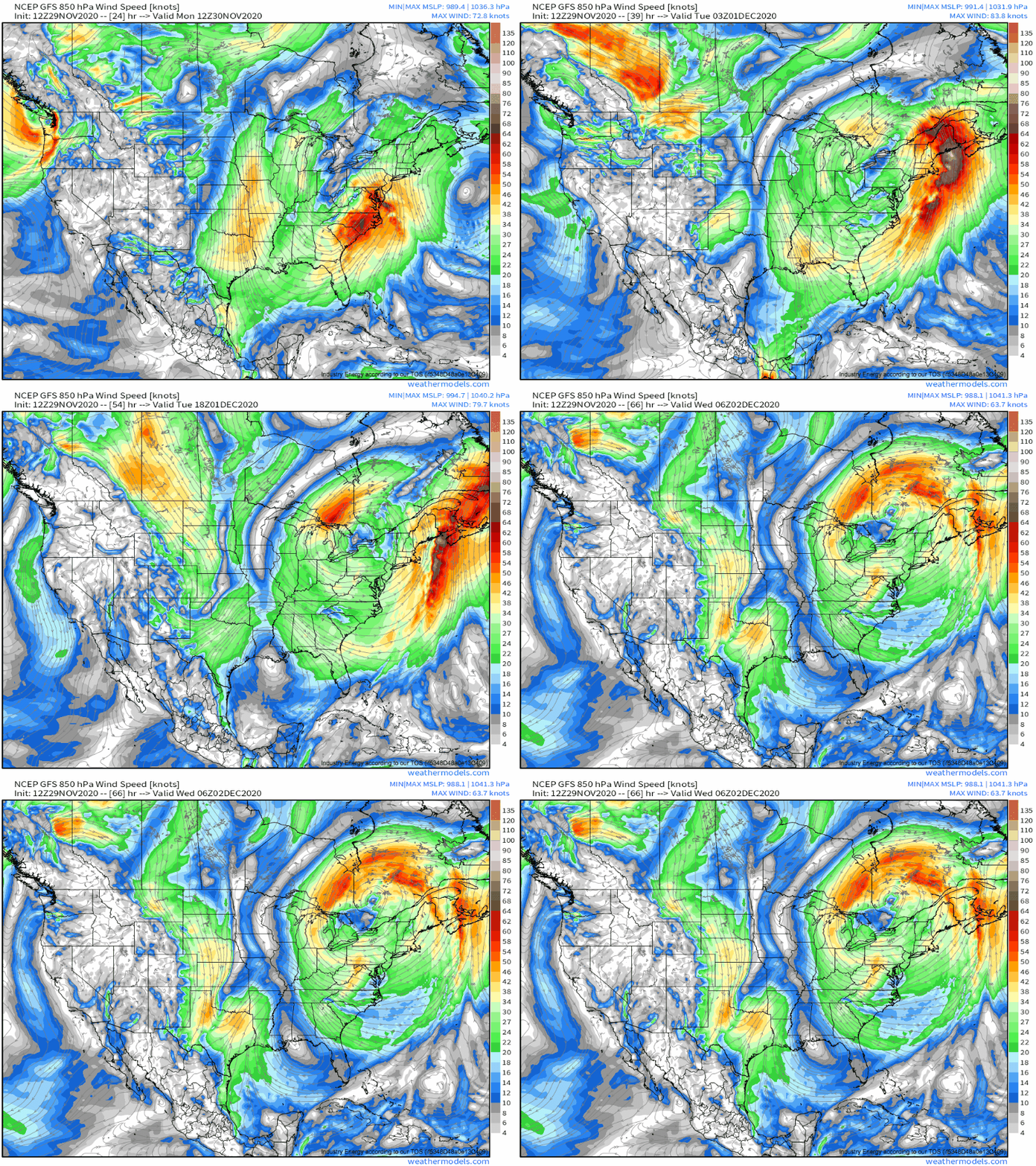
If you remember from my severe weather threat, the big atmospheric driver of sensible weather to the low’s east will be a roaring low-level jet. In terms of convection, it’ll aid in moisture advection and provide a reservoir of high-helicity potential to any developing updrafts. But it’ll also engineer a heavy rain and damaging wind threat further north, over New England.
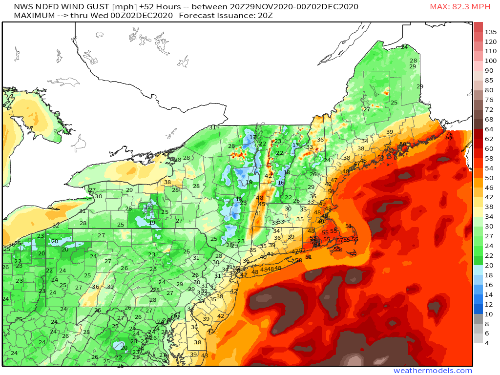
Damaging winds are pretty straightforward: as the low-level cyclone intensifies, so too will a pressure gradient against ridging to the storm’s east. Along this pressure gradient, southerly flow will rush towards the low’s center. 
The most significant jet streak of low level flow with this event will likely skirt the coastal mid-Atlantic before slamming into southeastern New England tomorrow evening. As winds in this jet core exceed 80 knots, it becomes clear that damaging gusts may be possible where mixing is sufficient, and so potential sources must be investigated.
I took this sounding from southeast MA, as the low level jet is most intense over the region. 
Now, the layer from 925mb to 850mb is largely saturated, which means widespread downward mixing of very high wind isn’t that likely. Also, there’s no instability present in the profile, which makes me doubt whether thunderstorms can make it far enough north to mix down significant winds convectively.
However, I also notice a relatively dry layer in the bottom 50-70mb of the atmosphere, evident with the “inverted V” sounding. This means downward transfer of winds may occur, depending on how strong 925mb flow can get. Now, it won’t be quite as strong as the 80 knot 850mb jet, but 925 flow could reach 70-80mph over western New England tomorrow evening and night.
Of course, mixing won’t be fully efficient, but a swath of strong to potentially damaging wind gusts, locally reaching 60mph, will be possible in SE New England. 
The damaging wind threat will continue up the NH/ME coast through Tuesday, likely lingering until early Wednesday over parts of Maine as the midlevel low rotates a slowly weakening LLJ into the coast.
This 850mb jet I’ve been discussing will have more tricks up her sleeve in the low’s warm sector, too. With strong, moderately persistent southerly flow, hitting favorable coastal geometry after thousands of miles over the ocean, an atmospheric river event will be possible!
Now, this won’t be anything to write home about, as the LLJ looks to really stall out too far east for anywhere in the US, except for potentially far SE Maine, to see the type of persistent integrated vapor transport that could cause 5+” of rain to accumulate. But a decent socking of rain is still likely from CT through ME, as the slow-moving cold front (due to large northerly component to motion) interacts with this persistent moisture advection. A broad 1.5-2.5″ of rain is a good bet within a few counties of the coast. Where lift can be more persistent, like along favorably oriented topography of NH and ME, 2-4″ is possible. And over SE Maine, where the western edge of a true atmospheric river seems likely to set up, 4-6″ of rain may fall!
But, of course, the warm sector is only half of the equation with a storm like this!
Tomorrow afternoon, as convection begins intensifying and potentially rotating over the Carolinas, with a few hours still to go before New England is punched by heavy rain and damaging wind gusts, stratiform precipitation within a comma-head convergence zone to the surface low’s northeast will be whacked by cold air advection from the northwest, and snow will start falling across the Ohio valley.
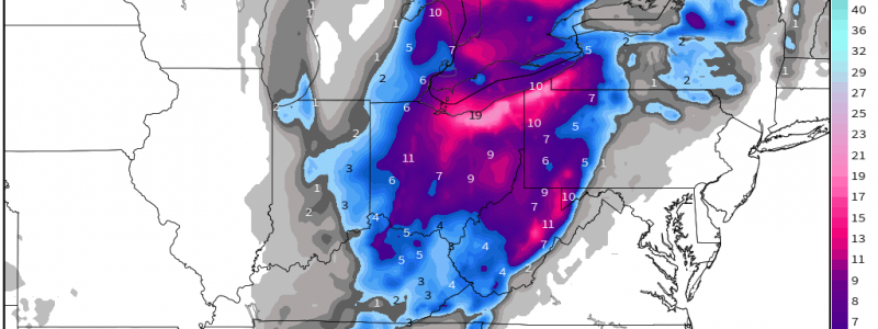
The first wave of snow will come as the deepening low climbs the Appalachians tomorrow. This will be a pretty typical quick band of wrap-around precipitation, with any initial rain quickly turning into heavy, wet snow as cold air rushes towards the deepening low. By tomorrow night, temperatures will have dropped quickly to the mid 20s over much of the Ohio valley, with stiff winds making it feel even colder. As this happens, snow ratios will increase, and snow will be noticeably drier and lighter. This will increase the efficiency of snowfall, and more than 6″ of snow will probably have accumulated in parts of Central Ohio most impacted by banding by midnight.
As Monday turns into Tuesday, the driver of the snow will increasingly be the vertically stacked primary low moving very slowly over S. Ontario. A nearly N-S band will continue to drop moderate to heavy snow Tuesday over E Ohio and W Pennsylvania into Tuesday night, with heavy snow wherever lake-related moisture can move ashore, which should primarily be just south of Erie.
By Wednesday morning, snow will have moved into NY as the low begins to weaken and pull away. By then, a large swath of OH and W. PA will have seen plowable snow, with local maxima probably exceeding 15″ just south of the Lakes, over NE Ohio.
This snowfall map from the Euro, taking the Kuchera ratio into account, seems pretty reasonable to me, although it may be too heavy with snowfall over central Ohio. 
As a strong cyclone intensifies up the spine of the Appalachians tomorrow, a multitude of hazards will impact the northeastern quarter of the US. In the warm sector, the New England will see heavy rain and strong winds, while in the cold sector, heavy snow is possible in the Ohio Valley. We will keep you posted here and on twitter!


